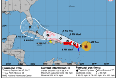
National Hurricane Center The latest forecast for Hurricane Irma.
The newest potential track for Hurricane Irma shows it hitting Florida first before making a beeline toward South Carolina.
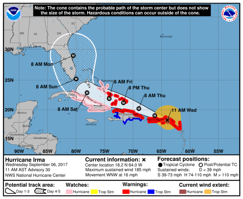
Irma, which was a Category 5 hurricane, is set to make landfall this weekend and bring with it damaging winds and heavy amounts of rain. The latest track, which was released at 11 a.m. September 6 by the National Weather Service, shows the outer banks of South Carolina in Irma’s path.
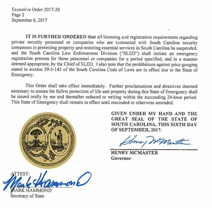
Although the timing and exact track aren’t yet definitive, South Carolina Governor Henry McMaster declared a state of emergency Wednesday. The declaration allows for state officials to prepare for Irma by setting up an operations center and coordinating efforts to ensure safety of its residents.
NEW: South Carolina Gov. Henry McMaster asks citizens to prepare for Hurricane Irma; declares state of emergency t.co/SyUjxRLnty

Evacuation orders haven’t yet been declared for any of the counties in the state, but they are believed to be ordered in the coming days. Officials are urging residents to become familiarized with evacuation routes, and the Emergency Management Division has increased its readiness to OPCON 4, the next highest level above normal activities, The Post and Courier reported.
It’s vital to have an emergency plan when a hurricane is near, and officials say that starts with knowing your evacuation zone. Click here for a map of the evacuation zones for the Central Coast area.
Here’s a map showing the evacuation routes for the coastal area, including Charleston County.
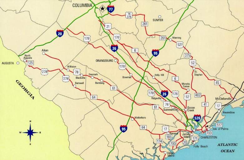
A map showing the evacuation maps for the central conglomerate of South Carolina.
Hey Charleston! Be prepared! Know your Evacuation Routes!! Stay off of Interstate 26 unless you must use it.
#HurricaineIrma #chsnews

The South Carolina Department of Transportation also has a mobile application to make travel in case of an evacuation easier. Click here to view the app.
In the case of an evacuation, emergency shelters will also be provided. However, Charleston County advises to only use a shelter as a “place of last resort.”
“In the event that you must use a shelter, there is one type: American Red Cross,” the county says.
To find an emergency shelter near you, click here to access the Red Cross’ shelter locator.
Also in the event of an evacuation, Charleston County provides those without proper transportation the opportunity to take a bus to evacuate.
Read the list below for the places a buses would pick up and transport residents looking to evacuate.
North Charleston #1 (Lower North Charleston)
Economy Inn & Suites – 5020 Rivers Avenue
Bus Stop at Rivers Ave. and Gullah – 3902 Rivers Avenue
Military Magnet Academy – 2950 Carner Avenue
Felix Pinckney Community Center – 4790 Hassell Avenue
Gussie Greene Community Center – 2012 Success Street
Bus stop at 2336 Meeting & Delaware Streets (Union Heights)
Fabian Shopping Center 4310 Rivers Avenue (Old Piggly Wiggly)
Felix C. Davis Community Center (Park Circle) – 4800 Park Circle
Ron McNair School – 3795 Spruill Avenue
Bus Stop @ Spruill & Baxter – Near Chinese Deli
Perry-Webb Community Center – 3200 Appleton Avenue
Evening of Prayer Church 2361 Spruill Ave. Spruill & Echo Ave(Union Heights)
Bus stop at Meeting & Hackeman Avenue (Union Heights)
North Charleston #2 (Upper North Charleston)
Ladson Elementary School – 3321 Ladson Road (Ladson)
Food Lion at Remount Road & N. Rhett -1213 Remount Rd
Bus Stop @ 1473 Remount Rd – Revelation Church of Christ
Bus Stop @ Rivers & Trident Technical College – 7000 Rivers Ave
Charleston Korean United Methodist Church – 2745 Shadow Drive (Deer Park)
Kmart Super Center – 8571 Rivers Avenue (Otranto)
Wal Mart – 7400 Rivers Avenue Unit A
North Charleston Center (Northern Tool) – 5900 Rivers Avenue
Pepperhill Elementary School – 3300 Creola Lane
BP at 2707 Ashley Phosphate Road & Stall Road
Rivers Park Business Center – 8085 Rivers Avenue
North Charleston #3 (Dorchester Road Corridor)
Jeanene Batten Community Center – 3690 Dorchester Rd
Goodwin Elementary School – 5501 Dorchester Road
Lambs Elementary School – 6800 Dorchester Road
Food Lion – 7550 Dorchester Road
Oak Ridge Plaza (old Piggly Wiggly) – 5060 Dorchester Road
Brentwood Plaza – 4400 Dorchester Road
Bus Stop @ 4707 Dorchester Rd – Low Country Harley Davidson
Bus Stop @6550 Dorchester Rd – St Thomas the Apostle Catholic
Mount Pleasant #1 (Arthur Ravenel Bridge to the Isle of Palms Connector)
The Plaza East Cooper Plaza – 615 Johnnie Dodds Blvd
Bi Lo – 1440 Ben Sawyer Boulevard
Public Library – 1133 Mathis Ferry Road
Moultrie Middle School (rear side) – 645 Coleman Boulevard
Look for this sign
designating a pickup
point location
near you.
24
Town Center (Belk) – 1200 Belk Drive
Northcutt Plaza – 280 W. Coleman Blvd
Mount Pleasant #2 (North of the Isle of Palms Connector)
Guy C. Lee – 2985 Highway 17 North
OLD Laing Middle School – 2213 Highway 17 North
Jennie Moore Elementary School – 2735 Bullrush Basket Lane
Belle Hall Elementary School – 385 Egypt Road
“FUTURE” Lucy Garrett Beckman High School – 1560 Mathis Ferry Road
Harris Teeter – 2031 Hwy 41
Whitesides Elementary School – 1565 Rifle Range Road
Isle of Palms and Sullivan’s Island
Isle of Palms Recreation Center – 24 28th Avenue (Isle of Palms)
IOP US Post Office – 1000 Palm Blvd
Sullivan’s Island Elementary School – 2014 Mike Perkis Place (Sullivan’s Island)
Sunrise Presbyterain Church – 3222 Middle Street (Sullivan’s Island)
Awendaw and McClellanville
South Santee Community Center – 710 S. Santee Road off Rutledge Road (South Santee)
McClellanville Middle School – 711 Pinckney Street (McClellanville)
St. James Santee Elementary School – 8900 Highway 17 North (McClellanville)
Berkeley Co-Op – 7200 Highway 17 and Union Rd (Awendaw)
Sawgrass Center – 6448 Highway 17 (Awendaw)
Seewee Outpost – 4853 Highway 17 North (Awendaw)
OLD Berkeley Co-Op – 3745 Highway 17 North and Lieben Road – (Mt. Pleasant)
Dollar General – 10141 Hwy 17N
McClellenville Dinner – 9905 Hwy 17N
Mt. Nebo AME Church – 5600 Hwy 17N
Greater Zion AME Church – 4174 Hwy 17N
Downtown Charleston
Charleston Progressive School – 382 Meeting Street
Archer Building-OLD Sanders Clyde Elementary School – 220 Nassau Street
Burke High School – 244 President Street
Joseph Floyd Manor – 2106 Mt. Pleasant Street
Gaillard Municipal Auditorium – 95 Calhoun Street
Memminger Elementary School – 20 Beaufain Street
Bridgeview Village Apt Complex – 108 D North Romney
Freddie Whaley Recreation Center – 1810 Doscher Avenue
West Ashley
Bi-Lo – 3125 Bees Ferry Road
West Ashley Middle School (Old Middleton High School) – 1776 William Kennerty Drive
Springfield Elementary School – 2741 Clover Street
St. Andrews Middle School (Old St. Andrews High School) – 721 Wappoo Road
Doscher’s IGA – 1133 Savannah Highway (Highway 17)
Citadel Mall – 2070 Sam Rittenberg Boulevard
Publix Grocery Store – 1401 Sam Rittenberg Boulevard, Charleston
25
Charleston First Assembly – 2957 Savannah Highway (Highway 17)
West Ashley Vet – 840 St. Andrews Blvd
West Wood Plaza – 1812 Sam Rittenberg Hwy
Home Depot – 2008 Magwood Drive
Publix – 3642 Savannah Hwy
James Island
Earth Fare – 74 Folly Road (South Windermere Shopping Center)
Fast Point Food Store – 1029 Harbor View Road (Harbor View Road at Quail Drive)
Wal-Mart – 1231 Folly Road and Griffith Road
Folly Beach Shopping Center – 907 Folly Road (Camp Road and Folly Road)
Harris Teeter – 1739 Maybank Highway and Folly Road
Hot Wheels – 1523 Folly Road
Camp Center – 1238 Camp Road
Harris Teeter – 1985 Folly Road and Sol Legare Road
Harris Teeter – 675 Folly Road
Murray Elementary School – 691 Riverland Drive
James Island High School – 1000 Ft. Johnson Road
Hideaway Pizza Kitchen – 608-AHarborview Road & Clearview, near Ft. Johnson
Folly Beach
Folly Boat Landing – Folly Road at ICW 97 Center Street
Johns Island
Charleston Executive Airport – 2700 Fort Trenholm Road (off River Road)
Mount Zion Elementary School – 3464 River Road
Charleston Collegiate (Sea Island Academy) – 2024 Academy Drive
Island Center Executive Offices – 3690 Bohicket Road # 3A
Bi-Lo – 3575 Maybank Highway (Main Road and Maybank Highway)
St. John’s High School – 1518 Main Road
Food Lion – 2770 Maybank Hwy
Stono Market and Tomato Shed – 842 Main Road
Hebron Zion Presbyterain Church – 2915 Bohicket Road
Wadmalaw Island
Frierson Elementary School – 6133 Maybank Highway
New Jerusalem A.M.E. Church – 6179 Bears Bluff Road
Salem Presbyterian Church – 5591 Maybank Hwy
Kiawah Island and Seabrook Island
Newton Farm – 149 Village Green Lane (Kiawah Island)
Sheriff’s Office Substation – 4305 Betsy Kerrison Parkway
Adam’s Run
Adam’s Run Civic Center – 5166 Highway 174
St. Paul’s Fire Station – 5674 Hwy 174
Shilo Baptist Church – 5629 Parkers Ferry Road
Edisto Island
E-Z Stop – 2410 Highway 174
Jane Edwards Elementary School – 1960 Jane Edwards Road
26
True Value Hardware Store – 487 Hwy 174
Geechi Boy Grit Market and Mill – 2975 Hwy 174
Trinity Episcopal Church – 1589 Hwy 174
Enterprise Bank – 804 Oyster Park Drive
Hollywood, Ravenel and Yonges Island
Rantowles Baptist Church – 4590 Highway 162 (Hollywood)
Baptist Hill High School – 5117 Baptist Hill Road (Hollywood)
Allen AME Church (Meggett) – 6940 Ethel Post Office Road (Hollywood)
Minnie Hughes Elementary School – 8548 Willtown Road (Hollywood)
Mt. Horr A.M.E. Church – 4360 Highway 174 (Hollywood)
Ravenel Town Hall – 5962 Highway 165, Suite 100 (Ravenel)
CC Blaney Elementary School – 7184 Highway 162 (Yonges Island)
St. Paul’s Presbyterian Church – 7404 Hwy 162
St. Paul’s Episcpal Church – 4981 Chapel Hill Road
Calvery Baptist Church – 4744 Hwy 165
EB Ellington Elementary School – 5540 Old Jacksonboro Road