NHC Cudjoe Key was the site of the first landfall.
Hurricane Irma made its first landfall in the U.S. in Cudjoe Key around 9:10 a.m.
That news was announced by the National Hurricane Center, which wrote, “Hurricane #Irma makes landfall at Cudjoe Key in the lower Florida Keys.”
The NHC also wrote:
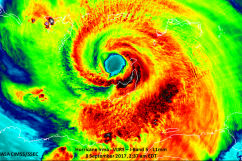
“The center of Hurricane Irma made landfall at Cudjoe Key in the lower Florida Keys at 9:10 am EDT. A gust to 106 mph (171 km/h) was just reported at the National Key Deer Refuge in Big Pine Key.
SUMMARY OF 910 AM EDT…1310 UTC…INFORMATION
———————————————-
LOCATION…24.7N 81.5W
ABOUT 20 MI…30 KM ENE OF KEY WEST FLORIDA
MAXIMUM SUSTAINED WINDS…130 MPH…215 KM/H
PRESENT MOVEMENT…NNW OR 330 DEGREES AT 8 MPH…13 KM/H
MINIMUM CENTRAL PRESSURE…929 MB…27.43 INCHES”
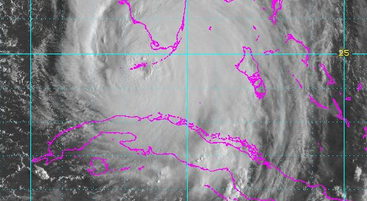
Three keys – Cudjoe, Big Pine Key and Summerland Key – were in the eye of the hurricane on Sunday morning. Irma had strengthened overnight into a Category 4 storm again.
Big Pine Key, Summerland Key and Cudjoe Key in the eye of Hurricane #Irma. Do not venture outside t.co/tW4KeGdBFb @NWS @NOAA
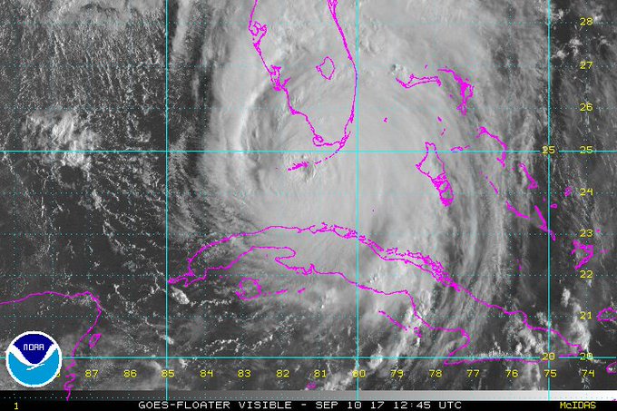
The hurricane is also expected to make a second landfall in southwestern Florida, probably somewhere between Naples and Sarasota. The hurricane, at 8 a.m., was 110 miles from Naples. See ways to track Hurricane Irma’s location in real time here.
Cudjoe Key has a population of only about 1,700 people. It’s an unincorporated community in Monroe County, Florida.
According to Mapquest, “Cudjoe Key is a census-designated place in Monroe County, Florida, on an island of the same name in the lower Florida Keys. As of the 2000 census, the CDP had a total population of 1,695. The United States Army activated Cudjoe Key Air Force Station in 1959 to track missiles traveling through the Eglin Gulf Test Range.”
Cudjoe Key was originally called Littleton Island, according to Mapquest. TripAdvisor lists only one hotel in Cudjoe Key. See vacation photos from the key here.
There is a Facebook page that rounds up what there is to do in Cudjoe Key. You can see it here.
Track the hurricane in real time with these sites: