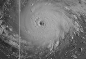
National Weather Service Hurricane Irma on September 5.
Hurricane Irma became a dangerous Category 5 storm with wind speeds of 175 miles per hour. The hurricane was headed toward Florida, but what are the chances it could hit Gainesville?
The September 7 weather forecast for Gainesville lists the possibility of tropical storm conditions for Sunday, Sunday night and Monday, but no longer listed hurricane conditions. The storm is very unpredictable, though, and precautions should be taken.
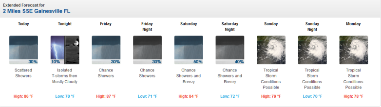
NWSGainesville, Florida weather forecast as of the morning of September 7.
Track the storm here. Read the latest news on evacuation possibilities for Gainesville here.
Here’s the September 7 forecast cone:
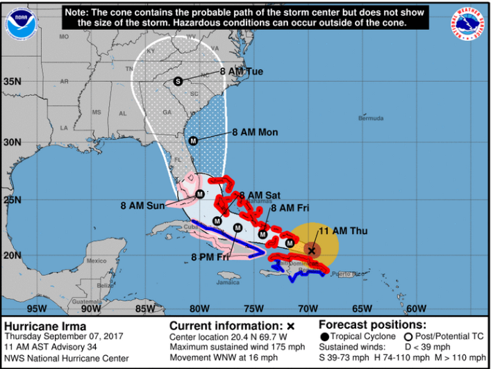
NWSThe Hurricane Irma forecast for 11 a.m. on Thursday, September 7.
Here’s another look:
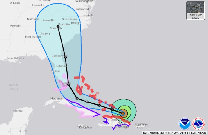
NOAAThe latest Hurricane Irma map track as of September 7.
The storm remains unpredictable.
“Hurricane Center and National Weather Service forecasters warned it’s too soon to tell what Irma’s impacts could be in Florida or other hurricane-prone areas of the United States,” Gainesville.com reported. “Forecasters must wait to see if Irma takes a predicted turn to the north as it travels around a high-pressure ridge over the Atlantic Ocean and see how the ridge and hurricane interact with a trough moving across the U.S.”
Spaghetti models showed the storm tracking to the east. The question is whether it goes out to sea or not.
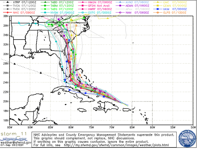
South Florida Waste Management DistrictThursday morning spaghetti model.
See updated radar maps for Gainesville here. Note that the community relies on the Jacksonville weather office. See the hourly forecast here. See infrared satellite maps here. See an updated weather page for Gainesville here.
This is the hazardous weather outlook for the area including Gainesville on September 7 from the National Weather Service:
“DAYS TWO THROUGH SEVEN…Friday through Wednesday…There is increasing chances for Tropical Storm strength winds to
develop over northeast Florida and southeast Georgia Sunday through Monday. Onshore flow will increase through the weekend as Hurricane Irma approaches south Florida. Rough and high surf, beach erosion, coastal flooding and deteriorating marine conditions over the adjacent Atlantic waters are expected. Locally heavy rainfall will be possible especially along the Atlantic coast this weekend. An elevated rip current risk will continue through the weekend as swells and winds from Hurricane Irma increase in the local Atlantic waters.
See the Irma briefing for the Gainesville area here. Note, again, that the NWS forecasts come out of the Jacksonville office for Gainesville.
Here’s the extended weather forecast for Gainesville:
“This Afternoon (September 7)
Scattered showers and thunderstorms, mainly between 2pm and 4pm. Mostly cloudy, with a high near 86. Light northeast wind. Chance of precipitation is 30%.
Tonight
Isolated showers and thunderstorms before 7pm. Mostly cloudy, with a low around 70. Calm wind becoming northeast around 6 mph in the evening. Chance of precipitation is 10%.
Friday
A slight chance of showers before 8am, then a chance of showers after 2pm. Mostly cloudy, with a high near 87. Northeast wind 7 to 13 mph. Chance of precipitation is 30%.
Friday Night
A chance of showers before 8pm, then a slight chance of showers after 2am. Mostly cloudy, with a low around 71. Northeast wind around 10 mph. Chance of precipitation is 30%.
Saturday
A 50 percent chance of showers and thunderstorms, mainly after 8am. Mostly cloudy, with a high near 84. Breezy, with a northeast wind 11 to 17 mph.
Saturday Night
A 40 percent chance of showers and thunderstorms. Cloudy, with a low around 72. Breezy.
Sunday
Tropical storm conditions possible. Showers likely and possibly a thunderstorm. Cloudy, with a high near 79. Chance of precipitation is 70%.
Sunday Night
Tropical storm conditions possible. Showers likely and possibly a thunderstorm. Cloudy, with a low around 70. Chance of precipitation is 60%.
Monday
Tropical storm conditions possible. A 50 percent chance of showers and thunderstorms. Mostly cloudy, with a high near 78.
Monday Night
Tropical storm conditions possible. A 20 percent chance of showers and thunderstorms. Mostly cloudy, with a low around 67.
Tuesday
A 20 percent chance of showers and thunderstorms. Mostly sunny, with a high near 86.
Tuesday Night
Partly cloudy, with a low around 69.
Wednesday
A 20 percent chance of showers and thunderstorms. Mostly sunny, with a high near 87.”