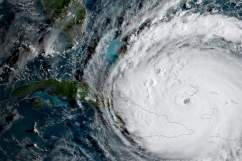
Florida could start feeling the effects of Hurricane Irma by sometime on Saturday, although winds and rains and storm surges may start arriving even earlier than that. The monster hurricane is currently expected to be a powerful Category 4 when it makes landfall. You’ll want to keep a close eye on Irma’s progress, and this live stream feed will help. Above is a live radar feed showing two different streams, a map from the National Hurricane Center, and web cams from areas in the Hurricane’s path. (To see more local web cam live streams as the hurricane arrives in Florida, see Heavy’s story here.)
For the most updated live radar story, see Heavy’s updated live radar feeds here.
Below are more local and national news feeds, reporting live on Irma’s location and projected path. Some of these feeds may periodically go down. We will keep this post updated with new streams as needed.
Next up, a live feed from the Washington Post:
Thousands of residents in Miami and the Florida Keys have been evacuating so they can reach safer areas inland. This could be one of the largest evacuations in U.S. history, CNN reported. Motorists were waiting hours in some places for fuel, and the Florida Highway Patrol escorted fuel tankers so they could resupply local gas stations. Some people reported that trips which should have taken 6 to 7 hours ended up taking 12 hours, driving about 20 mph.
Here is a feed from different news sources discussing Irma:
And next is a stream from FOX:
And here are more live cams and radars of Hurricane Irma:
This feed has numerous feeds and radars embedded:
And a live stream from Fox 10 Phoenix:
Are you looking for local web cam feeds in Florida? See Heavy’s story below.