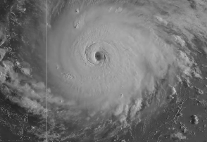
National Weather Service Hurricane Irma on September 5.
Hurricane Irma is a dangerous Category 5 storm with wind speeds of 175 miles per hour. The hurricane was headed toward Florida, where the governor has declared a state of emergency, but what are the chances it could hit Melbourne?
The September 7 forecast for Melbourne now says that hurricane conditions are possible for Sunday and Sunday night.
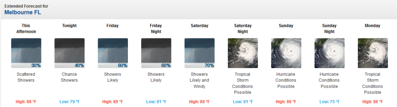
NWSMelbourne, Florida Thursday September 7 forecast.
Irma was headed toward southern Florida, and the latest models on September 7 showed it had shifted to the east, but be aware that the storm is unpredictable.
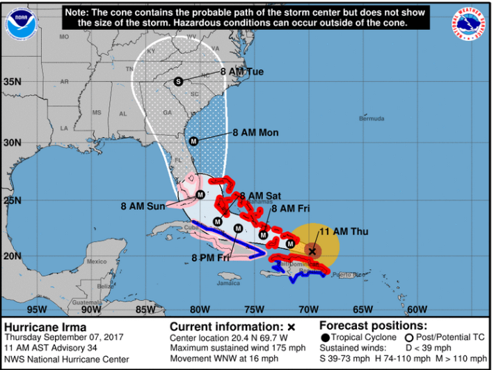
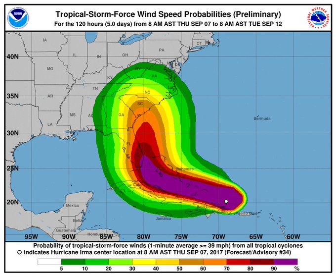
NWSThe Hurricane Irma forecast for 11 a.m. on Thursday, September 7.
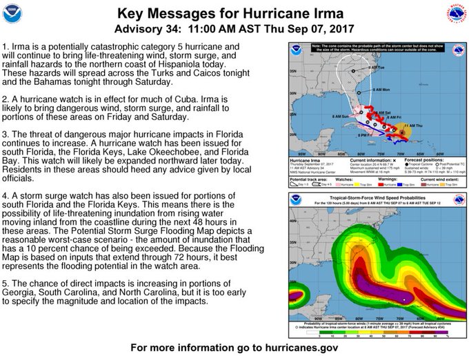
Here are the key messages from the National Hurricane Center for September 7:
Key Messages on Hurricane #Irma as of 11 am AST/EDT:
Track the path of Hurricane Irma here. See updated radar for Melbourne here. Get infrared satellite maps here. See an hourly forecast here.
Don’t focus on the exact track of #Irma. There is a high probability of trop storm and hurricane conditions well away from the center.
The hazardous weather outlook for east central Florida, including Melbourne, as of September 7 reads:
“DAYS TWO THROUGH SEVEN…FRIDAY THROUGH WEDNESDAY. Shower and thunderstorm chances will remain above normal through
late week as the weak cool front stalls and becomes diffuse over east central Florida. While forecast for this weekend still remains somewhat uncertain, the threat for impacts from Major Hurricane Irma continues to increase, with the possibility that these impacts could be significant.
Major Hurricane Irma is forecast to move west-northwest into the eastern Florida Straits on Saturday, then turn north and make its closest approach to central Florida, through Sunday night or early Monday. While it is still too early to be specific about direct impacts that Irma will have on east central Florida, deteriorating weather conditions, with increasing winds and widespread rain and squalls, are likely, and boating and surf conditions are expected to
become quite dangerous by this weekend.
Continue to monitor the latest forecasts for Irma from the National Hurricane Center and your local National Weather Service. You should also be continuing your hurricane preparations. Your hurricane kit should be fully stocked and you should be making plans to secure your property at this time, as Irma draws nearer to Florida. If you live in a flood prone area, and/or your home is susceptible to winds, you should make contingency plans for sheltering from the storm, and know your evacuation routes to safety.”
The storm remains unpredictable.
“Hurricane Center and National Weather Service forecasters warned it’s too soon to tell what Irma’s impacts could be in Florida or other hurricane-prone areas of the United States,” Gainesville.com reported. “Forecasters must wait to see if Irma takes a predicted turn to the north as it travels around a high-pressure ridge over the Atlantic Ocean and see how the ridge and hurricane interact with a trough moving across the U.S.”
See the weather forecast page for Melbourne here.
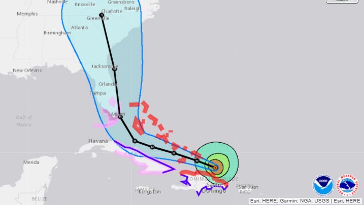
NOAAThe latest Hurricane Irma map track as of September 7.
The extended forecast for Melbourne is as follows:
“This Afternoon
Scattered showers and thunderstorms. Partly sunny, with a high near 88. Northeast wind around 10 mph. Chance of precipitation is 30%.
Tonight
A chance of showers and thunderstorms before 2am, then a slight chance of showers. Mostly cloudy, with a low around 79. Northeast wind around 10 mph. Chance of precipitation is 40%.
Friday
A slight chance of showers, then showers likely and possibly a thunderstorm after 8am. Mostly cloudy, with a high near 89. East northeast wind 10 to 15 mph, with gusts as high as 20 mph. Chance of precipitation is 60%. New rainfall amounts between a quarter and half of an inch possible.
Friday Night
Showers likely and possibly a thunderstorm. Mostly cloudy, with a low around 81. East northeast wind around 15 mph, with gusts as high as 20 mph. Chance of precipitation is 60%.
Saturday
Showers likely and possibly a thunderstorm. Cloudy, with a high near 88. Windy, with an east northeast wind 15 to 20 mph, with gusts as high as 30 mph. Chance of precipitation is 70%.
Saturday Night
Tropical storm conditions possible. Showers likely and possibly a thunderstorm. Cloudy, with a low around 81. Chance of precipitation is 70%.
Sunday
Hurricane conditions possible. Showers and possibly a thunderstorm. High near 86. Chance of precipitation is 80%.
Sunday Night
Hurricane conditions possible. Showers and possibly a thunderstorm. Low around 75. Chance of precipitation is 80%.
Monday
Tropical storm conditions possible. A 50 percent chance of showers and thunderstorms. Mostly cloudy, with a high near 86.
Monday Night
A 20 percent chance of showers and thunderstorms. Partly cloudy, with a low around 72. West southwest wind 10 to 15 mph, with gusts as high as 25 mph.
Tuesday
A 20 percent chance of showers. Mostly sunny, with a high near 88. West southwest wind 10 to 15 mph, with gusts as high as 20 mph.
Tuesday Night
A 20 percent chance of showers. Partly cloudy, with a low around 75. West southwest wind around 10 mph.
Wednesday
A 20 percent chance of showers and thunderstorms. Mostly sunny, with a high near 88. West wind around 10 mph.”