National Hurricane Center
Hurricane Irma moves closer to Florida, with the outermost bands starting to impact south Florida already. What are the latest updates for Miami and Miami-Date County? Here’s the key information you need to know, as of the evening of Sept. 9:
Tropical storm force winds are expected in Miami tonight.
Tropical Storm force winds are expected in #Miami later tonight. Commissioner @FrancisSuarez urges residents not to let their guard down.
The Miami Herald reported that as Irma moves west, Miami might be spared the worst rather than receiving a direct hit. But this isn’t the time to let down your guard.
As of 4 p.m., more than 10,000 homes and businesses in the city had already lost power.
As of 4:30pm, 10,710 homes & small business in City have lost power. To report outage, call 1-800-4-Outage or go to t.co/7FXCDfNHBJ
A recent advisory from the National Weather Service:
Key Messages for #Irma advisory 43
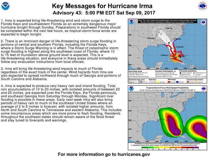
Much of Florida is expected to experience dangerous wind impacts from Irma, along with portions of Georgia, Alabama, and South Carolina.
#Irma is expected to bring dangerous wind impacts to much of Florida, along with portions of Georgia, Alabama and South Carolina.
Here is a full public advisory from the National Weather Service as of 8 p.m. Eastern:
SUMMARY OF WATCHES AND WARNINGS IN EFFECT:
A Storm Surge Warning is in effect for…
* South Santee River southward around the Florida peninsula to the Suwanee River
* Florida Keys
* Tampa BayA Storm Surge Watch is in effect for…
* North of the Suwanee River to Ochlockonee RiverA Hurricane Warning is in effect for…
* Fernandina Beach southward around the Florida peninsula to Indian Pass
* Florida Keys
* Lake Okeechobee
* Florida Bay
* Cuban provinces of Camaguey, Ciego de Avila, Sancti Spiritus, Villa Clara, Matanzas, and Havana
* Andros Island, Bimini, and Grand BahamaA Hurricane Watch is in effect for…
* North of Fernandina Beach to Edisto BeachA Tropical Storm Warning is in effect for…
* West of Indian Pass to the Okaloosa/Walton County Line
* North of Fernandina Beach to South Santee RiverA Storm Surge Warning means there is a danger of life-threatening inundation, from rising water moving inland from the coastline, during the next 36 hours in the indicated locations. For a depiction of areas at risk, please see the National Weather Service Storm Surge Watch/Warning Graphic, available at hurricanes.gov. This is a life-threatening situation. Persons located within these areas should take all necessary actions to protect life and property from rising water and the potential for other dangerous conditions. Promptly follow evacuation and other instructions from local officials.
A Storm Surge Watch means there is a possibility of life-threatening inundation, from rising water moving inland from the coastline, in the indicated locations during the next 48 hours. For a depiction of areas at risk, please see the National Weather Service Storm Surge Watch/Warning Graphic, available at hurricanes.gov.
A Hurricane Warning means that hurricane conditions are expected somewhere within the warning area. Preparations to protect life and property should be rushed to completion.
A Hurricane Watch means that hurricane conditions are possible within the watch area. A watch is typically issued 48 hours before the anticipated first occurrence of tropical-storm-force winds, conditions that make outside preparations difficult or dangerous.
A Tropical Storm Warning means that tropical storm conditions are expected somewhere within the warning area.
Interests elsewhere in Cuba and the southeastern United States should monitor the progress of Irma.
For storm information specific to your area in the United States, including possible inland watches and warnings, please monitor products issued by your local National Weather Service forecast office. For storm information specific to your area outside the United States, please monitor products issued by your national meteorological service.
DISCUSSION AND 48-HOUR OUTLOOK
——————————
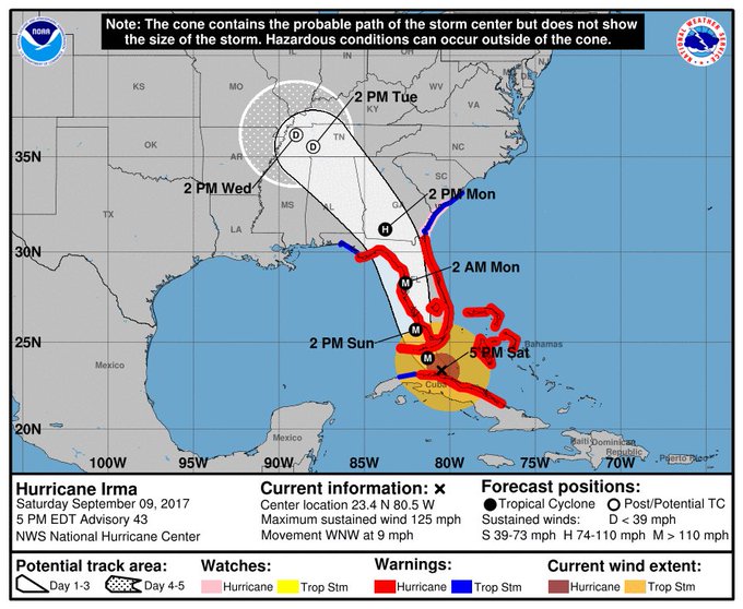
At 800 PM EDT (0000 UTC), the eye of Hurricane Irma was located by a NOAA Hurricane Hunter aircraft and NWS Doppler radar near latitude 23.3 North, longitude 80.8 West. Radar loops indicate that Irma has temporarily slowed down, but the hurricane has been moving toward the west-northwest near 7 mph (11 km/h) since earlier today. A northwest motion is expected to begin tonight with a turn toward the north-northwest on Sunday. On the forecast track, the core of Irma will continue to move near the north coast of Cuba during the next few hours, and should be near the Florida Keys Sunday morning. The hurricane is expected to move along or near the southwest coast of Florida Sunday afternoon.A NOAA Hurricane Hunter aircraft has found that Irma’s intensity is a little lower, and the maximum sustained winds are estimated to be near 120 mph (195 km/h) with higher gusts. Irma is a category 3
hurricane on the Saffir-Simpson Hurricane Wind Scale. Irma is forecast to restrengthen once it moves away from Cuba and remain a powerful hurricane as it approaches Florida.Hurricane-force winds extend outward up to 70 miles (110 km) from the center, and tropical-storm-force winds extend outward up to 195 miles (315 km). Marathon International Airport recently reported a sustained wind of 48 mph (77 km/h) and a gust to 67 mph (108 km/h).
The minimum central pressure based on aircraft data is 932 mb (27.52 inches).
HAZARDS AFFECTING LAND
———————-
STORM SURGE: The combination of a dangerous storm surge and the tide will cause normally dry areas near the coast to be flooded by rising waters moving inland from the shoreline. The water is expected to reach the following HEIGHTS ABOVE GROUND if the peak surge occurs at the time of high tide…Cape Sable to Captiva…10 to 15 ft
Captiva to Ana Maria Island…6 to 10 ft
Card Sound Bridge through Cape Sable, including the Florida Keys…
5 to 10 ft
Ana Maria Island to Clearwater Beach, including Tampa Bay…
5 to 8 ft
North Miami Beach to Card Sound Bridge, including Biscayne Bay… 4 to 6 ft
South Santee River to Fernandina Beach…4 to 6 ft
Clearwater Beach to Ochlockonee River…4 to 6 ft
Fernandina Beach to North Miami Beach…2 to 4 ftThe deepest water will occur along the immediate coast in areas of onshore winds, where the surge will be accompanied by large and destructive waves. Surge-related flooding depends on the relative timing of the surge and the tidal cycle, and can vary greatly over short distances. For information specific to your area, please see products issued by your local National Weather Service forecast office.
The combination of a life-threatening storm surge and large breaking waves will raise water levels ABOVE NORMAL TIDE LEVELS by the following amounts within the hurricane warning area near and to the north of the center of Irma. Near the coast, the surge will be accompanied by large and destructive waves.
Northwestern Bahamas…3 to 6 ft
Northern coast of Cuba in the warning area…5 to 10 ftWIND: Hurricane conditions are expected to continue within the hurricane warning area along the north coast of Cuba through tonight. Hurricane conditions are expected in portions of the northwestern Bahamas tonight, and in portions of the Florida peninsula and the Florida Keys beginning Sunday morning. Tropical storm and hurricane conditions are expected to spread northward across the remainder of the warning areas through Monday.
RAINFALL: Irma is expected to produce the following rain accumulations through Wednesday:
Northern Cuba…10 to 15 inches, isolated 20 inches.
Southern Cuba…5 to 10 inches, isolated 15 inches.
Western Bahamas…3 to 6 inches, isolated 10 inches.
The Florida Keys…10 to 20 inches, isolated 25 inches.
The Florida peninsula and southeast Georgia…8 to 15 inches, isolated 20 inches.
The eastern Florida Panhandle and southern South Carolina…4 to 8 inches, isolated 10 inches.
Rest of eastern Georgia, western South Carolina, and western North Carolina…4 to 8 inches.
Western Georgia, eastern and northern Alabama, and southern Tennessee…2 to 5 inches.
In all areas this rainfall may cause life-threatening flash floods and, in some areas, mudslides.TORNADOES: A few tornadoes are possible this evening and tonight over south Florida, expanding northward into central Florida on Sunday.
SURF: Swells generated by Irma are affecting the southeastern Bahamas, the Turks and Caicos Islands and the southeast coast of the United States today. These swells are likely to cause life-threatening surf and rip current conditions. Please consult products from your local weather office.
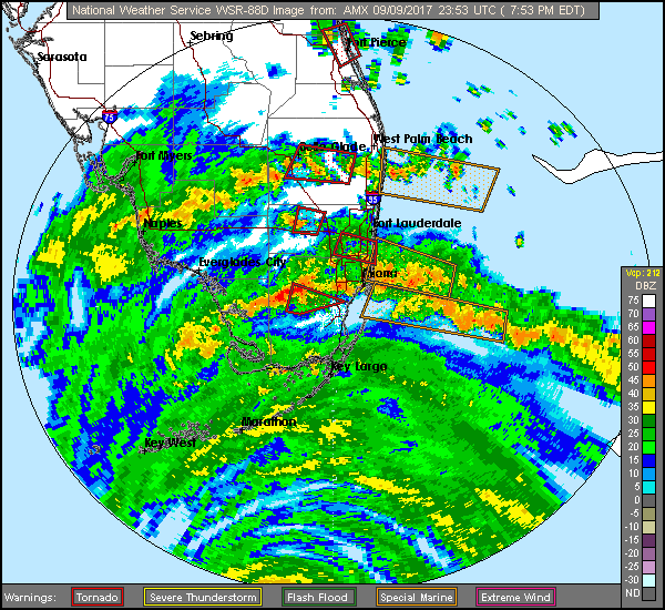
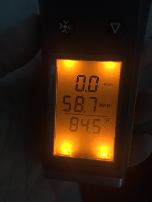
The wind was already picking up in Miami in the early evening.
We just had a 59 mph wind gust in downtown Miami. The wind has really picked up in last 20 minutes. @WPLGLocal10
The winds on Saturday got high enough to send some high-rise construction cranes spinning in circles.
Up to 20 inches of rain is possible through Wednesday across parts of the Florida peninsula and southeast Georgia.
For details and updates about the hurricane in Miami, check the National Weather Service’s page here.