NHC/NOAA Hurricane Maria forecast at 5 p.m. ET from the National Hurricane Center.
Less than two weeks after Hurricane Irma, the Caribbean is facing another major storm with Hurricane Maria. On Monday afternoon, the storm intensified to become an “extremely dangerous” Category 4 storm, with maximum sustained winds at over 130 miles per hour. By 7:45 p.m., it became a Category 5 hurricane. Puerto Rico and the U.S. Virgin Islands are both under Hurricane Warnings already.
The 7:45 p.m. ET update from the NHC reported that Maria is now a Category 5 with maximum wind speeds at 160 mph. It is only 40 miles north of Martinique.
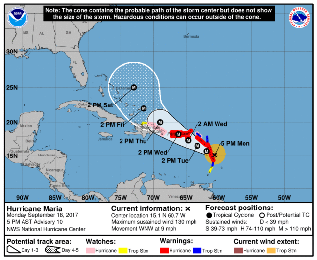
NHC/NOAAHurricane Maria forecast at 5 p.m. ET from the National Hurricane Center.
A Hurricane Watch is also in effect for Guadeloupe, Dominica, St. Kitts & Nevis, Montserrat, Martinique, the British Virgin Islands, Culebra and Vieques. As of 5 p.m. ET, the Maria was moving west-northwest at 9 mph, and was 45 miles east-southeast of Dominica. That’s less than 400 miles away from Puerto Rico. The NHC warns that the storm is already “extremely dangerous,” adding that the eye and intense inner core will pass near Dominica in a matter of hours.
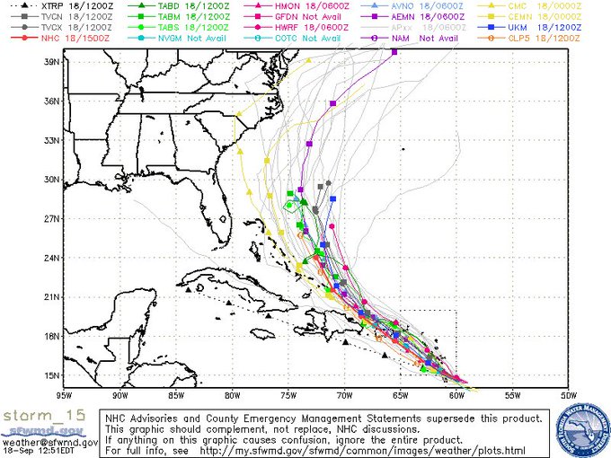
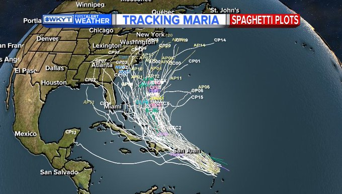
Hurricane #Maria predictive models/spaghetti tracks suggest Puerto Rico & VI to be hit again. FL track appears unlikely but need to monitor

The NHC warns that Maria is starting to develop the “dreaded pinhole eye,” with a diameter of about eight to 10 nautical miles. It is also expecting Maria to grow much stronger as it passes over islands that were already significantly affected by Hurricane Irma.
Hurricane Maria is a Category 3. I have included the NHC Forecast Cone & the Spaghetti plot map of several different models.
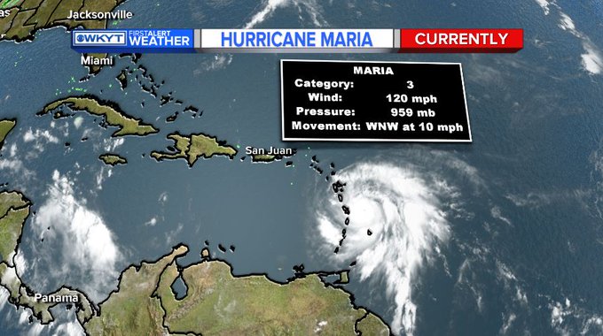

“Atmospheric and oceanic conditions appear favorable for additional rapid strengthening for the next 24 h and possibly longer. The intensity forecast, which is at or above the upper edge of the guidance, now calls for Maria to reach a peak intensity of 135 kt in about 24 h, and it is possible that the hurricane could reach category 5 status,” the NHC notes. For Maria to become a Category 5 storm, it needs to reach maximum sustained winds of 157 mph or more.
The Center also notes that Maria is “likely to affect Puerto Rico as an extremely dangerous major hurricane.” It is also likely to be “extremely dangerous” for the Leeward Islands, the British Virgin Islands and the U.S. Virgin Islands.
The hurricane warning is the higher of the two hurricane notifications issued by the NHC. It means that hurricane conditions are expected within the area within 36 hours. “Hurricane conditions” are considered maximum wind speeds at 75 mph or higher. It’s suggested that residents of areas under hurricane warnings need to be prepared for a coming storm as soon as possible and begin paying attention to statements from government officials.
A hurricane watch means that hurricane conditions are possible within the area. Saba and St. Eustatius, St. Maarten, St. Martin and St. Barthelemy, Anguilla, and Isla Saona to Puerto Plata are all under hurricane watches because of Maria.
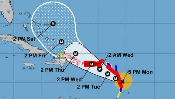
The 5 p.m. ET cone map shows Maria turning north before it reaches Cuba, and reaching the Bahamas by Saturday. It’s still too early to tell if Maria will be a threat to Florida like Irma. According to Reuters, Irma killed at least 84 people in the U.S. and Caribbean.