National Hurricane Center
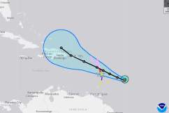
Hurricane Maria is a powerful Category 5 storm with sustained winds of around 155 mph. On Monday night, she ripped through Dominica, leaving several people without power and destroying homes in her path. Maria is currently 85 miles of Guadeloupe, moving west northwest at about 9 mph. She has her sights on the Virgin Islands and Puerto Rico, where she is expected to arrive over the next 24 to 48 hours.
The National Weather Service has issued a hurricane warning for Guadeloupe, Dominica, St. Kitts, Nevis, Montserrat, the U.S. and British Virgin Islands, Puerto Rico, Culebra and Vieques. Meanwhile, a tropical storm warning has been issued for other islands in the Caribbean including Martinique, Antigua, Barbuda, Saba, St. Eustatius, St. Maarten, and Anguilla.
Hurricane watches have been issued in parts of St. Eustatius and St. Maarten, St. Barthelemy, Anguilla and in some of the northern regions of the Dominican Republic.
Tropical storm watches have been posted from west of Puerto Plata to the northern Dominican Republic-Haiti border.
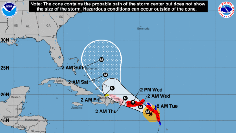
So, where will Hurricane Maria head next? Meteorologists all over the world have been working hard to track Maria, looking at several different models and paying close attention to the advisories from the National Hurricane Center. Although there is a pretty large margin of error over a 5-day period, the GFS and European models have predicted Maria’s track after she leaves the Caribbean, passing just to the north east of the Bahamas as she continues to move west.
Overall, computer models predict that Maria will steer clear of the state of Florida. While that could change, the Sunshine State is collectively breathing a sigh of relief at this point, still recovering from Hurricane Irma.
In the long-term, models are very consistent (Euro included) — keeping Maria well east of Florida.

Below are some graphics from the latest GFS run.

Here is the #GFS looks like for #Maria. Watch the wind field grow as it shoots the gap between #PuertoRico & the #VirginIslands. @WOWK13News
Below are some graphics from the latest European run, which takes place daily at 2 p.m. and 2 a.m.
After #PuertoRico, EURO favors #Maria chasing #Jose out to sea. We know how things can change though, so watching closely. #HurricaneMaria
For those that may be curious about how Hurricane Jose and Hurricane Maria might interact, you can read about the potential Fujiwara Effect here. Also, the graphic below shows a bit more of what could happen over the next 5 to 7 days.
Hurricane MARIA CAT 5 Hurricane JOSE CAT 1 – GFS Track 19th-28th SEP #HurricaneMaria #Maria #HurricaneJose #Jose #EastCoastUS