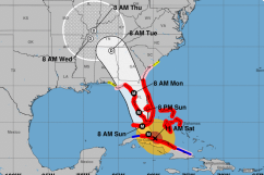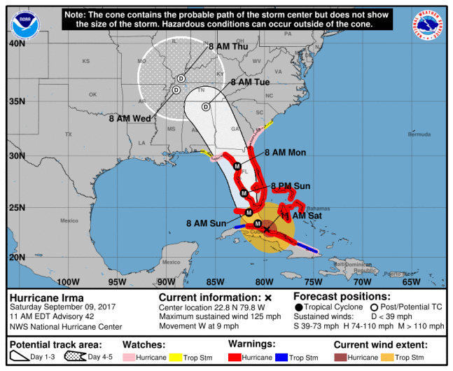
National Hurricane CenterThe latest map of Hurricane Irma as of 11 a.m. on September 9.
Much of Pinellas County has been ordered to evacuate as massive Hurricane Irma approaches Florida.
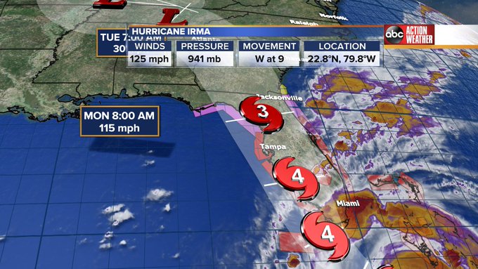
The latest Irma model, released by the National Hurricane Center at 11 a.m. on Saturday, shows the storm shifting slightly to the west, increasing the danger to many parts of Pinellas County. Meteorologists suggest Irma will make landfall as a Category 4 storm in southern Florida around 8 a.m. Sunday morning before working its way up Florida’s spine. It’s expected to impact the Clearwater Beach area the most beginning late Sunday evening into Monday morning.
Updated 11AM track is out. Storm intensity at 125mph. Moving west at 9mph. #Irma
It’s also expected that many parts of Pinellas County and Clearwater will experience increased winds beginning Sunday morning. Check below for a National Hurricane Center wind speed map.
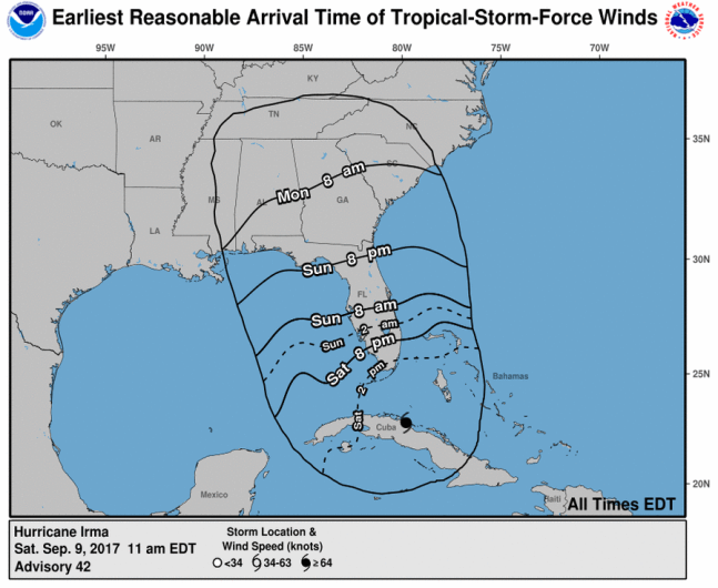
The estimate of when to expect increased winds from Irma.
On Thursday, Pinellas County officials ordered their first evacuation orders and announced they will cut off access to the country beginning at 8 a.m. Sunday. The mandatory evacuation orders apply to level A and B residents in the county, as well as those living in mobile homes.
Click here for additional information on the evacuation orders and to find options available for evacuating.
Here’s the latest weather forecast for Clearwater through Irma, according to AccuWeather:
Saturday: Some sun then turning cloudy and breezy with a thunderstorm during the afternoon. High of 91 degrees with winds from the NE at 16 mph and gusts at 25 mph.
Saturday night: Low clouds and breezy with light showers. Low of 78 degrees with winds from the NNE at 14 mph and gusts reaching 23 mph.
Sunday: Irma approaches and brings heavy tropical rainfall that will lead to flooding. High of around 83 degrees and winds from the N at 47 mph and gusts reaching 70 mph.
Sunday night: Irma comes into the area bringing torrential rain and strong winds. Heavy tropical rainfall will lead to flooding. Low of 74 degrees with winds from the NNW at 61 mph and gusts reaching 116 mph.
Monday: Some wind and rain from Irma. High of 81 degrees with winds from the W at 29 mph and gusts reaching 66 mph.
Monday night: Mostly cloudy with a shower or thunderstorm ant a low of 76 degrees. Winds from the WSW at 7 mph and gusts reaching 23 mph.
For the latest updates on Irma, click here.