National Hurricane Center
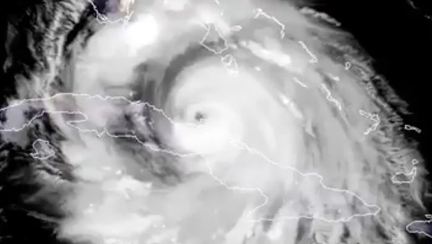
Hurricane Irma, stating the obvious, is causing a great deal of fear throughout Florida and concern throughout the United States.
Where is hurricane now? What’s the current location? There are many credible government and other hurricane tracking sites that you can use to figure out where Irma is in real time. This article provides a list with links of some of the best sites for you to follow, including some of those the news media rely on most.
The monster storm is provoking evacuations across Florida, and the real-time tracking sites recently showed that it had taken an ominous turn to the west. The hurricane is now projected to make landfall imminently. The hurricane, at 2 p.m., was 5 miles from Marco island off Florida’s southwest coast and only 19 miles from Naples. It was expected to make landfall in Naples within the hour.
By 5 p.m., the hurricane had made its second landfall along Marco Island and was five miles from Naples. Hurricane Irma made its first landfall in the U.S. in Cudjoe Key around 9:30 a.m.
However, information is outdated seconds after it’s published with this storm. Thus, here’s where you can go to find out the hurricane’s current location in real time rather than having to rely on articles that might contain old information:
National Hurricane Center
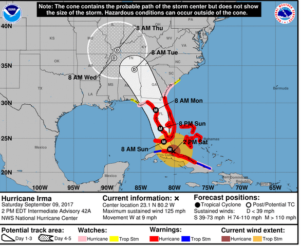
NWSHurricane Irma Saturday afternoon forecast.
The National Hurricane Center is a comprehensive source that the news media rely upon constantly to receive regularly updated information on Hurricane Irma. You can access its site and maps here. Here’s another National Oceanic Atmospheric Administration page with real-time hurricane information. See this page also.
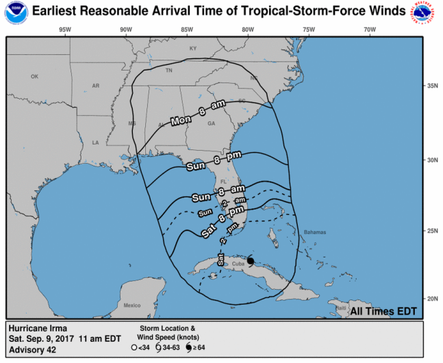
The NHC provides updated time arrival maps like these:
National Hurricane Center
The pages on the link allow you to track things like wind speed, rainfall, arrival time, flood watches, hurricane warnings, and many other data points in great detail. The center also has an interactive map of Florida that allows you to get estimates of such threats. Click on threats and impacts as well as radar and satellite tabs to see great real-time maps and data.
The National Weather Service has a tracking map here.
National Center for Atmospheric Research
This is an educational site that also presents a real-time page on Hurricane Irma that includes spaghetti plots and other up-to-the-minute data points.
The site also tracks other hurricanes, such as Jose and Katia, here. That’s right. There are two other hurricanes brewing out there.
University of Wisconsin-Madison
Governmental entities, and universities, provide some of the best real-time monitoring sources. The University of Wisconsin-Madison has a real-time page of Irma information and maps. Click on the little yellow hurricane icon in the map near the top for Irma to get even more real-time images.
The Weather Underground
Some private sites do a great job giving real-time data. The weather underground has tracking maps that are updated frequently.
Cyclocane
Cyclocane is another a go-to site for updated spaghetti maps on Irma. See other Cyclocane maps here.
South Florida Waste Management District
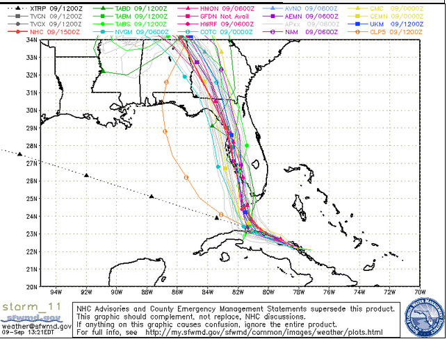
South Florida Waste Management DistrictSpaghetti model for the afternoon of September 9.
This government site has some of the best spaghetti models that people have been sharing (yes, those are the maps that look like noodles thrown on a page). They can provide a good idea of the storm’s projected path, and they were among the first to notice that it was tracking west. You can access the real-time data here.
Local TV & Weather Channel
The news media have some great resources too.
Weather.com has a roundup of real-time maps and trackers for Irma here.
You can also watch live satellite radar and video feeds of Hurricane Irma. You can find live streams of those here: