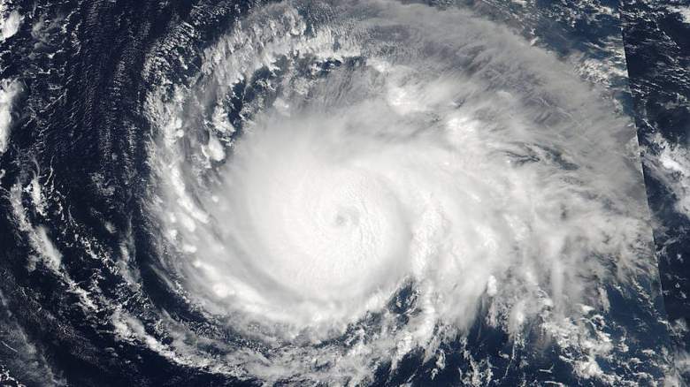
Getty Hurricane Irma from space.
Hurricane Irma is already battering the northern Leeward Islands and is moving closer to Florida. It’s not expected to reach Florida until Sunday, but it is still a Category 5 hurricane. Although latest models show the storm not making landfall at Florida, it is going to make a major impact across the state, including Jacksonville and the First Coast. Here’s a look at the latest forecasts and models.
For a map of evacuation zones, click here.
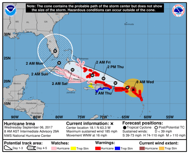
NHC/NOAAThe National Hurricane Center’s map from 8 a.m. AST.
The latest National Hurricane Center track shows the hurricane reaching Puerto Rico today, then making its way to the Dominican Republic and Haiti by Thursday. On Wednesday morning, it made landfall at the Leeward Island of Barbuda.
The storm is projected to spend most of Saturday over Cuba before it turns up towards South Florida, where most school districts have cancelled classes for Thursday and Friday.
This morning, First Coast News reported that some models show the storm bending eastward as it gets close to Florida. However, the storm is so big that it will still leave an impact on the state, even if it doesn’t make direct landfall. The station forecasts that Irma will impact Jacksonville on Sunday into Monday, bringing 4-8 inches or rain, with winds between 40 and 60 mph.
The latest NHC public advisory from 8:00 a.m. AST reports that the storm is still a Category 5 as it passes over St. Martin. Its maximum sustained winds are still at 185 mph.
Florida has in under a State of Emergency since Monday so local governments can prepare for the storm. Governor Rick Scott has ordered all state offices be closed on Friday and suspended all tolls in the state. President Donald Trump also granted Scott’s request for a Pre-Landfall Emergency Declaration. To put together your own disaster plan, click here to go to FloridaDisaster.org/GetAPlan.
Here’s the Jacksonville forecast through Tuesday from the National Weather Service:
Today: A chance of showers, with thunderstorms also possible after 1pm. Cloudy, with a high near 86. Southwest wind 6 to 8 mph. Chance of precipitation is 40%.
Tonight: A 10 percent chance of showers and thunderstorms before 8pm. Mostly cloudy, with a low around 71. Southwest wind 5 to 7 mph becoming west after midnight.
Thursday: Partly sunny, with a high near 85. Northeast wind 7 to 10 mph.
Thursday Night: Mostly cloudy, with a low around 74. Northeast wind 5 to 10 mph becoming light after midnight.
Friday: A 20 percent chance of showers and thunderstorms after 2pm. Partly sunny, with a high near 85. Breezy, with a northeast wind 10 to 17 mph.
Friday Night: A 40 percent chance of showers and thunderstorms, mainly after 8pm. Mostly cloudy, with a low around 77. Breezy.
Saturday: Showers likely and possibly a thunderstorm. Mostly cloudy, with a high near 82. Windy. Chance of precipitation is 60%.
Saturday Night: Showers likely and possibly a thunderstorm. Cloudy, with a low around 77. Breezy. Chance of precipitation is 60%.
Sunday: Hurricane conditions possible. Showers likely and possibly a thunderstorm. Cloudy, with a high near 81. Chance of precipitation is 70%.
Sunday Night: Showers likely and possibly a thunderstorm. Cloudy, with a low around 76. Windy. Chance of precipitation is 70%.
Monday: Showers likely and possibly a thunderstorm. Cloudy, with a high near 82. Very windy. Chance of precipitation is 70%.
Monday Night: A 40 percent chance of showers and thunderstorms. Mostly cloudy, with a low around 74. Windy.
Tuesday: A 30 percent chance of showers and thunderstorms. Partly sunny, with a high near 86. Windy.