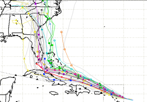
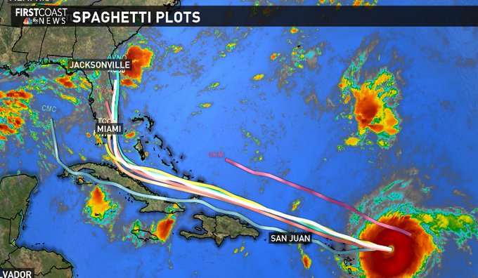
South Florida Water Management District A spaghetti model for Hurricane Irma as of September 5.
Where Hurricane Irma is heading depends, at times, on the model you’re looking at. Spaghetti models literally look like noodles on a map, and the latest ones late on September 7 were not good news for the Carolinas.
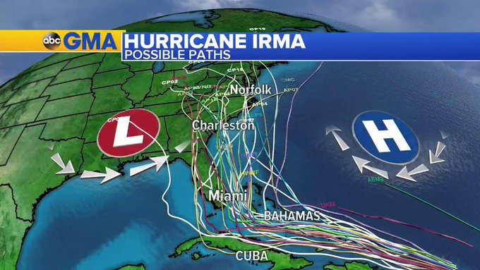
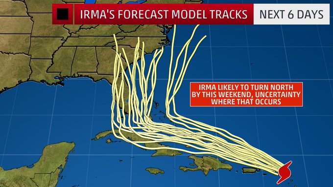
Some of the latest spaghetti plots show Hurricane Irma tracking along the east coast of Florida and then twisting north toward North and South Carolina and Georgia. See this spaghetti model from WTSP-TV. The model shows Irma tracking through Cuba and then up along the east coast of Florida and into Georgia. That’s pretty much held in the most recent spaghetti models. Some of them do show that Florida could be spared the full brunt of the massive hurricane as it continues to shift slightly eastward out to sea, along the eastern coast of the state. Keep in mind that spaghetti models are just projections.
The latest #Irma spaghetti models this morning. #HurricaneIrma #Fox35 #GDO
The question is, if it really does head east, how far east does it go? Out to sea would be good, of course.
More models from September 6 show Florida bearing the hurricane’s brunt with increasing peril to North and South Carolina and Georgia (as opposed to, say, Irma heading over the Gulf.) They’re all estimates, though, and Irma retains an aura of unpredictability (See more of the recent models at the end of this article.)
Here’s the latest spaghetti models. Trending east. Georgia, Carolina Coast need to be on high alert. (As always this could change)
The South Florida Water Management District has an updated Hurricane Irma spaghetti model page.
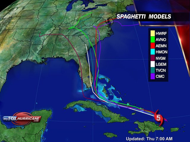
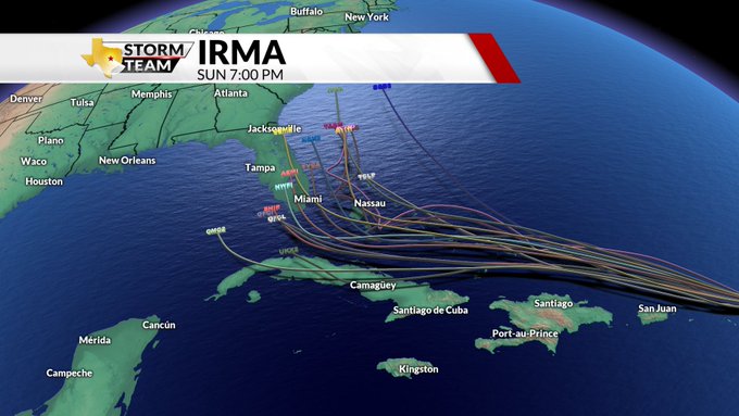
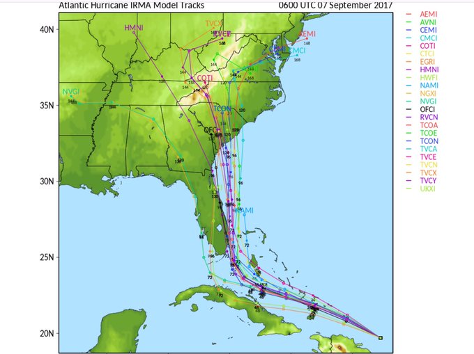
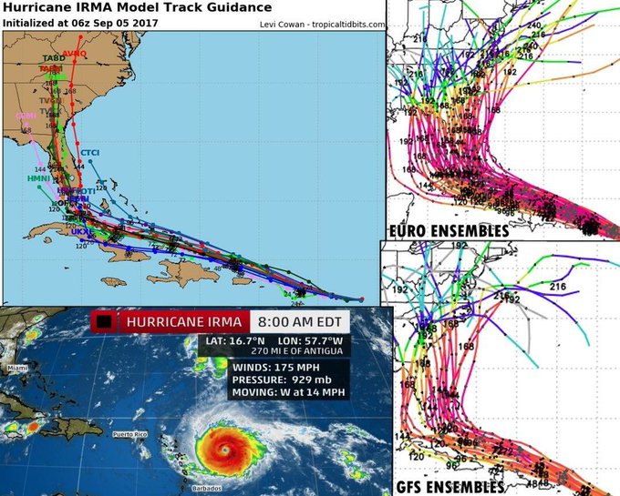
Here’s the spaghetti model for the morning of September 7:
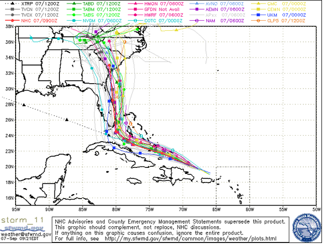
South Florida Waste Manegement DistrictThursday morning spaghetti model.
Here’s the spaghetti model for the evening of September 6:
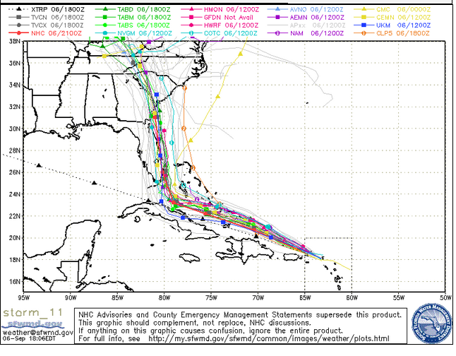
South Florida Water Management DistrictA September 6 evening spaghetti model.
Here’s what it showed on the morning of September 6: A definite eastward turn with South Carolina in peril as well as Florida.
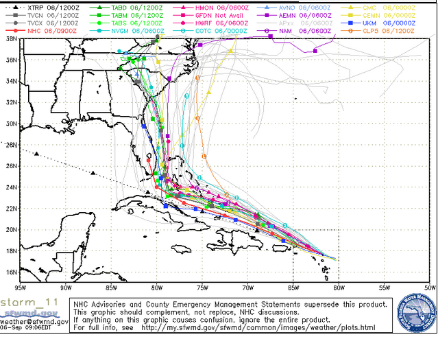
Spaghetti model from September 6.
Here’s what it showed as of 10:45 p.m. on September 5.
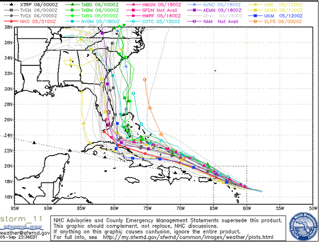
Spaghetti model of Hurricane Irma.
Here’s a slideshow with some of the recent spaghetti models.
What are spaghetti models? “Spaghetti models (also called spaghetti plots) is the nickname given to the computer models that show potential tropical cyclone paths. When shown together, the individual model tracks can somewhat resemble strands of spaghetti,” reports Cyclocane.
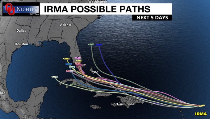
Possible paths for Hurricane #Irma
The site continues: “In short, it gives you a way to see where a tropical storm or hurricane may head. It can also give insight into whether the models are in agreement on the path of the storm (for instance, all models show Florida in the path of a hurricane) or if there is a wide differing opinion on where the storm may go. For instance, in the case of Tropical Storm Debby, the original NHC storm path had her going straight west to Texas, but if you viewed the spaghetti models at that time, you would have had a glimpse into just how uncertain Debby’s path was. Debby’s spaghetti models had her making landfall from anywhere from Texas to Florida to everywhere in between.”
Spaghetti models showing a sharp right turn for Hurricane Irma by Sunday afternoon. #kwkt #hurricaneirma #florida
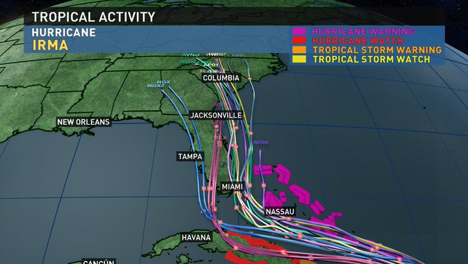
You can see Cyclocane’s latest spaghetti models for Irma here. They also show the hurricane tracking northward to Georgia and the Carolinas, which is disputed by other models, which say Irma could track over the Gulf of Mexico or back to sea. The National Oceanic and Atmospheric Administration (NOAA) National Hurricane Center uses a cone forecast as its dominant model.
8AM CDT 9/7
Latest look at Spaghetti models, cone, satellite and Irma Impacts! Florida to folks up to North Carolina are in play! -HK


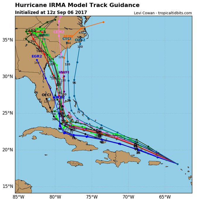
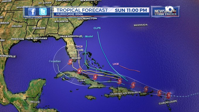
Here’s the NOAA’s cone for the morning of September 7. It doesn’t look as far ahead as the spaghetti models, which is one reason why people in the Carolinas and Georgia are closely watching them in particular. Irma made landfall over Barbuda overnight. Here’s the NOAA page for tracking Hurricane Irma.
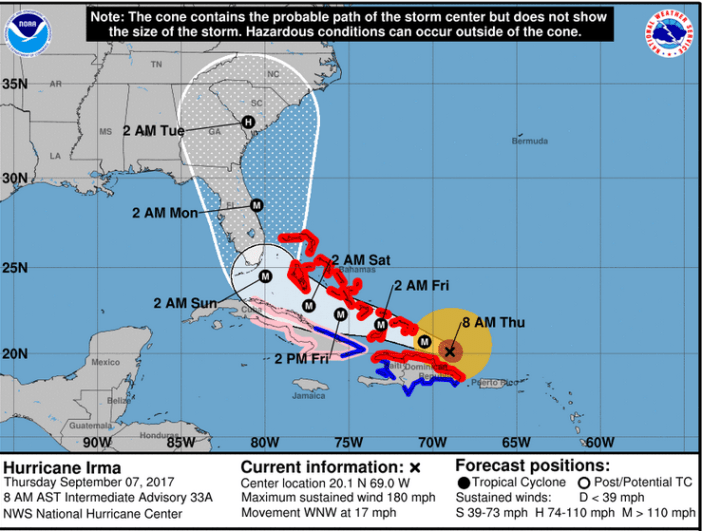
NWSThe Irma forecast cone as of the morning of September 7.
According to WYFF4, “So-called spaghetti models are various storm tracks predicted by computer systems built to make predictions based on historical data.” Explained The Washington Post: “Usually, each ‘strand of spaghetti’ is not representative of a unique model. Instead, the entire bowl of noodles is data churned out by the same weather model. Each noodle is called an ensemble member. When a weather model produces a forecast, it has to initialize the data, taking in current conditions to get an idea of what the atmosphere is already doing on a three-dimensional grid.” The Post notes that the models require estimates that are not always accurate.
The Post article has a September 5 spaghetti model also showing a track up the eastern coast of Florida and then into Georgia and the Carolinas.
Here are more of the latest Irma spaghetti models. A lot of them also show the turn to the east and then the northward path.
The point where #Irma turns north is critical for what Florida, Georgia and the Carolinas can expect. Details: t.co/3FTQ6HZVol
This is not a joke, these are real spaghetti models for Irma #hurricaneirma t.co/DQ1ArWdrvs t.co/fPUm9N7FR4

Some recent spaghetti models have Irma tracking north and possibly even missing Florida.
https://twitter.com/KoltonAvery/status/905240051428335617
And still lots of spread on the spaghetti plot here of the major global and ensemble models #Irma

This is what we call the “Spaghetti Plots” showing different computer models. For what it is worth…a slight shift towards a quicker turn
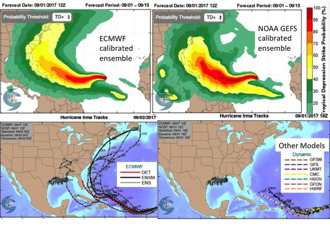
Some clarity emerging from CFAN’s calibrated tracks for Irma. ECMWF: 21% in GoM; NOAA: 32% in GoM
Latest spaghetti models big shift east. Is it legit?

Here are some of the latest spaghetti models🍝 for hurricane #Irma over the next 5 days! A US landfall is not exactly guaranteed. #irmatrack
Latest midday spaghetti models have #Irma as a major hurricane plowing into Florida or turning just off the coast over the weekend.

Latest spaghetti models support the American models that stayed east this morning. So our impacts and timing remain the same for now.
Some people aren’t convinced, as the memes and jokes flew about the models:
Remember life before “spaghetti models?” Category 4 Hurricane Irma

Weather.com notes that spaghetti models can have limitations. “Although most models show possible impacts, to present many models succinctly on a single chart, meteorologists generally produce spaghetti plots that usually only show the ‘where’ and a loose representation of ‘when’ for tropical systems,” the site reported. “To get to this level of brevity, meteorologists must only focus on the center point of a tropical system, which may or may not be accurate. We’ll get to more on that limitation later, but for now, let’s focus on the lack of impacts. These plots do not speak to whether a storm will bring rainfall, hurricane-force winds, surge, or other data; they just contain information about the storm’s future track.”