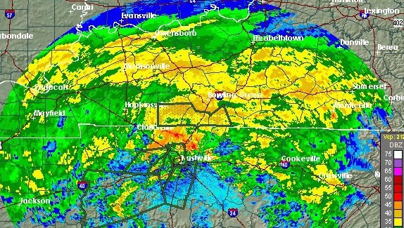
National Weather Service Nashville, TN radar as of 12:30 a.m. on September 1.
Nashville, Tennessee is starting to feel the effects of Hurricane Harvey, which is now a Tropical Depression.
“Tropical Depression Harvey, as expected, pushed into Middle Tennessee Thursday evening, inundating the region with rain and sending creeks rising rapidly — in one case, 13 feet in two hours,” Patch reported.
By later in the morning on September 1, more rain was predicted. “Water rescues are continuing in flooding areas. So far more than 30 people have requested transportation to the @NashRedCross shelter,” wrote the Nashville Office of Emergency Management. “Several roadways are covered in water and unsafe to travel so residents are encouraged to stay off the roads unless absolutely necessary.”
We’re still expecting some additional rain today through Saturday AM, especially north of I-40.

The Weather Service wrote on Facebook at 4 p.m. on September 1: “…brief EF-1 tornado associated with the remains of Hurricane Harvey hit near the Bordeaux community in the northwest part of Nashville at around 1130 PM CDT. It traveled to the northwest and was on the ground for about 2 minutes. The strongest winds were estimated to be around 95 MPH. These winds removed a large portion of a roof from a wood frame house. It also removed shingles from a few homes and collapsed two carports. The tornado snapped or uprooted nearly 100 large mature hardwood trees.”
“The remnants of Harvey resulted in heavy rains and flooding across the northwest part of Middle TN overnight,” The National Weather Service- Nashville wrote Friday morning. By later in the morning, NWS wrote: “Although the heaviest rain has ended, several reports of water rescues along with flooded roads and homes around the Nashville metro early this Friday morning. Flooding will continue for a few more hours before waters recede. Remember, if you encounter any flooded roads, Turn Around Don’t Drown!”
The remnants of Harvey resulted in heavy rains and flooding across the northwest part of Middle TN overnight.
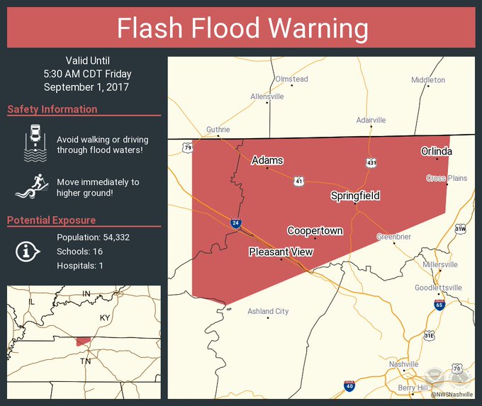
Flash flood warnings were issued.
Flash Flood Warning including Springfield TN, Coopertown TN, Pleasant View TN until 5:30 AM CDT
Here’s how the radar for Nashville looked after 9 a.m. on September 1.
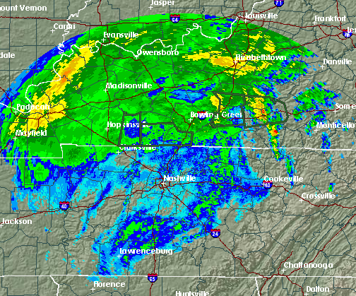
National Weather ServiceNashville radar.
The National Weather Service’s Nashville office warned very late in the evening of August 31, “Very heavy rain is falling in parts of #Nashville metro tonight. If you encounter flooded roadways, remember to #TurnAroundDontDrown!”
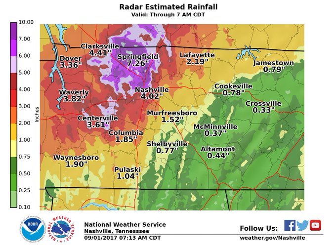
The National Weather Service wrote on August 31 in its Hazardous Weather Outlook for Nashville: “Heavy rain will persist through Friday as Tropical Depression Harvey moves across Middle Tennessee. Forecast rainfall amounts from today through Friday afternoon range from up to 1 inch along the Cumberland Plateau, to 3 to 5 inches across the Nashville Metro Area, to 6 to 8 inches around Clarksville and Land-between-the-Lakes.
Also, areas generally east of I-65 remain under a marginal risk of severe storms on Friday, with isolated tornadoes once again being the primary threat. Winds will increase across most of Middle Tennessee tonight and Friday as the center of Harvey tracks across the mid state. Sustained speeds of 10 to 20 mph will be common, with gusts of 30 mph or greater in many areas, is expected.”
Patch reported that “residents in one North Nashville neighborhood were encouraged to evacuate just after 9 p.m. Thursday” August 31.
You can track Harvey’s movements here. “The remnants of Hurricane Harvey will progress up the Ohio River Valley and the Mid-South on Friday. Heavy rainfall will increase the threat of flash flooding, especially in the Ohio River Valley. There is also a chance of severe thunderstorms, with the possibility of a few tornadoes, in the Southern Appalachians and the Carolinas,” The National Weather Service reported on September 1.
The forecast for Nashville for September 1 read, “Showers and possibly a thunderstorm. High near 70. South southeast wind 10 to 15 mph becoming west in the afternoon. Winds could gust as high as 25 mph. Chance of precipitation is 100%. New rainfall amounts between a half and three quarters of an inch possible.” See a 7-day weather forecast for Nashville, TN here.
See updated radar for Nashville here. Get an hourly weather forecast for the city here.
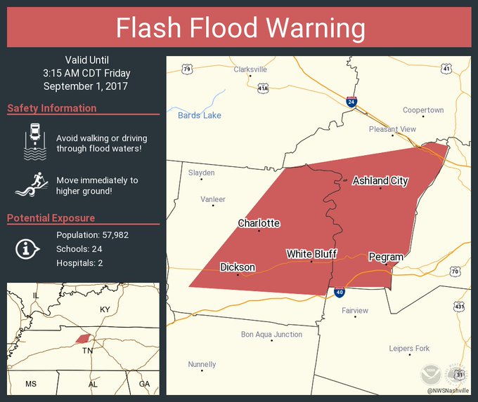
Shortly after midnight on September 1, the NWS issued a Flash Flood Warning “including Dickson TN, Ashland City TN, White Bluff TN until 3:15 AM CDT.”
Flash Flood Warning including Dickson TN, Ashland City TN, White Bluff TN until 3:15 AM CDT
Other flash flood warnings and a tornado warning were also issued. People in Nashville reported on social media that they were hearing tornado sirens.
OHX issues Flash Flood Warning for Cheatham, Dickson [TN] till 3:15 AM CDT t.co/mEZF5MIse7
Tornado Warning including Goodlettsville TN until 12:15 AM CDT

A severe thunderstorm warning was also issued.
Severe Thunderstorm Warning continues for Davidson County, TN until 11:45 PM CDT

Roads were flooded in Hickman County.
21st is entirely impassable with water gushing up out of the middle of the road near Blakemore. Hope my Nashville people stay safe.
There were forecasts that more than five inches of rain would fall.
People posted photos and videos showing the heavy rains.
Ran into this on my way back from @thecadillac3 @TheRyman. West End near Centennial Park. @DanielleBreezy #Nashville #Floods
The scenes were, of course, nothing like the extent of the damage and flooding that Harvey inflicted on Texas, where the death toll is steadily rising.