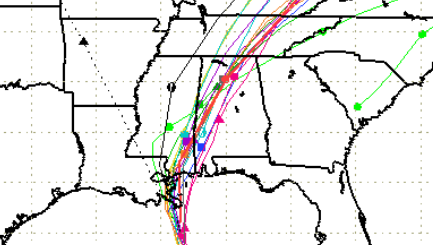
SFWMD Hurricane Nate spaghetti model.
After the triple threat of Hurricanes Harvey, Irma, and Maria, comes news of another major storm, Hurricane Nate.
How strong is Nate? Where is it headed?
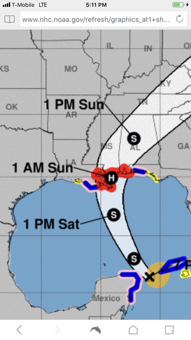
The hurricane is moving on shore at Gulfport, Mississippi according to the forecast cone model used by the National Hurricane Center. A hurricane warning was in effect for New Orleans, Louisiana, raising concerns about flooding.
Nate moving onshore this evening near Gulfport, MS at 28 mph, fastest moving Hurricane in the Gulf of Mexico.

Cyclocane has some of the best, continually updated spaghetti models of Hurricane Nate. You can see those here. They show the hurricane initially threatening New Orleans and parts of Mississippi.
Here’s another view:
Spaghetti models and other forecast plot show concern for New Orleans, Louisiana.
Spaghetti models really tightening up on NOLA, Nate now 50mph and strengthening #HurricaneNate to form in the coming 36 hrs? #severewx

The South Florida Waste Management District also has regularly updated spaghetti models for Hurricane Nate. Here’s the model for the evening of October 7.
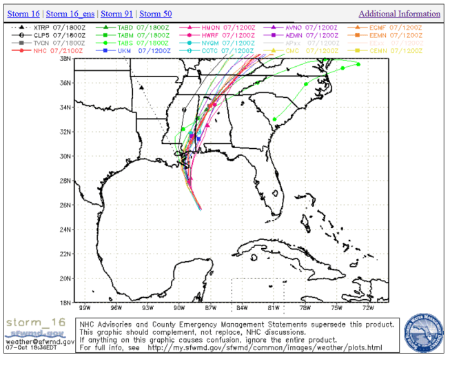
SFWMDSpaghetti Model for Hurricane Nate.
At 4 p.m. on October 7, the hurricane was nearing Biloxi, Mississippi:
SUMMARY OF 400 PM CDT…2100 UTC…INFORMATION
———————————————-
LOCATION…28.4N 89.1W
ABOUT 50 MI…80 KM S OF THE MOUTH OF THE MISSISSIPPI RIVER
ABOUT 140 MI…225 KM S OF BILOXI MISSISSIPPI
MAXIMUM SUSTAINED WINDS…90 MPH…150 KM/H
PRESENT MOVEMENT…NNW OR 345 DEGREES AT 23 MPH…37 KM/H
MINIMUM CENTRAL PRESSURE…981 MB…28.97 INCHES
The ☀️ is peeking out just as #HurricaneNate is about to come on shore.

These are the watches and warnings in effect as of October 7.
SUMMARY OF WATCHES AND WARNINGS IN EFFECT:
A Hurricane Warning is in effect for…
* Grand Isle Louisiana to the Alabama/Florida border
* Metropolitan New Orleans and Lake Pontchartrain
A Storm Surge Warning is in effect for…
* Grand Isle Louisiana to the Okaloosa/Walton County Line Florida
* Northern and western shores of Lake Pontchartrain
A Tropical Storm Warning is in effect for…
* Lake Maurepas
* West of Grand Isle to Morgan City Louisiana
* East of the Alabama/Florida border to Indian Pass Florida
A Hurricane Watch is in effect for…
* Lake Maurepas
* East of the Alabama/Florida border to the Okaloosa/Walton County
Line
The National Hurricane Center reported:
“At 400 PM CDT (2100 UTC), the center of Hurricane Nate was located near latitude 28.4 North, longitude 89.1 West. Nate is moving toward the north-northwest near 23 mph (37 km/h). A turn toward the north and a slight decrease in forward speed are expected during the next several hours, followed by a turn toward the north-northeast later tonight. A motion toward the northeast is expected on Sunday. On the forecast track, the center of Nate will pass near or over the mouth of the Mississippi River during the next few hours, then make landfall along the coasts of southeastern Louisiana or Mississippi tonight. After landfall, the center of Nate is expected to pass over portions of Mississippi, Alabama, and Tennessee late tonight through Sunday night.
Maximum sustained winds are near 90 mph (150 km/h) with higher gusts. Some strengthening is possible before landfall, and Nate could still become a category 2 hurricane on the Saffir-Simpson Hurricane Wind Scale this evening. Rapid weakening is expected after landfall.
Hurricane-force winds extend outward up to 40 miles (65 km) from the center, and tropical-storm-force winds extend outward up to 125 miles (205 km) mainly to the east of the center. The NOAA automated station at Southwest Pass, Louisiana, recent reported sustained winds of 48 mph (78 km/h) and a wind gust of 60 mph (96 km/h) at an elevation of 125 feet. The estimated minimum central pressure is 981 mb (28.97 inches).”