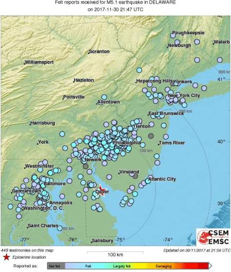
A map showing the cities where a 4.1-magnitude earthquake was felt.
A 4.1-magnitude earthquake occurred in eastern Delaware on Thursday. The epicenter of the quake was along the Delaware Bay, about 10 miles northeast of Dover, and it started at 4:47 p.m., the United States Geological Survey reported.
Tremors and aftershocks could be felt as far west as Washington D.C. and as far north as New York City and Philadelphia, reports on social media suggest. The rare East Coast earthquake hasn’t resulted in any damage or injuries. Its epicenter was near Dover Air Force base, which also said no damage was reported.
#BreakingNews Dover Air Force Base says no reports of injury or damage to government property
#earthquake
“Five seconds of house rumbling, some things shaking … then like nothing had ever happened,” a testimony from a person in Dover on the European Mediterranean Seismological Centre’s website said.
A magnitude 4.1 earthquake centered near Dover Air Force base in Delaware was felt from Washington to Poughkeepsie, New York. t.co/b9CJEtqgsz
See the map above for areas where the earthquake was felt and check below to see the shake map to see its intensity.
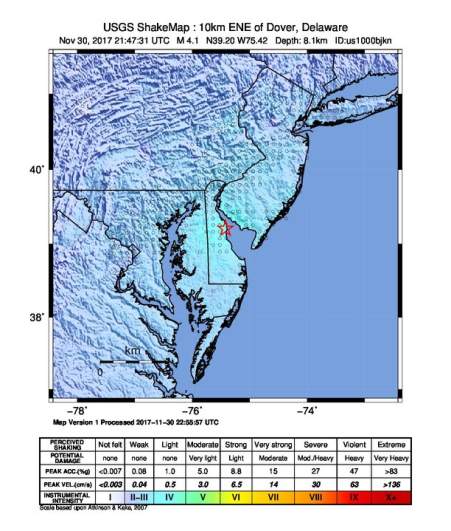
U.S. GeoDelaware earthquake intensity map.
The National Weather Service’s U.S. Tsunami Warning System hasn’t reported any tsunami warning, advisory, watch or threat.
“There is no tsunami danger from this earthquake,” an alert from the center said.
Reports from people on the East Coast surfaced on social media showing the impact of the quake.
@LastQuake Yup felt it in Haverford, Pa… 2 neighbors came running out of their houses.
@LastQuake Felt it all the way in Westchester County!
Earthquake in Atlantic City!
A seismograph showing the #earthquake in the Northeast.
Data: Lamont-Doherty Earth Observatory, Palisades, NY

@DarlaDeMorrow @LastQuake Shook in South Philly for about 30 seconds
USGS Geophysicist Dale Grant told The Washington Post that an earthquake in the Dover area is “exceptionally rare.” Data from the USGS shows there have only ever been three earthquakes of a 4.0 magnitude or higher between D.C. and New York since 1950. The earthquake’s 4.1-magnitude size ties the record for largest in Delaware history, meteorologist Brad Panovich reported.
Unless it’s revised again today’s quake will tie the for states largest with M 4.1 in 1871 . #Earthquake #Delaware
The last notable earthquake in the area was in 2011. That earthquake had a 5.8 magnitude and had its epicenter in Virginia.