Firefighters are battling a 10 acre fire off Old Hwy 395 at Dulin Road, Bonsall (San Diego County). #LilacFirehttps://twitter.com/calfiresandiego
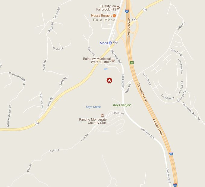
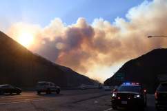
Dangerous wildfires continue to break out in California this week. The Lilac Fire is a vegetation fire that ignited around noon Pacific time on December 7. According to CAL Fire, the Lilac Fire is located off Old Highway 385 at Dulin Road in San Diego County. Within about 30 minutes, the fire grew from 10 acres to over 100 acres. It is currently estimated to be about 4,100 acres with 60 percent containment.
Mandatory evacuations were ordered in the area of W. Lilac Road and Sullivan Middle School. Evacuation warnings are in effect for areas north of Pala Road, south of Reche Road, west of I-15 Freeway, east of Green Canyon Road and W. Mission Road.
There have been three evacuation shelters set up for residents needing a place to go. They are at Fallbrook High School, Pechanga Casino, and Pala Casino.
So far, two structures have been completely destroyed and 12 others have been damaged, according to CAL Fire San Diego. For those traveling in the area or planning to evacuate, it is important to note that there are road closures at Old Hwy 395 between W. Lilac Rd. & Hwy 76. Additional evacuations and road closures may be announced as the afternoon progresses.
“Helen Gao, San Diego Gas & Electric spokeswoman, said people in areas with outages should expect to be without power for ‘several days.’ ‘We expect that they will be out for several days so we’re asking that they be prepared with flashlights, batteries, and a radio so they can stay informed,'” she told KPBS.
The extremely dry conditions, caused by a lack of rainfall in the southern part of the state, have increased the likelihood of wildfires.
“This year … no rain came in September, October and November in Southern California. So we have incredibly desiccated dry fuels,” said CAL Fire’s Tim Chavez.
In addition to the arid conditions, strong gusty winds have fueled these blazes, causing them to grow at a rapid pace. Firefighters are having a very hard time keeping up with the flames.
The National Weather Service has issued “red flag warnings” for Los Angeles and Ventura Counties. These warnings are in effect through Saturday.
“The strongest and longest duration Santa Ana wind event we have seen so far this season will continue through at least Saturday. Damaging wind gusts of 45 to 65 mph will continue today across wind prone areas of Los Angeles and Ventura counties, with slightly weaker winds tonight into Saturday. These Santa Ana winds combined with humidities in the teens and single digits, along with very dry fuels, will continue to bring an extended period of critical fire weather conditions to much of Los Angeles and Ventura Counties. If fire ignitions occur, there is a high likelihood of very rapid fire spread, long range spotting, and extreme fire behavior. Other potential impacts today include downed trees and power lines, blowing dust and debris, as well as power outages,” read the warnings, in part.
Other fires in Southern California include the Thomas Fire, which has engulfed 96,000 acres so far, the Creek Fire, located in Los Angeles County, which has seen 12,500 acres burned, and a third fire, Santa Clarita’s Rye Fire, which has grown to over 7,000 acres. Additionally, the Skirball Fire, affecting homes in the Bel Air and Brentwood neighborhoods, has consumed over 50 acres. All of these fires have caused hundreds of evacuations. To date, thousands of people have been displaced.
Wild animals in the area have also lost their homes, many losing their lives in these fires as well. People who live outside of the fire areas are asked to leave buckets of water outside to help hydrate wild animals who may be passing through. Additionally, residents are asked to keep their pets indoors to ensure their safety.