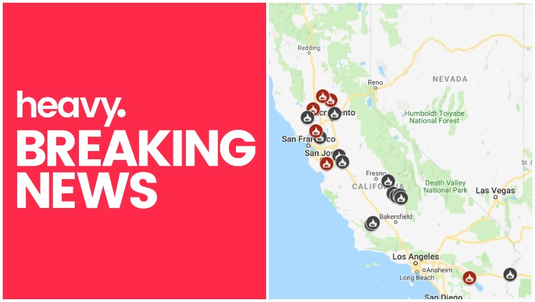
Cal Fire California Fire Map
Fires in California continue to be an issue this season, with high winds and hot temperatures helping fuel the flames. Yesterday, a Six Flags in California was temporarily evacuated due to a nearby fire which is not quite 100 percent contained yet, and evacuations are still in place for the Sand Fire. What is the current condition of fires in California? Read on for more details about fires around the state. News on the fires is constantly changing, so keep an eye on your local news too.
This article first includes interactive maps for all of California. Then the second section details specific fires in the region. If you’re looking for a specific fire scroll down or search for the fire’s name or your city’s name. For details on the Six Flags fire, search for the Sky Fire (its official name.) A new fire has also started in Concord, California. Search for “Concord Fire” for that fire, since it does not have an official name yet.
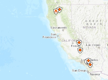
Interactive Map of California Fires
This map below is an interactive map of the more significant fires in California, consistently updated and provided by CAL FIRE and Google. Fires in red are active and fires in black are contained. If the map doesn’t show below, just go here.
Here’s Inciweb’s map. See the full map here.
InciwebCalifornia Fire Map
Next are more specific details on the fires for June 10, 2019. If you are looking for a specific fire, search for the name so you can find it faster, or just scroll down and look at the fires, listed in alphabetical order.
List of Active Fires in California
Here are the active fires and updates about them. Most of these are in alphabetical order, except the Los Angeles fire which is listed first.
66 Fire
The 66 Fire is off Avenue 66 in Thermal in Riverside County. It’s 77 acres as of the end of May and still listed on Cal Fire’s map. It was first reported on May 29 and was 75 percent contained as of May 30. Forward progression was stopped. On May 31 the fire was transitioned to the Bureau of Indian Affairs.
Bluff Mesa Prescribed Burn
Listed on Inciweb, this is a prescribed fire to help prevent wildfires from getting out of control.
Cedar Central Prescribed Burn
Listed on Inciweb, this is a prescribed fire to help prevent wildfires from getting out of control.
Concord Fire
SkyFox is over a 10-acre vegetation fire near Willow Pass and Lynnwod Drive in Concord. Structures are threatened, Cal Fire says.
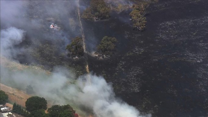
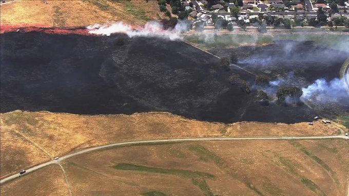
A new fire erupted on Monday, June 10 near Willow Pass and Lynnwood Drive in Concord, California. It’s currently 10 acres but structures are threatened. The smell from the fire has reached Orinda, KTVU shared.
#BREAKING: Brush fire burning off of Willow Pass Road just south of Highway 4 in Concord. t.co/kGJn7dwu1W
The fire is just south of Highway 4.
WATCH: Brush fire off #Highway4 approaches homes near #Concord Naval Weapons Station t.co/GTqpAzv4Wb

The fire is near homes at the Concord Naval Weapons Station.
The good news is that the fire is 80 percent contained after burning 25 acres, KTVU shared.
Kern River Ranger District Prescribed Burn
Listed on Inciweb, this is a prescribed fire to help prevent wildfires from getting out of control.
Levee Fire
Listed by Cal Fire, this is off Highway 20 and E 22nd Street in Marysville in Yuba County. About seven to eight homes were evacuated along Simpson Lane and Levee Road on Saturday, CBS reported. Those evacuation orders were later lifted and the fire is now 100 percent contained. To stay updated on fires in this area, you can listen to the Yuba City and Sutter Counties Fire Dispatch or follow on the Yuba County Wildfire Incidents Facebook page.
Malech Fire
This fire on Malech Road and Bailey Road is in south San Jose in Santa Clara County. It’s 210 acres and 85 percent contained according to Cal Fire on June 10.
Nelson Fire
This fire is off Cordelia Road and Link Road in Fairfield in Solano County. It’s 25 acres and 50 percent contained. Here’s the location on a map:
#RT @CAL_FIRE: New Incident: #NelsonFire off of Cordelia Road and Link Road in Fairfield in Solano County is 25 acres and 50% contained. Lead agency: @Fairfieldfire.
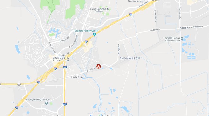
Updates have not been issued for the fire recently, but it is still listed on Cal Fire’s map.
Sand Fire
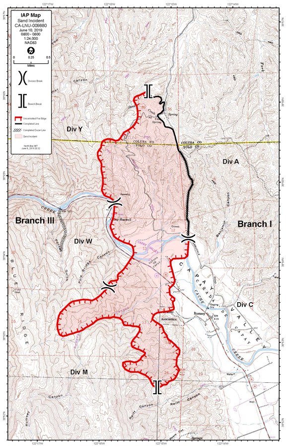
CalFireSand Fire
Listed by Cal Fire, this fire is off County Road 41 and Highway 16 in Rumsey in western Yolo County. It was 125 acres on June 8, but has since grown to 2,200 acres. There was no growth overnight, which is a good sign. The fire is 30 percent contained.
It was first reported Saturday at 2:37 p.m. North winds are helping the fire grow. Highway 16 at Guinda was closed off because of the flames, Sacbee reported.
The cause is unknown. It’s several miles north of areas where PG&E shut down power earlier on Saturday. According to Cal Fire on June 10 at 10:53 a.m.: “Firefighters are currently working a wildland fire in the Capay Valley near the town of Guinda. The fire was reported at a rapid rate of spread and is on steep brush covered slopes. Weather in the area is expected to be hotter with gusty winds up to 20 mph.”
Evacuations are still in place for the County Road 41 area. An evacuation map is here and embedded below.
Shasta Trinity Prescribed Fire
Listed on Inciweb, this is a prescribed fire to help prevent wildfires from getting out of control.
SHF Lightning Fires 2019
A series of small forest fires have ignited in the Shasta-Trinity National Forest area, caused by lightning. Here’s the incident list from Inciweb:
- 06/04/2019 15:13 PORTER Lat, Lon – 41 3.876, -122 38.454 Geographic – S of Bonanza King north of Trinity Lake, 3 acres, Controlled 06/06/19 1450
- 06/03/2019 17:42 GROUSE Lat,Lon – 40 24.882, -123 22.068 Geographic – NW of Forest Glen on the Trinity River Management Unit, .25 acreage, Declared out on 06/05/19 0856
- 06/03/2019 17:24 DEVIL Lat,Lon – 40 18.888, -123 17.484 Geographic NW of Horse Ridge on the Trinity River Management Unit, 0.10 acres, Declared out on 06/07/19 1344
- 06/03/2019 14:48 PICKETT Lat,Lon – 40 21.486, -123 23.172 Geographic SW of Forest Glen on the Trinity River Management Unit, .34 acreage, Declared out on 06/05/19 at 1230
- 06/02/2019 16:44 RUSH Lat,Lon 40 49.596, -122 51.330, Geographic between Tannery Gulch and Hwy 3 on the Trinity River Management Unit, 01 acreage, Contained 06/03/19 2132
Sky Fire (Six Flags Magic Mountain Fire)
#SkyFire *UPDATE* @LACOFD Firefighters made significant progress last night boosting containment to 70%. The total size of the Fire is now estimated to be at approx. 100 acres. LA County hand crews assisted by a @CALFIRE_PIO type 3 Engine strike team will continue mop up today.
A brush fire in the Santa Clarita area caused evacuations to be issued for Six Flags Magic Mountain on Sunday. The fire has been 70 percent contained, KTLA 5 reported. It started around noon on Sunday near The Old Road and Sky View Lane, about a mile from the park, and burned to about 100 acres.
Stuhr Fire
#StuhrFire 🔥 unofficial update: 600 Acres. 75% Contained*.
#StanislausCounty Santa Clara Unit; Near Newman, CA. ~39mi E of San Jose, CA. See officials for safety info. May be incorrect; disclaimers in images.
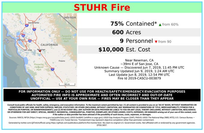
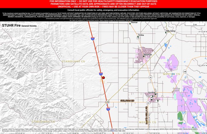
This fire, listed by Cal Fire, was off Interstate 5 and Pete Miller Road, southwest of Newman in Stanislaus County. It’s 600 acres and now 100 percent contained. Updates can be found on the Stanislaus County Wildfire Incidents Facebook page.
Thomas Mountain Prescribed Burn
Listed on Inciweb, this is a prescribed fire to help prevent wildfires from getting out of control.
West Butte Fire (Sutter North Fire)
#RT @CAL_FIRE: New Incident: #WestButteFire off North Butte Rd & West Butte Rd, northeast of Colusa in Sutter County. Lead agency: Sutter County Fire Department
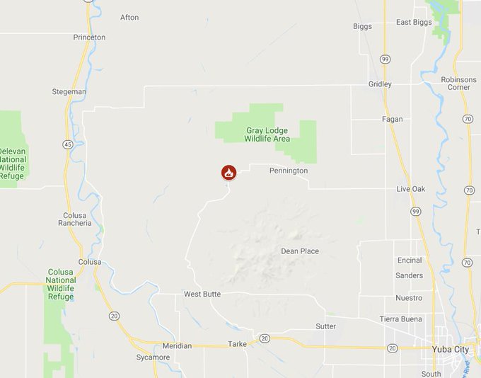
Listed on the Cal Fire map, this fire is off North Butte Road and West Butte Road, northeast of Colusa in Sutter County. It started June 8, 2019. Follow the Sutter County Facebook page for updates. The last update was posted the evening of June 8, noting that the fire had grown to 950 acres and was 60 percent contained.
However, on June 9 and update was shared that the fire had grown to 1,300 acres and was 80 percent contained. It is also called the Sutter North Fire.
This is a developing story.