
Inciweb California Fire Map Near Me
Large wildfires in California are a serious issue again in the state, as Red Flag conditions move back into the West Coast region. Here’s a look at the wildfires in California on October 25, including the Kincade Fire, the Tick Fire, the Sawday Fire, the Walnut Fire in Rosemead, and the Miller Fire in Valley Center, along with Red Flag warnings and air quality reports. You can see a live stream for the Miller Fire later in this story.
UPDATE: For the latest California fire updates for October 26-27, please see Heavy’s weekend fire story here.
This article will first include interactive fire maps for all of California, including Cal Fire and other sources. You can use these maps to track reported fires in your area. The second section will include air quality reports and Red Flag warning maps. Then the third section details specific fires in the region in alphabetical order.
If you’re looking for a specific fire, scroll down to that section or search for its name. Details like evacuations can change quickly, so stay tuned to your local news sources. When available, the sections on specific fires will also mention who you can follow for the latest updates.
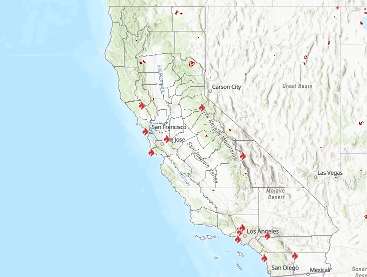
Interactive Maps of California Fires
A number of interactive fire maps below can help you stay updated on the latest details about California fires. Don’t rely on just one map, since details can change quickly and some maps will have fires listed that others do not.
One of the best interactive maps available right now is Inciweb’s map. You can see the full map here. There’s an embeddable Google Map that includes Inciweb fires which you can see below. Depending on your browser, you may need to zoom into the map below using the + button within the map or change settings to only show Inciweb fires:
Another helpful interactive map is provided here from Ca.gov. A screenshot is below since the map can’t be embedded, but you’ll want to go to the full map for details, where you can input your address to see the fires near your location.
CA.gov
A new interactive fire map is below, provided by UCANR.edu. Note that this map is only updated up to twice daily, so it may not be not as current as the two interactive maps above. Because of this, you may need to click “OK” on the map below to indicate that you’re not using it for emergency planning.
The California Governor’s Office of Emergency Services also has an interactive map of red flag warnings and new and active fires. The map is here. This map is updated every weekday morning, so it’s not the best for emergency planning but is still informative.
Newer fires may not be listed on the above maps until they’ve been around for a few hours.
Air Quality Map & Red Flag Warnings in California
Next are sources for tracking air quality in California near you. First, you can sign up for Air Alerts in your region here. This is specifically for southern California residents.
You can see a map of air quality reports on AQMD’s page here. You can also view the map below.
Here’s a map of the current Red Flag Warnings in California. This is providing by MappingSupport.com. You can see the full map here.
Next are more specific details on the fires for October 25, 2019 and early morning October 25. If you are looking for a specific fire such as the Kincade Fire, search for the name so you can find it faster, or just scroll down and look at the fires, listed in alphabetical order.
List of Active Fires in California on October 25, 2019
Here are the active fires and updates about for Friday, October 25, 2019. Most of these are in alphabetical order.
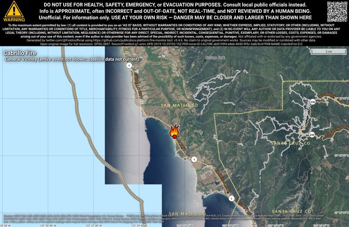
Cabrillo Fire
The Cabrillo Fire was located south of Pescadero in San Mateo County on October 24 near Highway 1 and Gazos Creek Road.
#CabrilloFire 🔥 unofficial, automated update.
~5mi S of Pescadero, CA. ⚠️ DO NOT USE FOR SAFETY PURPOSES – See officials instead. May be incorrect; disclaimers in images.
t.co/1DAaX2sQBJ
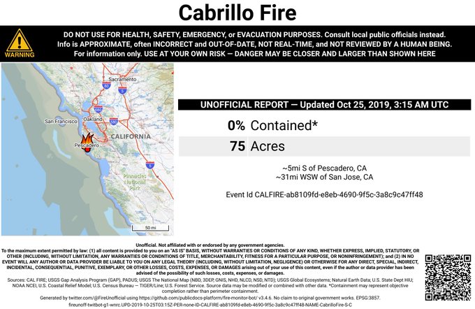
The fire is 95 acres in size and 55 percent contained as of October 25, Ca.gov noted.
The mushroom farm / rave spot two miles from my house is on fire… I’m safe house sitting in Oakland, but I hope everyone on the hill is okay! #CabrilloFire #calfire
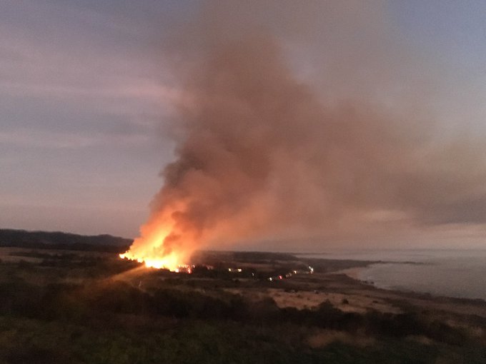
Some residents said it was an old mushroom farm/rave spot.
Caples Fire (Prescribed Burn)
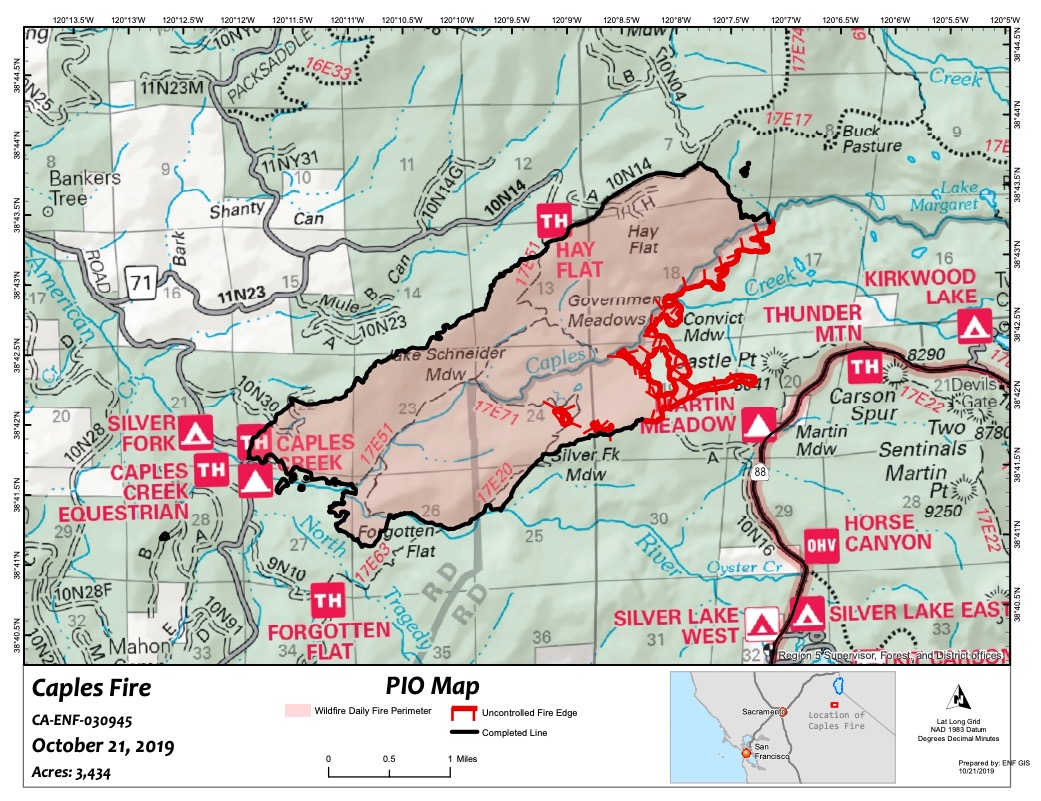
Inciweb
Prescribed burns are purposefully set to help decrease the possibility of unexpected, damaging fires in the future. This one is in the northern ridge region above Caples Creek north of Highway 88.
The fire is 3,434 acres and 80 percent contained as of October 24, according to Inciweb. It’s still within the planned prescribed burn project area. On October 10, this was converted from a prescribed burn to a wildfire to allow for additional resources to maintain full suppression.
On October 24, Inciweb noted: “The containment lines held through last night’s wind event with some interior burning remaining. There is a line around the fire. Crews continue suppression repair, cleanup, and patrolling activities. The containment will be re-evaluated after this weekend’s wind event. This southeast section of the fire is in a roadless area in the Caples Creek drainage. The area is predominately rocky terrain with islands and stringers of vegetation and timber. As there are no changes in the fire perimeter, a new map was not created for today. The Caples Fire is being managed by a Type 4 organization.”
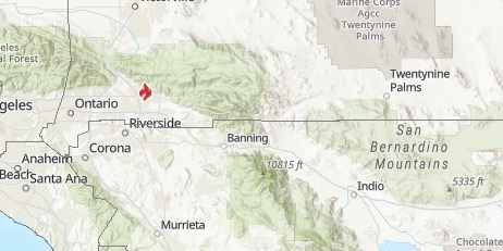
Johnson Fire
CA.gov
This fire in Riverside County is 75 acres and now 90 percent contained as of the latest update from CA.gov. It’s on the Torres-Martinez Indian Reservation and started on October 14. Updates are available here from Riverside County, but the fire has now been turned over to the Bureau of Indian Affairs. It’s still listed as active on Ca.gov’s website.
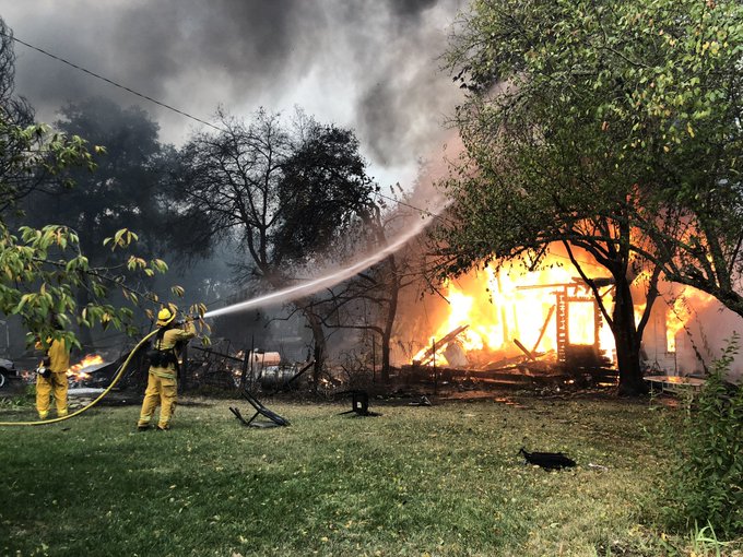
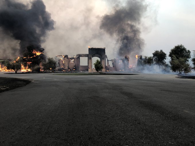
Kincade Fire
CA.gov
The Kincade Fire (spelled Kincaid in some hashtags) is one of the larger fires at the moment. It started on October 24 around 4:26 a.m. near John Kincade Road and Burned Mountain Road, just northeast of Geyersville, according to CA.gov. It’s now 21,900 acres in size and 5 percent contained as of October 25 at 9:30 a.m.
A satellite hotspot map is below provided by MappingSupport.com. This is not a real-time map, but shows where the fire burned about three hours ago.
Evacuations:
The map above is an evacuation and road closure map provided by Sonoma County. See the full map here.
Friday morning update:
Evacuation orders still in place. #kincadefire is at 21,900 acres with 5% containment. This morning’s view from Geysers Rd looking south.
Mandatory evacuation orders include:
- The community of Geyserville
- Cloverdale Geysers Rd, Geysers Rd, Red Winery Rd, Alexander Mountain Rd, Pine Flat Rd, All roads east of Hwy 128 to Geyserville
The following evacuation centers are open:
- Healdsburg Community Center – 1557 Healdsburg Ave, Healdsburg (Currently accepting evacuees) Parking is available for livestock trailers
- Santa Rosa Veterans Memorial Building – 1351 Maple Ave, Santa Rosa, CA 95404 (Currently on standby, please go to Healdsburg Community Center if possible)
- Sonoma County Fairgrounds – 1350 Bennett Valley Rd, Santa Rosa. This is currently open to large animals only.
Road closures include: Cloverdale Geysers Rd, Geyser Rd, Red Winery Rd, Alexander Mountain Rd, Pine Flat Rd, All roads east of Hwy 128 to Geyserville. The County of Sonoma later noted: “Expect all roads east of Hwy. 128 from Cloverdale to Healdsburg to be closed due to fire.”
The cause of the fire is under investigation.
KPIX reported that at least six homes were burned near Geysers Road and Red Winery Road.
We have confirmed at least a half dozen homes burned near Geysers Rd & Red Winery Rd. Firefighters are doing their best to save structures. Winds have calmed slightly. We are hoping for an update from CalFire any minute now on the size & containment on the #KincadeFire
@KPIXtv


To stay updated on the fire: The Sonoma County Sheriff’s Office is providing updates on Nixle here. You can also text your ZIP Code to 888777 for mobile alerts. The fire information number is 707-967-4207.
Sonoma Sheriff’s Facebook page is also providing updates, along with the County of Sonoma.
SoCo Emergency is providing updates here.
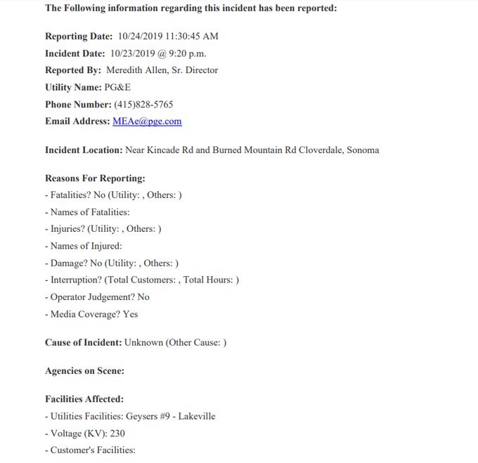
The cause of the fire isn’t known, but a PG&E report to CPUC noted a transmission tower had a broken jumper cable near the site of the fire around 9:20 p.m. on Wednesday.
PG&E report to CPUC says there was a transmission tower with a “broken jumper” cable found around 9:20 p.m. Wednesday near site of #KincadeFire. Documents from CPUC attached t.co/L1Bc3LRihk

Klamath NF Fall RX Burning
These are prescribed burns in the Klamath National Forest area to cut down on damage from unplanned fires.
Martinez 3 Fire
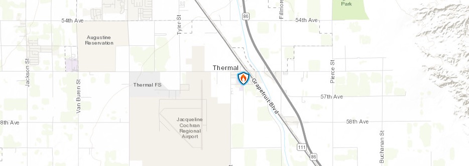
This fire is 31 acres and 50 percent contained as of October 24 at 8:38 p.m. The cause is under investigation. It was on the Torrez-Martinez Indian Reservation. It’s smoldering, creeping, and sometimes actively burning during wind events in mulch piles, Inciweb noted. The fire is in the county of Thermal, California.
Inciweb noted the following planned actions: “Firefighters are working around the clock to put this fire out as quickly as possible; however, the work ahead will take time. Mulch piles are 12-15 feet deep, spread across an area the size of 31 football fields. The mulch requires heavy equipment to feather and spread material so it can be cooled and suppressed by firefighters using hoses. Firefighters anticipate about two weeks of work to complete the extinguish the fire.”
Middle Fire
Inciweb
The Middle Fire is 1,339 acres as of October 6 and now listed as 100 percent contained according to Inciweb. It’s still listed as active on the map. It was located one mile east of Canyon Creek Trailhead and was caused by lightning. It started on September 5 and is in the Trinity Alps Wilderness. “Please be aware that the forest’s Middle Fire Closure Order remains in effect until the fire is declared out.”
Miller Fire in Valley Center
A fire has been reported near Miller Lane and Cole Grade Lane in the Valley Center region. It has heavy fuels and grew to six acres in just 30 minutes. It’s now 10 acres and 0 percent contained as of 2:30 p.m. It was first reported just around 1 p.m. on October 25.
.@CALFIRESANDIEGO is at scene of a vegetation fire near Miller Lane and Cole Grade Lane in the Valley Center area. 6 acres, burning in heavy fuels. #MillerFire
#MillerFire near Valley Center [update] The fire is 10 acres and 0% contained.
Smoke from the fire can be seen from far away.
We can see the fire near Valley Center from our office. It can be monitored via HPWREN webcams as well. #cawx

Some evacuation orders are already in progress for this fire. A live stream for news covering the fire is below.
Evacuations were ordered for people in the region, NBC 7 reported. A temporary evacuation point is at Valley Center Community Center at 28246 Lilac Road.
If you need assistance with large animal evacuations in the #MillerFire area, please call the County’s Department of Animal Services at 619-236-2341.
Staff will be there to help with animals. Roads in the region have also been closed.
Students at the nearby high school are being transported off campus.
For updates on the fire, including evacuation details, follow San Diego Sheriff on Twitter @SDSheriff and @CALFIRESANDIEGO.
Mines Fire
Ca.gov
This fire started on October 24. It’s 50 acres and 60 percent contained according to CA.gov, located southeast of Livermore near Mines Road and Del Valle Road.
Muir Fire in Marin County
#MuirFire Update: 50 acres in size.
No structures are threatened; NO evacuation orders have been issued. Hwy 1 is closed btwn Muir beach and Stinson beach. Use alternative routes. #MarinCounty #WestMarin
This fire is off Highway 1 and Panoramic Highway in Marin County near Stinson Beach. No evacuation orders have been issued and no structures are currently threatened. The fire started in the early afternoon of October 24. Highway 1 is closed between Muir Beach and Stinson Beach on October 25. There are no evacuation orders currently.
The fire is 58 acres in size and is near Slide Ranch and is now 50 percent contained as of October 25, according to Ca.gov.
The fire hotline is 415-473-7191.
Smoke seen in Sonoma County is from the Kincade Fire.
Nelson Fire
This fire started on October 24 in Butte County between Durham and Richvale.
#NelsonFire 🔥 unofficial, automated update.
Near Richvale, CA. ⚠️ DO NOT USE FOR SAFETY PURPOSES – See officials instead. May be incorrect; disclaimers in images.
t.co/Ax0dOBeakc
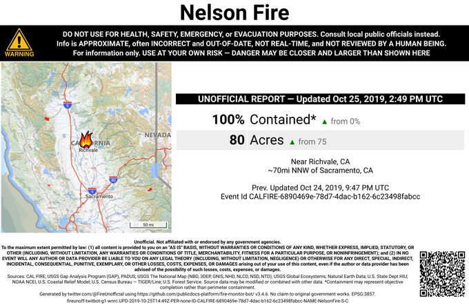

It’s 75 to 80 acres in size, CA.gov noted. It may now be fully contained.
Oak Fire
Oak Fire
This fire started on October 22 near Basilone Road and Las Pulgas Road near Camp Pendleton North, Ca.gov noted. The cause is under investigation.
The fire grew to 140 acres. Suppression efforts are going so well that crews have departed to help with the Tick Fire and the Sonoma Fire.
Old Water Fire
CA.gov
The Old Water Fire started on October 24 around 2 a.m. near Old Waterman Canyon Road and Highway 18, Ca.gov noted. The cause is under investigation. It’s now 105 acres in size and 55 percent contained as of the morning of October 25.
#OldWaterFire 145 ac, 55% contained, all roads open & evacs lifted. Use caution, as fire crews will be in the area building fire containment lines.

Mandatory evacuations were in place until 8 p.m. on October 24 for: Residents on Arrowhead Road, David Way north of 40th street and all connecting streets including Mariposa Drive. Those have now been lifted.
For updates, follow San Bernardino County Fire. Also follow @SanBernardinoNF, @sbcountysheriff, and @SanBernardinoPD.
The fire information center number is 909-383-5688.
Palisades Fire
Ca.gov
The Palisades brush fire in Los Angeles is located near 500 Palisades Drive in the Pacific Palisades. It was first reported on October 21 at 10:39 a.m. It’s 45 acres in size and 75 percent contained as of LAFD’s latest update.
LAFD notes: “We are working vigorously ahead of an anticipated Santa Ana Wind event that is expected to begin Wednesday night through Friday.”
Evacuation orders were briefly in place but lifted by 8 p.m. on October 21. LAFD shared its final update on October 25.
Ramshorn/SHF Lightning Fires 2019
The lightning fires from storms that moved into the area in September are now 100 percent contained and declared out, according to Inciweb.
Saddleridge Fire
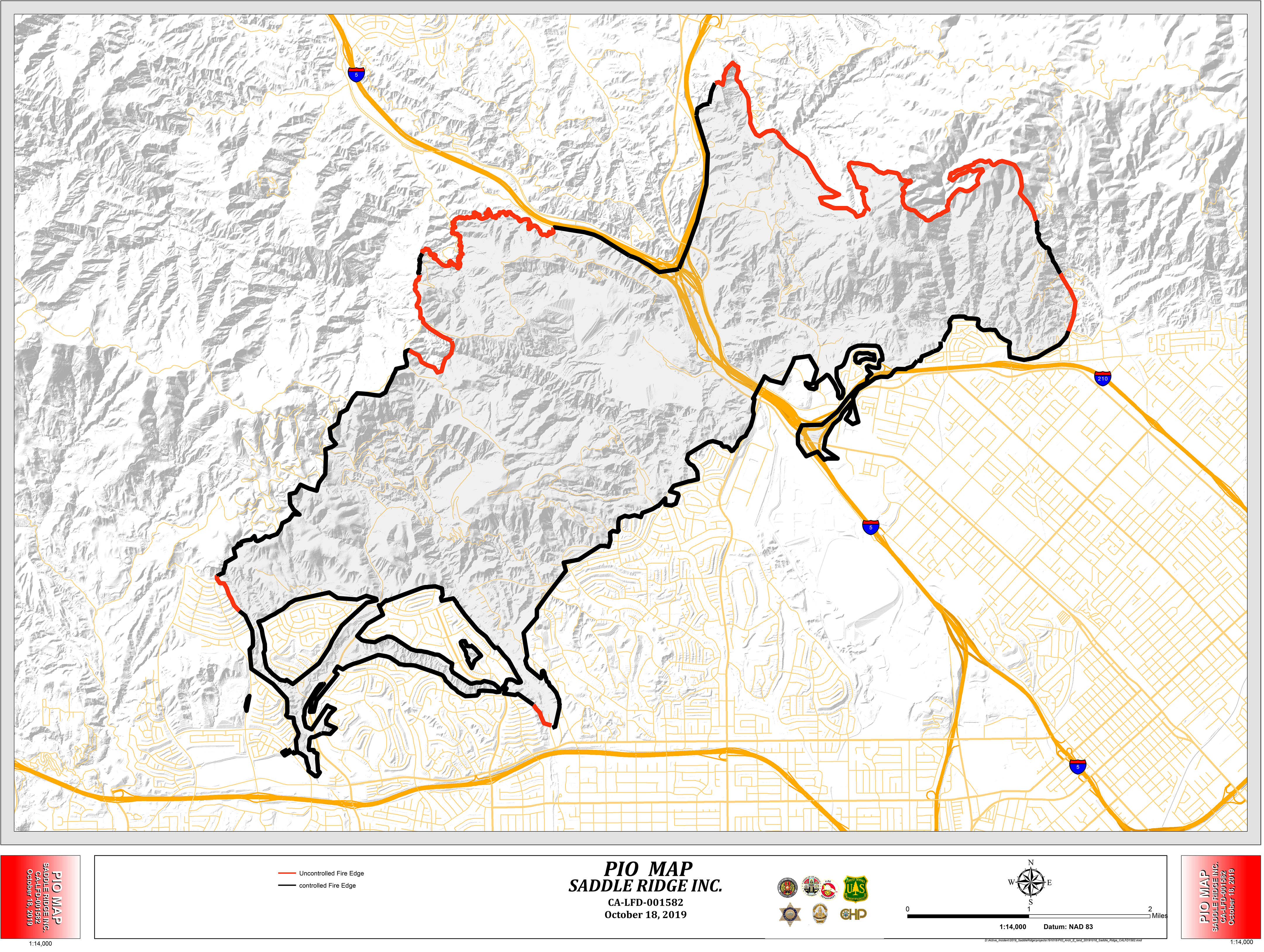
The Saddleridge Fire quickly exploded in size and caused tens of thousands to evacuate, but now it’s under control. Inciweb’s page for this fire is here. The fire is now 8,799 acres in size with 98 percent containment as of October 24 at 9:13 a.m.
It started near I-210 at the Yarnell exit on October 10 around 9 p.m. Pacific. There was one death from this fire: a civilian went into cardiac arrest and died on the way to the hospital. At least 88 structures are destroyed and 19 destroyed.
All evacuations related to Saddleridge have been lifted, LAFD reported on October 15, and evacuation centers have been closed.
The cause of the Saddle Ridge Fire remains under active investigation. Inciweb noted on October 24 that planned actions include: “Continue to strengthen and improve containment line, monitor open line in inaccessible areas, point protection, Continue to manage and support the damage inspection and suppression repair plans. Identify and release all excess resources. Involved agencies are will be operating under single IAP for the operational period.”
Ca.gov won’t be providing further updates after October 23 because of good suppression.
If you live in the LA area, sign up for updates about evacuations and other emergency alerts here: emergency.lacity.org/notifyla. You can also text READY to NotifyLA at 888777 for updates on the fire.
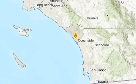
Sawday Fire
This fire was first reported the morning of Friday, October 25, in the area of Sawday Truck Trail in east Ramona. Cal Fire San Diego is providing updates. It’s 70 acres and 0 percent contained as of 11 a.m. with 150 firefighters working on the fire.
The following streets are under evacuation orders:
- Sawday Truck Trail
- Littlepage Rd
- Littlepage Ln
- Old Julian Hwy
- Creek Hollow Dr
- Creek Hollow Rd
The San Diego County Humane Society can help with domestic pets at the Ramona Rodeo Grounds at 421 Aqua Lane (this is also an evacuation point), NBC 7 reported.
Old Julian Highway is closed between Highway 78 and Vista Ramona.
Stay updated on the fire by getting alerts from ReadySanDiego.org.
Sepulveda Basin Fire
A new fire was reported in the Sepulveda Basin region around 4:30 p.m. on October 24. It is about 60 acres in size. The good news is that 80 percent containment was reached Thursday night and now firefighters are looking for areas that may still be smoldering, Daily News reported.
Shasta-Trinity Prescribed Fires
These are prescribed fires in the Shasta-Trinity National Forest area used to mitigate damage from unplanned fires in the future.
Sherman Prescribed Burn
Prescribed burns are purposefully set to help decrease the possibility of unexpected, damaging fires in the future. These are in the Giant Forest area of Sequoia National Park.
South Fire
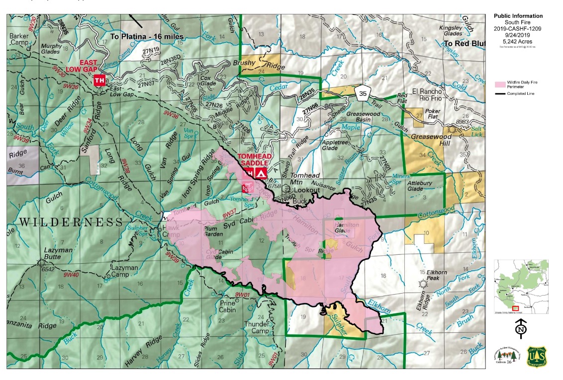
Inciweb
The South Fire started in Shasta-Trinity National Forest in Tehama County, located in the southeast aspect of Tomhead Mountain, south of Platina. As of October 17, the fire was 5,332 acres in size and 75 percent contained, according to Inciweb. That was the latest update for the fire.
The fire is 15 miles south of Platina, California. The map above is the most recent map on Inciweb, but may not quite match the fire’s current size and containment.
Inciweb notes that the plans for this fire are to “Monitor fire activity and patrol existing containment and confinement lines. Complete unfinished repair to Suppression Repair Plan standards. Be prepared to take appropriate action if fire crosses established Management Action Points.”
Sunshine Canyon Landfill Fire
#BrushFire; INC#1041; 2:30PM; Sunshine Canyon Landfill; #GranadaHills; A small 20′ x 20′ brush fire is burning near the Sunshine Canyon Landfill near the 5/14 interchange west of San Fernando Rd. Several spot fires have started … t.co/DCFKHZPDKM
LAFD noted on October 24 that around 2:30 p.m. a small brush fire (20’x20′) was reported near the Sunshine Canyon Landfill, near the 5/14 interchange west of San Fernando Road. No updates have been issued since.
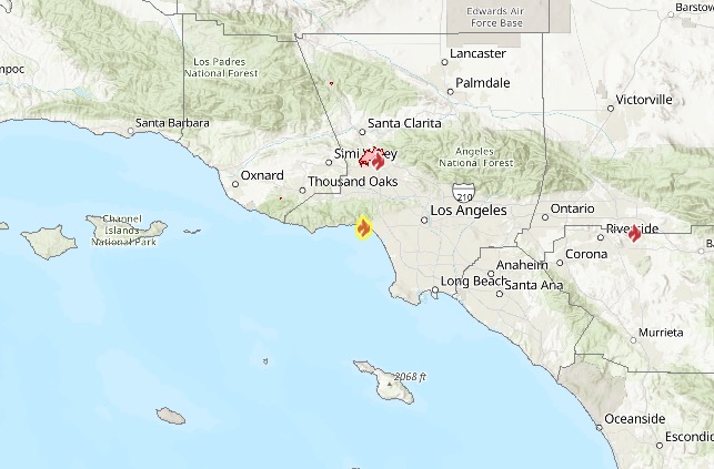
Tick Fire in Agua Dulce
The map above is an official evacuation map from Santa Clarita Emergency.
The map above is an official evacuation map from LA County Fire.
The Tick Fire is now 4,300 acres in size as of 7:13 a.m. on October 25. The good news is that forward progress has been slowed, according to the LA County Fire Department. It’s now 5 percent contained as of 8 p.m. on October 24, and containment was the same by the morning of Ocotber 25. The map above is provided by the City of Santa Clarita.
The danger from the fire is still very real. At 8 p.m. on October 24, LA County Fire warned: “Firefighters are facing a strong Santa Ana wind this evening and into Friday. Approximately 500 firefighters are currently on-scene… As the fire fight continues, we are monitoring the winds throughout the evening as they may increase or change direction and intensify this fire and destroy more homes.”
It just started in Agua Dulce in the afternoon of October 24 and has grown quickly, with at least six structures destroyed.
It was first reported near the 31600 block of Tick Canyon Road around 1:45 p.m. on October 24. It grew to 200 acres in just 20 minutes in Canyon Country. The fire jumped the 14 Freeway around 3 a.m. on October 25.
Mandatory Evacuations:
More than 40,000 residents are under evacuation orders as of October 25.
LA County Fire Department listed the following evacuations:
- All residents North of 14 FrwyE of Whites/Plum Canyon, South of Vasquez Canyon, W of Agua Dolce Also, South of 14 freeway, E of Sand Canyon, N of Placerita Canyon, and W of Robinson Ranch Golf Course. (Listed October 24)
- Also, South of 14 freeway, E of Sand Canyon, N of Placerita Canyon, and W of Robinson Ranch Golf Course. (Listed October 24)
- South of Highway 14, West of Agua Dulce (October 25)
- North of Placerita Canyon (October 25)
- Both sides of Sand Canyon Road (October 25)
- All of Sand Canyon from 14 Freeway to Placerita Canyon Road (October 25)
Voluntary evacuation:
- Fair Oaks Ranch is under a voluntary evacuation.
The latest evacuation updates are on Santa Clarita’s Emergency website here and in the map above that is being updated.
Here are the evacuation centers:
- College of the Canyons main campus in Valencia in the gym. Overnight stays, cots, showers, and food available. (26455 Rockwell Canyon Road in Santa Clarita)
- West Ranch High School (26255 Valencia Boulevard in Santa Clarita)
- Newhall Community Center (this is now closed)
- Large Animal & livestock shelter: Pierce College. (This is now closed, per LA County Fire Department.)
- Castaic Animal Care Center at 31044 North Charlie Canyon Road in Castaic (small animals)
- AV Fairgrounds on 2551 West Ave. H in Lancaster (large animals)
- Pierce College at 6201 Winnetka Ave. in Woodland Hills (animals)
- Call 562-940-6898 for animal evacuation details.
A video of the fire from earlier in the day is below.
LAFD noted that the fire is running downhill and threatening structures.
Some have said that the smoke from the Tick Fire can be seen in Thousand Oaks.
Smoke from the Tick Fire in Santa Clarita visible in Thousand Oaks

How to get updates: The Santa Clarita Emergency Website is providing updates here. You can also get updates by texting SCEMERGENCY to 888777.
LA County Fire is also posting updates on its emergency webpage here.
Taboose Fire
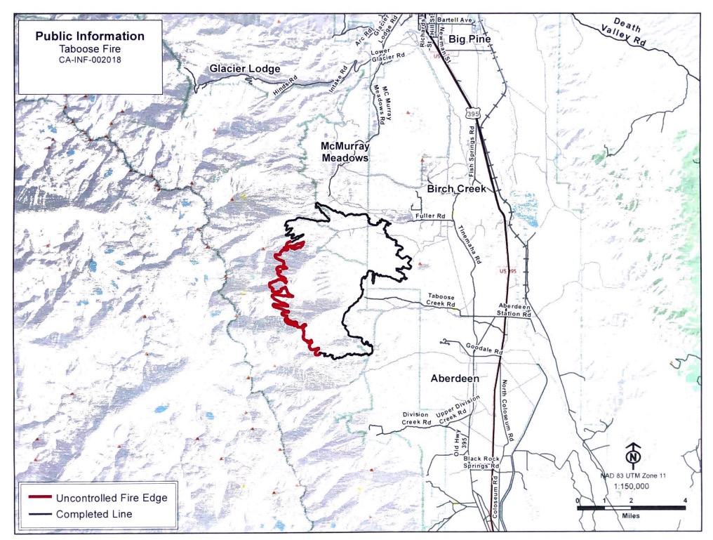
InciwebFire map from September 24, the most recent map
This fire is 10,296 acres and 75 percent contained as of October 7, the most recent update on Inciweb. It’s southwest of Big Pine and northwest of Aberdeen. It was caused by lightning. It’s still listed as active on Ca.gov’s fire map.
Inciweb noted on October 24: “The Taboose Fire has been inactive in recent days. The fire remains 10,296 acres and at 75% containment. The western flank is in steep and inaccessible terrain in the John Muir Wilderness. Here the fire will be confined by either rain or snow or its spread will be stopped by rock barriers. Visitors and residents may see smoke, especially along the Hwy. 395 corridor. Please do not report the smoke. Currently, the south, east, and north flanks are secure and there is no threat to life or property. Visitors and residents will see smoke, especially along the Hwy. 395 corridor. Please do not report the smoke. Currently, the south, east, and north flanks are secure and there is no threat to life or property. Gusty wind and low relative humidity are in the forecast for this week and fire crews will continue to monitor and patrol in areas where the fire is active.”
Walnut Fire in Rosemead
A small brush fire dubbed the Walnut Fire has been reported in Rosemead near Rush Street and Walnut Grove, in the 8600 block of Rush street. It was just reported after noon on October 25.
The fire was reported in the Whittier Narrows golf course in Rosemead.
Just In: A small brush fire is burning near the Whittier Narrows Golf Course in Rosemead. Some resources were borrowed from the #TickFire to battle this one. Updates to come.
It’s about half-an-acre in size according to ABC 7, and a lot of smoke can be seen in the area. Some other reports placed it at about two to three acres in size, but that couldn’t be confirmed.
READ NEXT: PG&E Power Shutdown: Best Memes