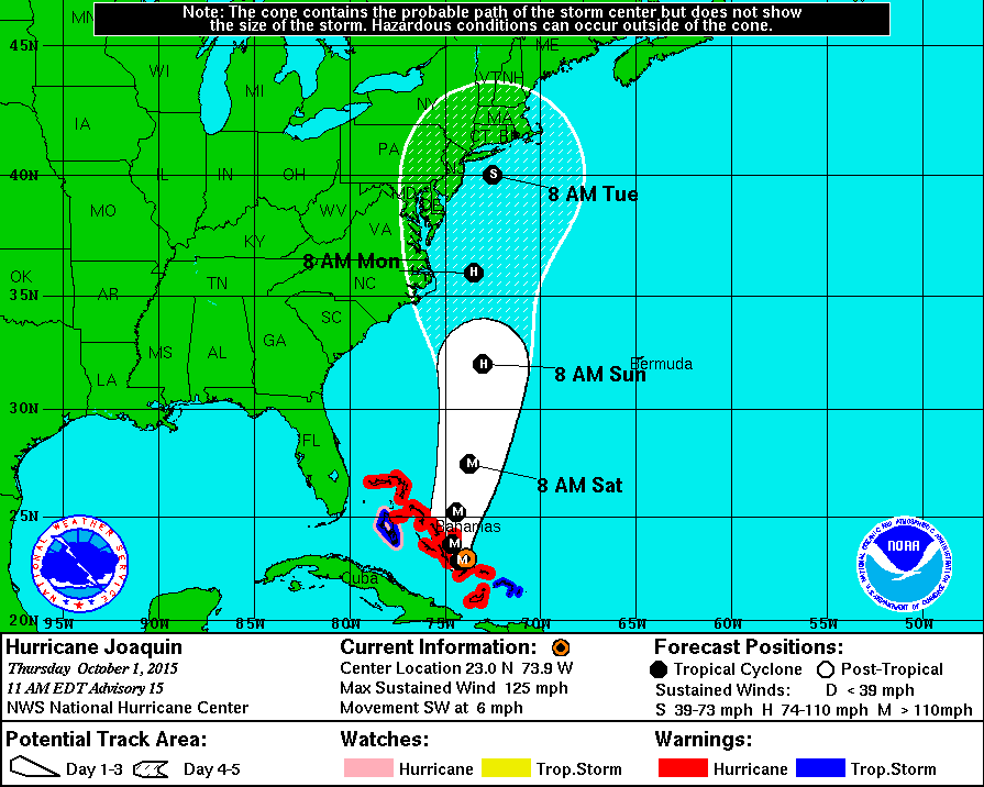
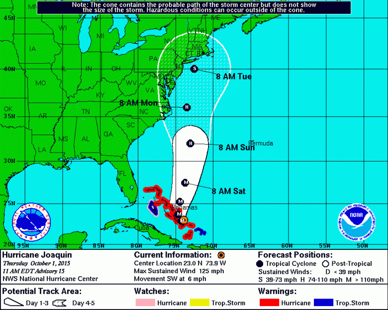
The latest 5-day forecast cone for Hurricane Joaquin. (National Hurricane Center)
Hurricane Joaquin continues to strength in the Atlantic Ocean as it makes its way toward the Bahamas. The latest forecast from the National Hurricane Center puts the East Coast of the United States in the projected path of the powerful storm.
Joaquin could bring historic rainfall to the Carolinas and could also impact the rest of the coastline from the mid-Atlantic to New England, with 65 million people in its possible path. The forecast models are shifting east, meteorologists say, which could spare a direct hit on the United States, but it’s still too early to know exactly where the storm will go.
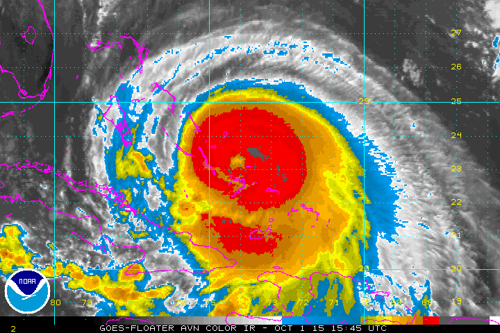
The National Hurricane Center says the storm is currently a Category 3, with sustained winds of 124 mph, and gusts up to 155 mph. It could strengthen into a Category 4 storm.
“Residents of the Carolinas north should be paying attention and monitoring the storm. There’s no question,” Eric Blake, a hurricane specialist at the National Hurricane Center, told the Associated Press. “If your hurricane plans got a little dusty because of the light hurricane season, now is a good time to update them.”
Here’s what you need to know:
1. The Storm Is Causing Severe Flooding in the Bahamas
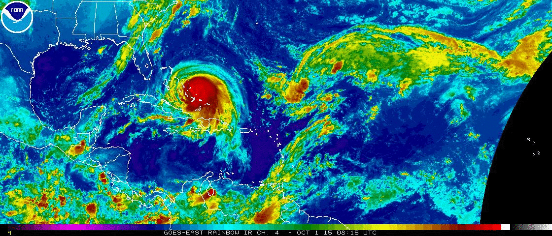
Hurricane Joaquin is currently swirling near the Bahamas. (National Hurricane Center)
Hurricane Joaquin is slamming into central and eastern Bahamas as it moves through the Atlantic Ocean toward the United States.
Hurricane Joaquin already flooding homes on Acklins Bahamas…Live shots…. http://t.co/EfCMuXgiKu
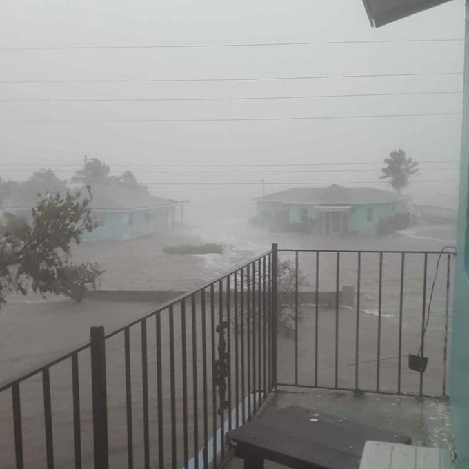
According to the Associated Press, no deaths or serious injuries have been reported. Joaquin has caused severe flooding and power outages, the AP reported.
Read more about Hurricane Joaquin in Spanish at AhoraMismo.com:
2. Joaquin Could Go Out to Sea Before Hitting the United States
Latest spaghetti model plots continue to shift eastward, however, not all models on board with this trend on #Joaquin http://t.co/PQAPupSpyS
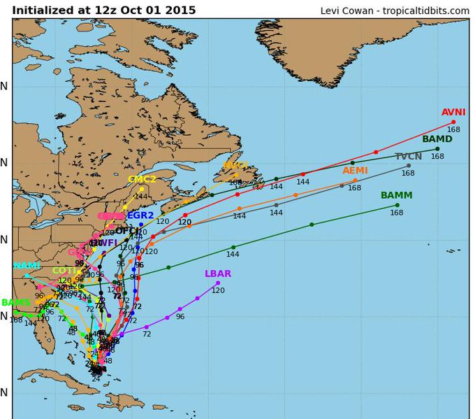
There is still doubt about where Hurricane Joaquin will head as it swirls through the Atlantic Ocean. Some forecast models have the storm turning west toward the Carolinas and mid-Atlantic, with New York, New Jersey and Connecticut also in its path, while others show the storm turning west and out to sea.
“There’s still a distinct possibility that his could make landfall somewhere in the U.S.,” Dennis Feltgen, a meteorologist and hurricane center spokesman, told the Associated Press.
“Confidence in the details of the forecast after 72 hours remains low, as there have been some large changes in the model guidance overnight,” the National Hurricane Center said. “The range of possible outcomes is still large, and the possibility of a hurricane landfall in the Carolinas still cannot be ruled out.”
3. It Is Expected to Bring Heavy Rain to the Carolinas
Whether Hurricane Joaquin turns toward the East Coast or out to the Atlantic Ocean, the Carolinas are expected to see record-setting rain and flooding.
Michael Sprayberry, North Carolina’s emergency management director, said in a statement there is the “potential for life-threatening flooding within the next week. We don’t know yet how much or how widespread the flooding will be, but we know there will be flooding.”
4. The Storm Could Hit New Jersey & New York on Tuesday
(National Hurricane Center)
According to the National Hurricane Center’s forecast, the storm could hit New Jersey and New York on Tuesday. Those states, and others in the projected path, are already starting to make preparations.
New Jersey Governor Chris Christie has declared a state of emergency.
We are prepared. I need everyone to not panic.
“We know there is definitely going to be moderate and likely to be major flooding events in South Jersey Friday and Saturday with 5 to 6 inches of rainfall expected to come,” Christie said Thursday morning at a news conference.
New York Governor Andrew Cuomo said in a statement, “Our state has seen the damage that extreme weather can cause time and time again – and I am urging New Yorkers take precautions for more heavy storms in the coming days. Tropical Storm Lee and Hurricane Irene proved that you do not have to be near the coast to be impacted by Mother Nature. I have directed State agencies to ready their emergency response equipment in partnership with local governments, and I encourage all of our state’s residents to be prepared and stay safe.”
5. Meteorologists Say Joaquin Is a Difficult Storm to Predict
Meteorologists say that Hurricane Joaquin has been a difficult storm to predict.
“The entire meteorological community wants to convey there’s not much certainty,” Climate Central meteorologist Sean Sublette told Time.
“Residents along the East Coast of the U.S. should pay close attention to the forecast now through this weekend. It’s a particularly difficult forecast that hinges on the behavior of several different atmospheric features over North America and the North Atlantic Ocean,” The Weather Channel says. “Computer forecast models – and the meteorologists who use them for guidance – are grappling with a complex interaction between Joaquin, a cold front near the East Coast, the remnants of Tropical Storm Ida, a strong bubble of high pressure aloft over the North Atlantic Ocean, and a potentially strong area of low pressure aloft digging into the southeastern U.S. later this week. Complicating the forecast is the fact a more reliable forecast model keeps Joaquin appreciably away from the East Coast.”