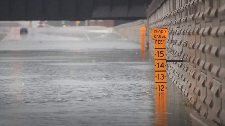
Getty A gauge shows the depth of water a an underpass on Interstate 10 which has been inundated with flooding from Hurricane Harvey on August 27, 2017 in Houston, Texas.
Dramatic Houston, Texas rescues were underway as catastrophic floods hit the city due to Hurricane Harvey, now downgraded to a tropical storm but still dumping inches of water on Houston. People waved for help from rooftops, took to social media, and posted videos of water rising in their homes and apartments in an increasingly dire situation.
What’s the weather forecast for Houston? What are the latest flood reports and radar? Here’s what you need to know, as of the afternoon of Sunday, August 27.
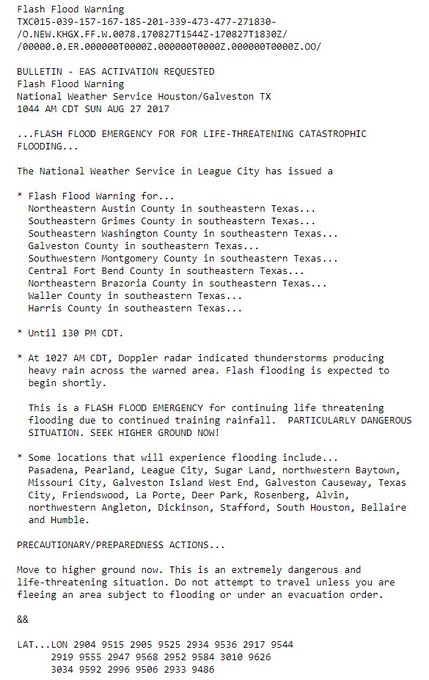
“SIGNIFICANT TO CATASTROPHIC FLASH FLOODING CONTINUES ACROSS PORTIONS OF SOUTHEAST TX, INCLUDING THE HOUSTON METROPOLITAN AREA. THE AVERAGE RAINFALL WITHIN THE HARRIS COUNTY EMERGENCY MANAGEMENT NETWORK HAS EXCEEDED THAT OF TROPICAL STORM ALLISON (2001) IN ALMOST HALF OF THE TIME (2-3 VERSUS 5 DAYS). HISTORIC FLOODING IS EXPECTED TO CONTINUE IN THE HOUSTON METROPOLITAN AREA THROUGH THE FORESEEABLE FUTURE,” the Weather Prediction Center reports. Hourly rainfall totals were up to 3″ with local amounts to 6″ expected.
See up-to-the-minute information on Tropical Storm Harvey from the National Weather Service here.
Look at those PWATs, 3.2″…relentless heavy rains over SE Texas to continue after dark. #Harvey #houstonflood

Get the latest Houston/Galveston forecast information here from the National Weather Service, which wrote, “Catastrophic Flooding across Fort Bend, Harris, Brazoria and Galveston Counties. Life threatening conditions. Emergency services impacted. Water in homes.” Houston was bracing for as much as 50 inches of rain.
See updated radar for Houston/Galveston here.
This is how the radar looked just before 2 p.m. on August 27:
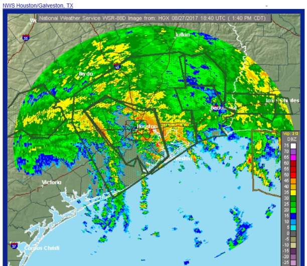
Houston radar at 1:50 p.m. on Sunday August 27.
The local statement from the National Weather Service for Houston read, “A catastrophic and life-threatening flash flooding event is unfolding across Southeast Texas this morning. Many Flash Flood Emergencies have already been issued for the Houston Metro area overnight, some of which remain in effect this morning. Bands of heavy rainfall will continue to drop devastating amounts of ADDITIONAL rainfall across the area over the next several days. Tornadoes have also been occurring across Southeast Texas over the last day or so and will continue through the next several days.”
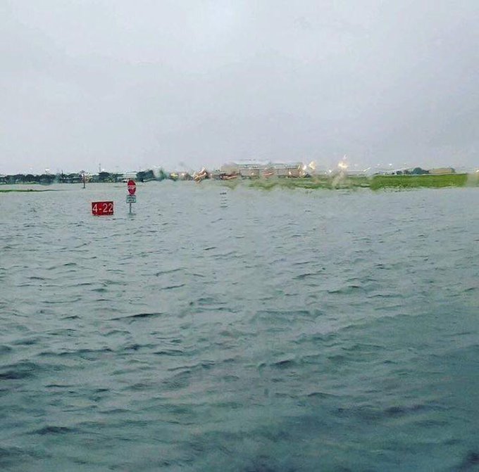
.@HobbyAirport says about 500 people are trapped. A friend shared these pics of a flooded runway and street with @FotiABC13 #HoustonFlood

The statement continues, “Coastal flooding may be an ongoing issue along the coast where winds will continue to push water onshore, particularly south of Sargent. Elevated tides will cause the recession of coastal flood waters to be slow, likely lasting into the first part of the week. Wind gusts to tropical storm force are still ongoing, primarily in the southwestern portions of the area towards Matagorda Bay. Though there are currently multiple hazards present across the area, the greatest threat to life and property remains the ongoing extreme rainfall and subsequent prolonged and catastrophic flash flooding.”
Houston Forecast
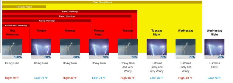
Houston weather forecast as of 2 p.m. on August 27.
Unfortunately, the heavy rains are not expected to let up soon in Houston. See hourly forecasts for Houston here. Here’s the detailed upcoming forecast from the National Weather Service as of 2 p.m. on August 27.
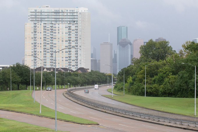
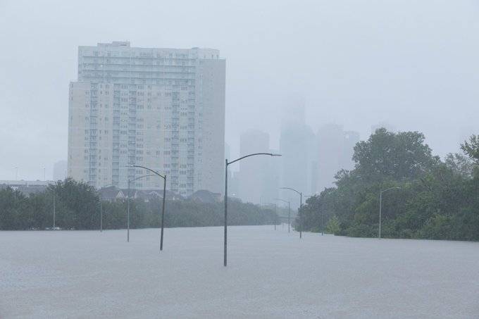
The left is Memorial Parkway on Saturday.
The right is Memorial Parkway Sunday morning.
This Afternoon (August 27)
“Showers and thunderstorms. Some of the storms could produce gusty winds and heavy rain. High near 79. East wind 10 to 15 mph. Chance of precipitation is 100%. New rainfall amounts between 1 and 2 inches possible.”
Tonight
“Showers and thunderstorms. Some of the storms could produce gusty winds and heavy rain. Low around 73. East wind around 15 mph, with gusts as high as 20 mph. Chance of precipitation is 80%. New rainfall amounts between 3 and 4 inches possible.”
Monday
“Showers and thunderstorms. Some of the storms could produce gusty winds and heavy rain. High near 80. Northeast wind around 15 mph, with gusts as high as 20 mph. Chance of precipitation is 80%. New rainfall amounts between 2 and 3 inches possible.”
Monday Night
“Showers and thunderstorms likely. Some of the storms could produce gusty winds and heavy rain. Cloudy, with a low around 73. Northeast wind around 15 mph, with gusts as high as 20 mph. Chance of precipitation is 70%.”
Tuesday
“Showers and thunderstorms likely. Some of the storms could produce gusty winds and heavy rain. Cloudy, with a high near 82. Very windy, with an east wind 20 to 25 mph increasing to 30 to 35 mph in the afternoon. Winds could gust as high as 45 mph. Chance of precipitation is 70%.”
See some of the dramatic photos and videos of the flooding here:
Flash Floods
Flash Flood Warning including Houston TX, Pasadena TX, The Woodlands TX until 7:15 PM CDT
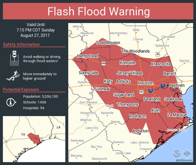
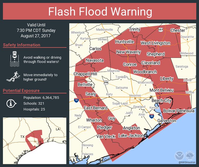
There was a flash flood warning issued at 1:30 p.m. for Houston, Pasadena, and the Woodlands, TX, until evening. There were also flash flood warnings for Conroe, Galveston and Huntsville.
Flash Flood Warning including Conroe TX, Galveston TX, Huntsville TX until 7:30 PM CDT
Major river flooding was forecast for Houston.
Major river flooding is forecast for many locations across Texas due to heavy #Harvey rains. NEVER drive or walk through flood waters!

Horrific photos and videos from the scene showed the desperate nature of the emergency, as people took to rooftops and social media seeking help as their homes flooded.
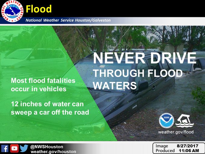
People were advised that it’s dangerous to drive through flood waters.
Driving through flood waters creates a wake that could push the flooding into someone’s home. DO NOT DRIVE THROUGH FLOOD WATERS #txwx
A truck driver was dramatically rescued from his cab. A shocking photo showed seniors sitting flooded up to their waists in a nursing home. The flooding was so bad that one man was videotaped catching fish in his submerged living room.

Tornado Warnings
Tornado Warning including Brookshire TX, Weston Lakes TX, Fulshear TX until 1:45 PM CDT

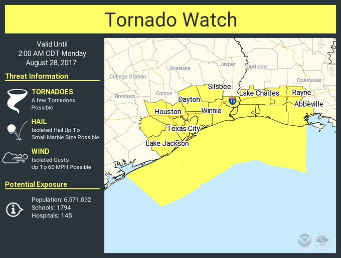
As if the water wasn’t bad enough, people in the area had to endure the fear of tornadoes. There was also a tornado watch issued.
A tornado watch has been issued for parts of Louisiana and Texas until 2 AM CDT
Wind Speeds

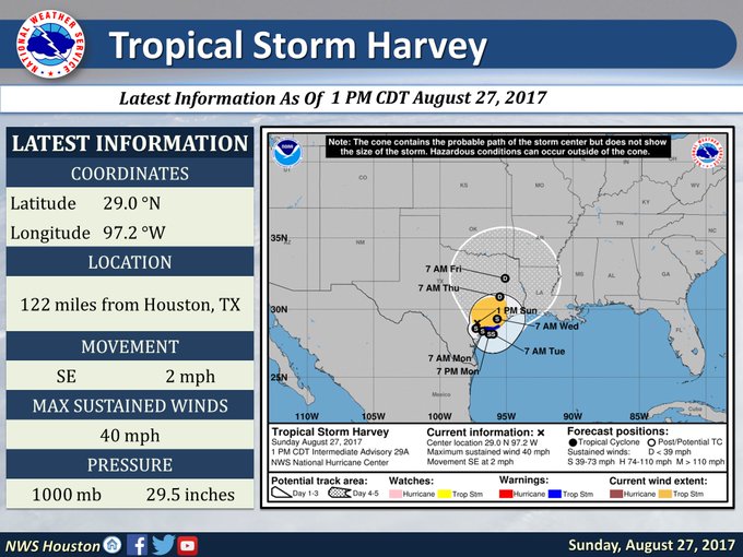
The latest wind speeds on August 27 showed Harvey’s strength was around 40 mph.
Rainfall Totals
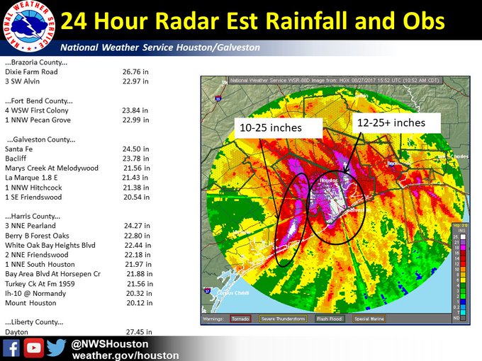
Updated rainfall totals on August 27 showed more than 20 inches of rain had already fallen in some areas. Some parts of the region have already seen more than two feet of rain since the start of the storm, the National Weather Service says. As much as 40 to 50 inches of rain could fall in some areas of Houston, according to the NWS.