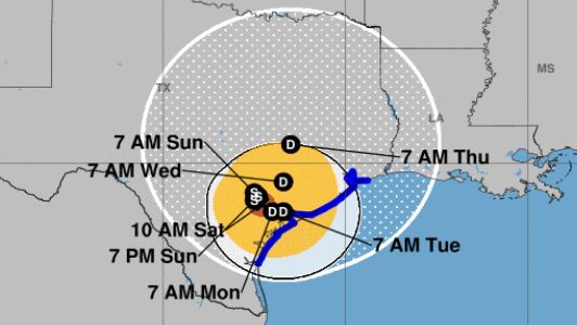
National Weather Service Hurricane Harvey on Saturday, August 26 at 10 a.m.
El Paso is not in the immediate path of Hurricane Harvey, but the city could see scattered thunderstorms producing some areas of rain.
On Saturday, August 26, though, the city wasn’t seeing a lot of it.
Beautiful day today. Mostly sunny this morning, partly cloudy with just a slight chance for rain later today. Wind from the east at 10 to 15
There were some strong wind speeds detected.
Just 16 hours before, there was some flooding.
I-10 West at Porfirio Diaz, Flooding, right three lanes closed, backup to Cotton, clearing time until further notice
The storm became a Category 4 hurricane with 130 mph winds on August 25, and it made landfall at about 8 p.m. near Rockport. It’s now a Category 1 hurricane with 75 mph winds.
According to the El Paso Herald Post, “A hurricane hasn’t hit Texas soil since 2008, and the coastal region’s surging population and booming oil industry — coupled with past weather events — are raising concerns that the state is unprepared.”
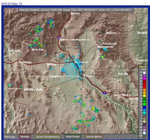
El Paso, Texas radar as of 1 p.m. on Saturday, August 26.
See an up-to-the-minute radar map for El Paso here. Here’s an updated satellite map of the hurricane.
See an hourly weather forecast map for El Paso here.
The National Weather Service’s hazardous weather outlook for El Paso, Texas, said just before noon on August 26:
DAY ONE (Saturday)…This Afternoon and Tonight Isolated lowland and scattered mountain thunderstorms. Several storms may produce up to 2 inches of rain with localized flooding…especially around low water crossings, poor drainage areas and along arroyos and small streams. Winds gusts to 50 mph and small hail may also occur with a few storms.
DAYS TWO THROUGH SEVEN…Sunday through Friday. Generally isolated showers and thunderstorms during the afternoon and evening hours. Brief heavy rains may cause minor flooding over several locations. Otherwise most areas will experience little or no rainfall during this time.
Here’s the detailed weather forecast as of August 26 for El Paso from The National Weather Service:
This Afternoon (Saturday)
“Isolated showers and thunderstorms. Mostly sunny, with a high near 89. East wind around 8 mph. Chance of precipitation is 20%.”
Tonight
“Isolated showers and thunderstorms. Partly cloudy, with a low around 70. East wind 6 to 8 mph. Chance of precipitation is 20%.”
Sunday
“Isolated showers and thunderstorms before 7am. Mostly sunny, with a high near 92. East wind 6 to 10 mph. Chance of precipitation is 10%.”
Sunday Night
“Partly cloudy, with a low around 71. East wind 7 to 10 mph.”
Monday
“Mostly sunny, with a high near 91. East wind 6 to 10 mph.”
Monday Night
“Partly cloudy, with a low around 68. East wind 7 to 10 mph.”
Tuesday
“Sunny, with a high near 88. East wind 6 to 8 mph.”
Tuesday Night
“Mostly clear, with a low around 68. East southeast wind around 8 mph.”
Wednesday
“Sunny, with a high near 90. East wind around 7 mph.”
Wednesday Night
“Mostly clear, with a low around 69.”
Thursday
“Sunny, with a high near 91.”
Thursday Night
“Mostly clear, with a low around 70.”
Friday
“A 20 percent chance of showers and thunderstorms. Sunny, with a high near 92.”