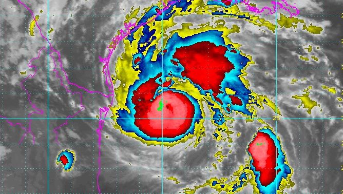
National Weather Service Hurricane Harvey satellite image as of Thursday night.
Mandatory evacuations have not been issued for Houston itself, but some mandatory and voluntary evacuations have been recommended in nearby areas within the Houston-Galveston region.
As of 9:30 p.m. on Thursday, the following evacuations in Texas had been declared.
Mandatory Evacuations:
- In Aransas County: Cities of Aransas Pass and Rockport
- Coastal communities in Brazoria County along the Gulf side of the Intracoastal canal. This includes Surfside, Sargent and Palacios beginning Friday at 8 a.m. This is due to possible storm surges.
- Calhoun County (entire county)
- Matagorda County: all areas south of FM 521 and FM 2611 in Sargent, all areas south of FM 52, and areas south of Business 35 W of Palacios
- Nueces County: City of Port Aransas has mandatory evacuation
- Refugio County
- San Patricio County
Voluntary Evacuations:
- Bee County
- Brazoria County: Low-lying coastal areas inland of the Intracoastal Waterway
- Cameron County: Voluntary evacuation of RVs in county parks, and of the City of South Padre Island
- Chambers County: Smith Point, Cedar Point, recreational vehicles, unanchored mobile homes, low-lying areas known to flood
- Galveston County: Voluntary for residents on the Bolivar Peninsula as of Friday at 8 a.m.
- Harris County: City of Seabrook
- Jackson County
- Kleberg County: Ricardo, Riviera, Loyola Beach/Baffin Bay area
- Nueces County: Corpus Christi evacuation encouraged by not mandatory
- Victoria County
These evacuations can change frequently, so be sure to check your local weather station for the latest updates.
If you’re wanting to get a safe distance from the storm, here’s a map from the Texas Department of Transportation showing possible evacuation routes from the Houston and Galveston regions. See more maps here.

Texas Department of TransportationHouston and Harris County evacuation routes.
Before leaving, check with Google Maps for the latest traffic you’ll encounter. Remember: evacuating often leads to a much longer travel time than normal. So if you’re planning to leave, it’s far better to do so sooner rather than later
Read more about the forecast for Houston in Heavy’s story below: