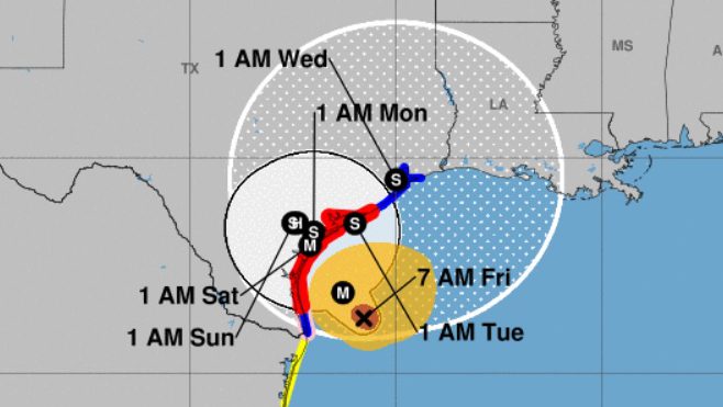
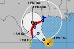
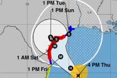
National Hurricane Center Hurricane Harvey on Friday, August 25. The cone contains the probable path of the storm.
Hurricane Harvey made landfall in Rockport, Texas, and people in Galveston are also bracing for the storm and the potential for severe flooding.
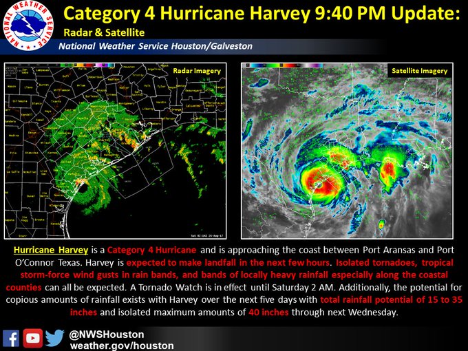
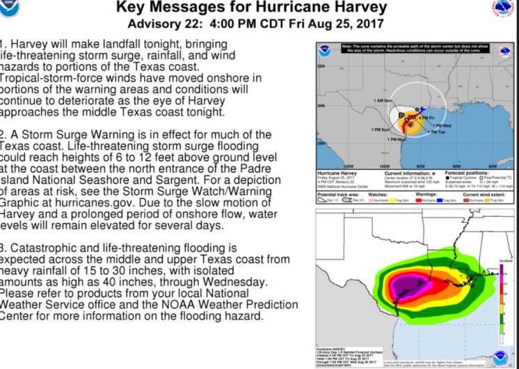
The hurricane is now a Category 4 storm with 130 mph winds.
Eye of Category 4 #Harvey almost onshore in Texas. Hurricane force winds reported at many observing stations. Landfall expected very soon.
“Life threatening storm surge inundation is expected, and a slow drift of the storm could result in catastrophic flooding possible, especially south of the I-10 corridor,” according to The National Weather Service. “Catastrophic flooding” was predicted.
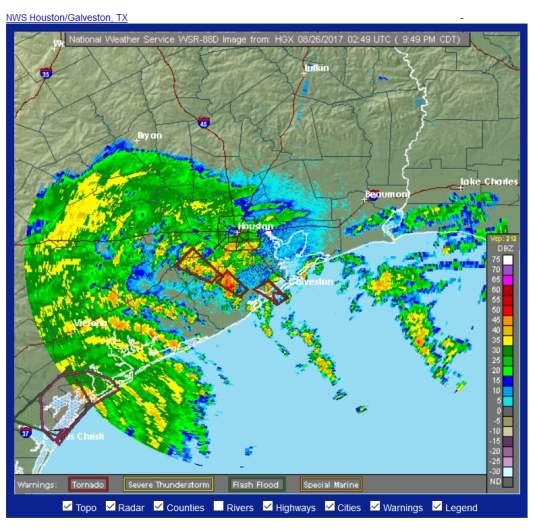
National Weather ServiceHouston/Galveston radar at 10 p.m. on August 25.
“The following watches and warnings are in effect for Southeast Texas: A Hurricane Warning in effect from Port Mansfield to Sargent, TX Tropical Storm Warning in effect from Matagorda to High Island Storm Surge Warning is in effect from Port Mansfield to High Island Storm Surge Watch is in effect around Galveston Bay,” The National Weather Service reported on August 25.
Reported the Houston Chronicle, “The hurricane is supposed to stall near or just inland of the middle Texas coast through the weekend.”
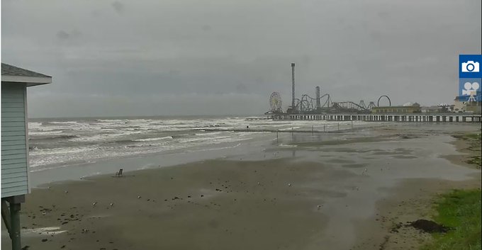
Starting to get choppy on Galveston Beach…. 15 hours til Hurricane Harvey makes landfall

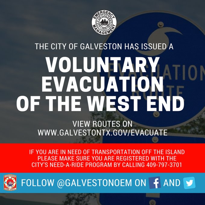
“Concerns about high winds and higher tides have officials in Galveston making preparations ahead of Hurricane Harvey,” reported ABC13. “So far, only voluntary evacuations have been issued for people with medical or access and functional needs on the West End of Galveston. Officials, however, are telling people in low lying areas that they may want to leave.”
Click2Houston reports that Galveston is in a “state of readiness” and under a tropical storm and storm surge that was issued August 23 for the island.
Jaree Fortin, a spokesperson for the city of Galveston, told Click2 Houston that “even though the forecast is still uncertain, they’re expecting high tides in the next 72 hours, which could lead to a lot of flooding.”
According to The Houston Chronicle, Hurricane Harvey is poised to be “the first major hurricane to threaten the coast in more than a decade.”
Watching #HurricaneHarvey coverage on @weatherchannel! Man the waves in Galveston look vicious!!
“The Houston region could be seeing rainfall and feeling the storm’s winds by late Friday morning,” The Chronicle reported.
30-second imagery of rapidly intensifying Hurricane #Harvey from GOES-16.
Here’s what you need to know:
Closings & Evacuations
Galveston.com has an updated list of closings due to Hurricane Harvey.
According to ABC 13, “Several historical sites in Galveston have announced they will be closed from Friday until Sunday, including Bishop’s Palace, the Tall Ship Elissa, and Pier 21 Theater.”
A voluntary evacuation has been ordered for all residents living west of the Seawall. t.co/R0xmByB9Ik for more.
KHOU reported that “in the historic Strand District, where flooding is all too common, crews were busy stacking sandbags Thursday. Residents determined to ride out the storm packed stores to stock up on supplies.”

“Nearby on the Bolivar Peninsula, the Galveston County judge issued a a voluntary evacuation for residents on Bolivar Peninsula effective Friday at 8 a.m,” KHOU reported. “This order includes the unincorporated areas of Port Bolivar, Crystal Beach, High Island and Gilchrist. Residents who rely on medical assistance or those who cannot go without power for an extended period of time are encouraged to leave.”
Read the Houston/Galveston hurricane and severe weather guide from the National Weather Service here:
According to the television station, “The Bolivar Ferry was still running Thursday but that could Chetek Tornado | Barron Countychange if tides reach more than 4.5 feet or winds reach more than 45 mph.”
Category, Warnings, & Windspeeds
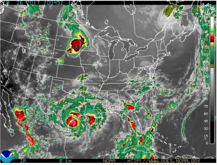
National Weather ServiceNational Weather Service radar as of 9 p.m. on August 25, 2017.
This National Weather Service page has a detailed hourly forecast for Houston/Galveston that includes windspeeds and many other data points.
You can check current weather warnings for the Houston/Galveston area here.
Galveston.com also has an updated blog with current weather forecasts for Galveston, Texas.
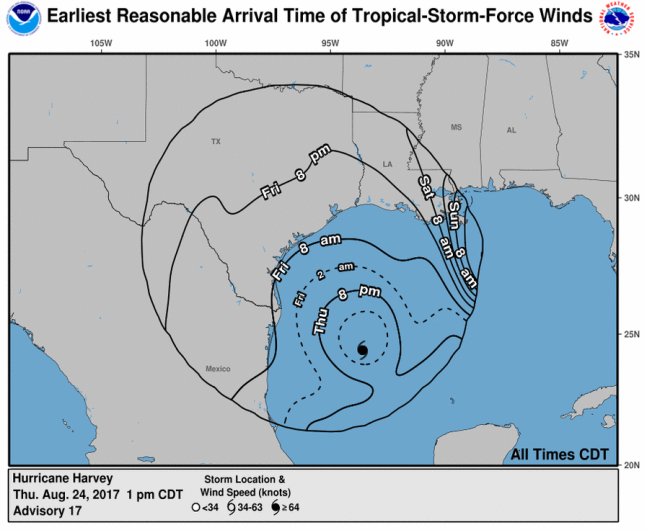
Hurricane Harvey projected wind arrival times.
The National Hurricane Center reports that hurricane force winds are described as “one-minute average wind speeds of at least 74 mph” and tropical storm force winds are “one-minute average wind speeds of 39-73 mph.”
Path & Radar
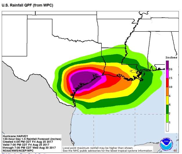
The National Weather Service reports that the Houston/Galveston area’s primary impact from Harvey “remains very heavy rainfall and extreme flooding for southeast Texas. There is also the threat for tropical storm to hurricane force winds and storm surge along the coast. The most likely arrival time for tropical storm force winds to reach the upper Texas coast is during the day on Friday. Since the wind fields have expanded in Harvey, higher storm surge can be expected up the Texas coast. Again, we want to emphasize the high amounts of rainfall that could lead to widespread and prolonged.”
According to the Houston Chronicle, the storm’s path is “is similar to that of Tropical Storm Allison,” which, in Harris County, “left 22 dead and 30,000 homeless, and caused more than $5 billion in property damages.”
You can see updated Houston/Galveston radar reports here.
This page by the National Hurricane Center has a current map that tracks Hurricane Harvey’s path through Texas.
Will Hurricane Harvey hit Houston too? The Dallas Morning News reports that’s expected to be one of the hardest hit areas. “People are being advised to reconsider any weekend travel plans they have to the coast, and surrounding areas like Houston, where Harvey is expected to hit the hardest,” the newspaper reported. “Those living in the affected areas are encouraged to secure themselves and their belongings by Thursday night” August 24.
Forecast & Rainfall
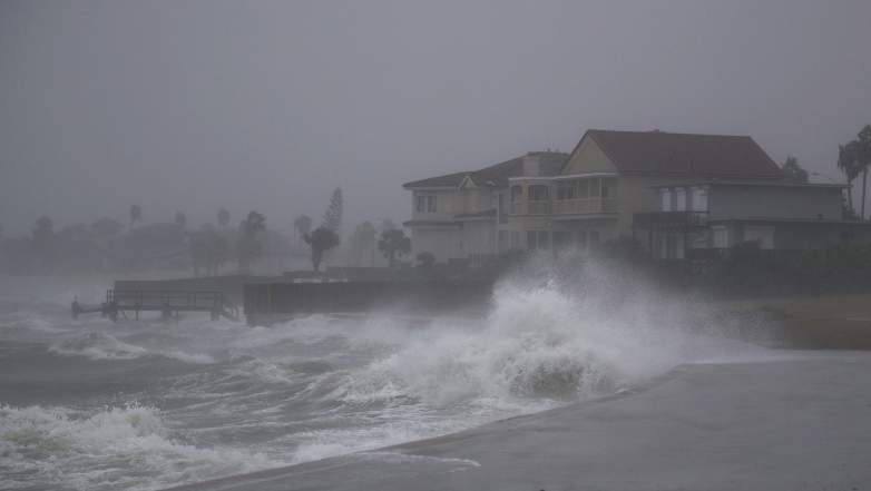
GettyWaves pound the shore from approaching Hurricane Harvey on Friday in Corpus Christi, Texas.
You can see another updated weather forecast for Galveston here on the National Hurricane Center’s website.
See a current graphical forecast map here.
The forecast for Friday in Galveston from the National Weather Service: “Showers and thunderstorms. Some of the storms could produce gusty winds and heavy rain. High near 84. Windy, with an east wind 20 to 25 mph, with gusts as high as 35 mph. Chance of precipitation is 80%. New rainfall amounts between 1 and 2 inches possible.”
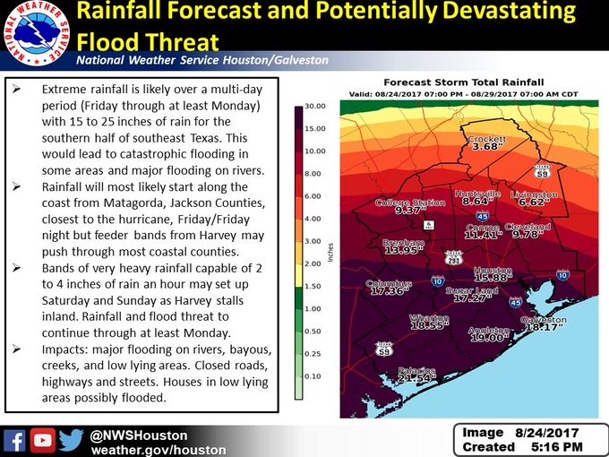
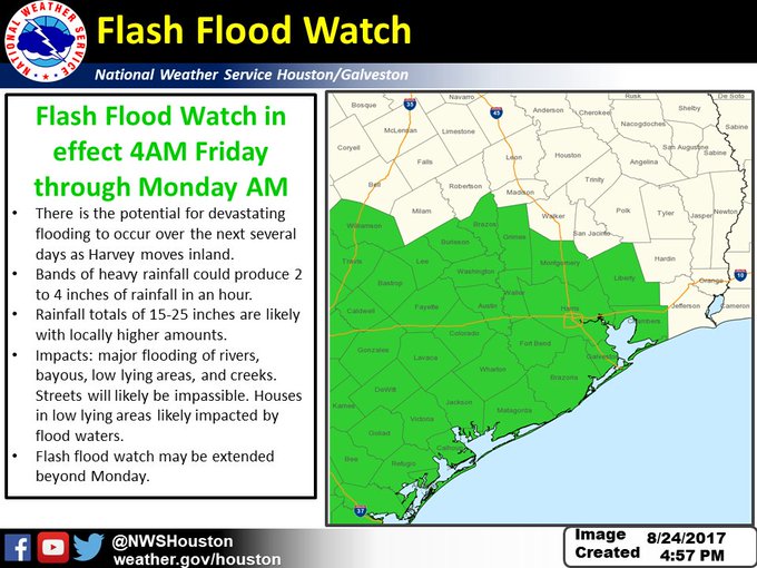
Updated #FlashFloodWatch info for #Harvey: life threatening rainfall and flooding expected Friday night through Tuesday #houwx #glswx #txwx
Friday Night: “Tropical storm conditions expected. Showers and thunderstorms. Some of the storms could produce gusty winds and heavy rain. Low around 78. Chance of precipitation is 80%. New rainfall amounts between 1 and 2 inches possible.”
Saturday: “Tropical storm conditions expected. Showers and thunderstorms. Some of the storms could produce gusty winds and heavy rain. High near 83. Chance of precipitation is 80%.”
Saturday Night: “Tropical storm conditions possible. Showers and thunderstorms. Some of the storms could produce gusty winds and heavy rain. Steady temperature around 83. Chance of precipitation is 80%.”
Sunday: “Tropical storm conditions possible. Showers and thunderstorms. Some of the storms could produce heavy rain. High near 83. Chance of precipitation is 80%.”
Sunday Night: “Tropical storm conditions possible. Showers and thunderstorms likely. Some of the storms could produce heavy rain. Cloudy, with a low around 76. Chance of precipitation is 70%.”
According to ABC 13, on August 24, “A Hurricane Warning has been issued for the Texas coast from Port Mansfield to Matagorda. A Tropical Storm Warning has been issued from north of Matagorda to High Island Texas. A Storm Surge Warning is in effect for Port Mansfield to San Luis Pass.”