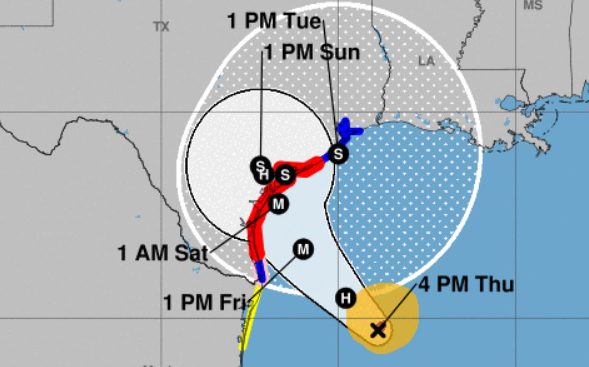
hurricane harvey The cone shows the probable path of Hurricane Harvey's center.
Hurricane Harvey is expected to make landfall in Corpus Christi Texas, but people in Houston are also bracing for the storm.
According to The Houston Chronicle, Hurricane Harvey is poised to be “the first major hurricane to threaten the coast in more than a decade.”
(Update 1: You can see our August 25 summary for Houston here.)
#Harvey strengthening rapidly … and crawling. Slow-moving means Houston sees flooding! 20″-30″+ rain possible.

“The Houston region could be seeing rainfall and feeling the storm’s winds by late Friday morning,” The Chronicle reported, adding that Harris County is under a “storm surge watch.” A tropical storm warning is in effect for Harris County. You can read storm surge details for Houston here. It read: “Storm Surge Watch issued August 24 at 4:26PM CDT by NWS Houston/Galveston TX. LATEST LOCAL FORECAST: Below tropical storm force wind. Peak Wind Forecast: 25-35 mph with gusts to 45 mph.”
The City of Houston reports that it “is monitoring Hurricane Harvey in the Gulf of Mexico. Houston residents can expect to see a significant amount of rainfall over the next five days, which will likely lead to flooding. It is important that Houston residents stay aware, and begin taking steps in the event Hurricane conditions affect our area in the next few days.”
30-second imagery of rapidly intensifying Hurricane #Harvey from GOES-16.
“Flooding is the main threat to the Greater Houston Area,” KHOU-TV reports, not wind, at least at this point.
Passing Houston on way to Texas Gulf Coast to cover Hurricane Harvey.

Here’s what you need to know:
School Closings & Evacuations
BREAKING: Harvey is classified as a hurricane with 80 mph winds, could make landfall as Category 3 storm. t.co/vaDUz3KoSg
See a list of Houston closings and delays here.
The City of Houston is providing updated information about the storm on its social media sites. The city provides a map for hurricane evacuation zones if it comes to that. The city reported on August 24, “Evacuations for this storm system in the City of Houston are unlikely, but may be possible for coastal areas. It’s always a good practice to know whether or not you live in an evacuation zone.”
There are NO evacuations in place in the City of @HoustonTX. None expected at this time.📲 t.co/pQ39qgYxEL #Harvey
You could register for the city’s emergency alert system to receive updated information on the hurricane.
First pass through the eye of #HurricaneHarvey in WP-3D Orion #NOAA42
Credit: LT Kevin Doremus/NOAA
The Houston Independent School District has postponed the start of the new school year thanks to Hurricane Harvey. Students in the district were scheduled to start on Monday, August 28, but the state’s largest school district will instead start school on Tuesday, August 29.
Schools in Houston will be closed Monday because of the threat posed by Hurricane Harvey, officials say t.co/ZRRt8zickb

The district wrote in a news release, “All HISD campuses and administrative offices will be closed on Monday, Aug. 28 and all campus and district activities canceled due to the threat of inclement weather. Classes are scheduled to resume on Tuesday, Aug. 29. However, the district will continue to monitor developing weather conditions and will determine whether classes can safely resume on Tuesday. The district will make that decision by noon on Sunday, Aug. 27.”
Read the Houston/Galveston hurricane and severe weather guide from the National Weather Service here:
Read about how Hurricane Harvey was named here:
Category, Warnings, & Windspeeds
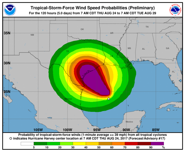
National Hurricane Center wind speed map for Hurricane Harvey.
The city of Houston urges people to check out this forecast.
This National Weather Service has a detailed hourly forecast for Houston that includes windspeeds and many other data points.
Houston is under a tropical storm warning during #Harvey. @HoustonOEM @ReadyHarris @AlertHouston will all be great places for updates.
You can check current weather warnings for the Houston area here.
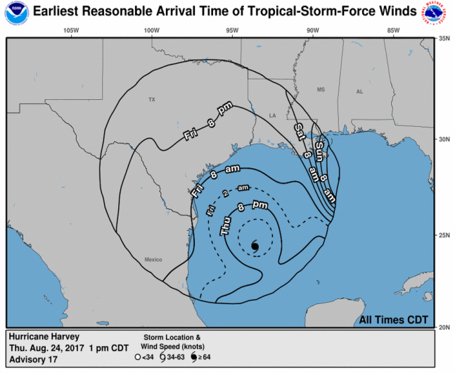
Hurricane Harvey projected wind arrival times.
According to CNN, Hurricane Harvey “is forecast to become a Category 3 hurricane with winds of at least 111 mph by the time it hits the middle Texas coast late Friday or early Saturday…After hitting Corpus Christi, the storm is expected to stall over the state, forecasters say.”
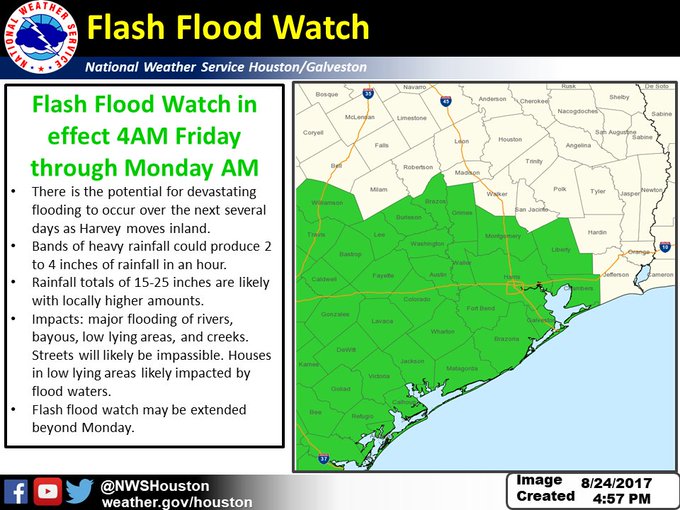
Updated #FlashFloodWatch info for #Harvey: life threatening rainfall and flooding expected Friday night through Tuesday #houwx #glswx #txwx
The National Hurricane Center reports that hurricane force winds are described as “one-minute average wind speeds of at least 74 mph” and tropical storm force winds are “one-minute average wind speeds of 39-73 mph.”
Path & Radar
#Harvey is now predicted to become the first category 3 hurricane to make landfall in the US since Wilma in 2005.

According to the Houston Chronicle, the storm’s path is “is similar to that of Tropical Storm Allison,” which, in Harris County, “left 22 dead and 30,000 homeless, and caused more than $5 billion in property damages.”
You can see updated Houston radar reports here.
This page by the National Hurricane Center has a current map that tracks Hurricane Harvey’s path through Texas.
Will Hurricane Harvey hit Houston? The Dallas Morning News reports that’s expected to be one of the hardest hit areas. “People are being advised to reconsider any weekend travel plans they have to the coast, and surrounding areas like Houston, where Harvey is expected to hit the hardest,” the newspaper reported. “Those living in the affected areas are encouraged to secure themselves and their belongings by Thursday night” August 24.
At 1 p.m. on August 24, “Harvey was a Category 1 hurricane with 85 mph winds. It was about 335 miles southeast of Corpus Christi, and was moving north-northwest at 10 mph,” CNN reported.
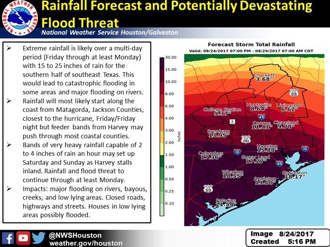
Forecast & Rainfall
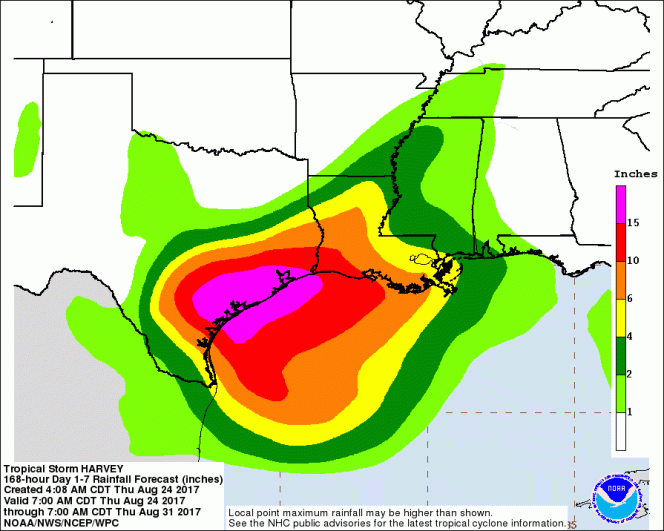
Hurricane Harvey rainfall projections.
There is potential in Houston for a lot of rain. “The storm’s sluggish pace increases the odds that Harris County – and areas across southeast Texas – could see levels of rainfall comparable to Tropical Storm Allison or the 2016 Tax Day Floods, but even more widespread,” Houston Chronicle quoted Jeff Lindner, a meteorologist with the Harris County Flood Control District, as saying.
“The potential here is for big rain amounts over a very large area,” Lindner said to the newspaper. “That’s something that’s somewhat unprecedented across the Texas coast.”
According to KHOU, “Houston is forecast to receive 5″ to 15″ of rain with flooding possible this weekend into early next week. KHOU 11 Chief Meteorologist David Paul warns some isolated parts of Houston could receive up to 30″ of rain, which means we will need to keep a close eye on our bayous.”
You can see the updated weather forecast for Houston here on the National Hurricane Center’s website. The center reports that “tropical storm conditions” are possible for Houston starting on Friday, August 24.
See a current graphical forecast map here.
The forecast for Friday reads: “Tropical storm conditions possible. Showers and thunderstorms likely. Some of the storms could produce heavy rain. Cloudy, with a high near 88. Chance of precipitation is 60%. New rainfall amounts between a half and three quarters of an inch possible.”
The forecast for Saturday reads: “Tropical storm conditions possible. Showers and thunderstorms. Some of the storms could produce heavy rain. High near 84. Chance of precipitation is 80%.”
The forecast for Sunday, August 27 reads: “Tropical storm conditions possible. Showers and thunderstorms likely. Some of the storms could produce heavy rain. Cloudy, with a high near 83. Chance of precipitation is 70%.”
According to ABC 13, on August 24, “A Hurricane Warning has been issued for the Texas coast from Port Mansfield to Matagorda. A Tropical Storm Warning has been issued from north of Matagorda to High Island Texas. A Storm Surge Warning is in effect for Port Mansfield to San Luis Pass.”