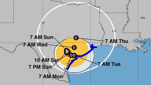
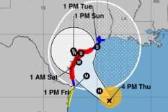
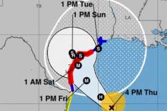
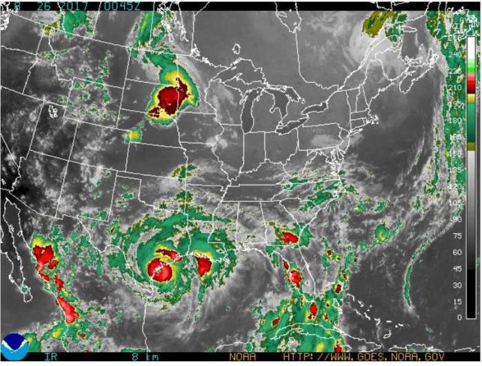
National Weather Service Hurricane Harvey on Saturday, August 26 at 10 a.m.
Hurricane Harvey was a Category 4 with 130 mph winds when it made landfall in Rockport, Texas, and, although it’s dissipated to a Category 1, people in San Antonio should brace for the possibility of flash floods and strong winds.
The National Weather Service warning for San Antonio on August 26 read, “Hurricane Harvey will meander over southeastern Texas through the middle of next week. This slow movement will produce as much as 3 feet of rainfall in places. This will produce devastating flooding. Winds are continuing to decrease and Harvey is likely to become a tropical storm later today. However, rainfall is the primary threat from Harvey. Remember, ‘Turn Around, Don’t Drown.”
11:45a – Here are recent wind observations from around Central Texas. Gusts from 40-50mph in many places.

The hurricane made landfall in Rockport on August 25, damaging buildings and injuring at least 10 people. By Saturday, August 26, it was a Category 1 storm with 75 mph winds, but there are concerns about tornadoes as well as flooding. It was traveling north at 2 mph, according to CNN on August 26.
10:32a – Brief break for Austin/San Antonio before the rains closer to the center of Harvey approach.
Heavy rains were the big concern in San Antonio; showers were moving into the coastal plains.
As of 10:45a – Updated Rainfall totals: 0.54 (San Antonio), 1.79 (Austin Mabry), 1.97 (New Braunfels)
The National Weather Service is providing other updated information. You can see up-to-the-minute tracking maps here. See the latest forecasts and radar later in this story.
11:07a – New Braunfels Airport just saw a 50 knot wind gust…that is 57.5 mph. That is Tropical Storm Force Winds!
What’s the effect on San Antonio? The National Weather Service reported that a flash flood watch was in effect from Friday afternoon through Monday morning for San Antonio. The flash flood watch was for “a portion of south central Texas, including the following areas, Atascosa, Bastrop, Bexar, Caldwell, Comal, De Witt, Fayette, Gonzales, Guadalupe, Hays, Karnes, Lavaca, Lee, Travis, Williamson, and Wilson” and starts at 1 p.m. August 25.
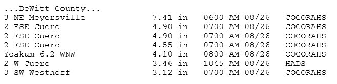
11:06a – Highest RAINFALL totals in the last 24 hours. Parts of Bastrop, Caldwell, DeWitt, Fayette Co seen 4-7 in. t.co/4nyzIhIdvp
According to MySanAntonio.com, the “massive, slow-moving storm…could pack 60 mph winds and dump up to a foot of rain on parts of the Alamo City over the next several days.”
#Tropical storm force winds nearing the TX coast. Continuously updated #Harvey forecast: t.co/ba50CtWVxC

According to San Antonio.gov, “The City of San Antonio’s Office of Emergency Management (OEM) has activated the Emergency Operations Center in preparation for rain and inclement weather conditions that may be caused by Hurricane Harvey.” You can see a list of current Texas weather warnings and watches here.
The city added, “The residents of San Antonio and Bexar County are encouraged to prepare their households for heavy rain and flooding by having enough water and food for at least three days, any necessary medications and an evacuation plan.”
According to Fox News, the hurricane was the most powerful to “threaten the U.S. in 12 years.”
“Residents should be prepared for heavy rain & flooding from Hurricane Harvey…STAY home; STOCK up on food, water & medications; & STAY SAFE!” the City of San Antonio wrote on its official Facebook page.
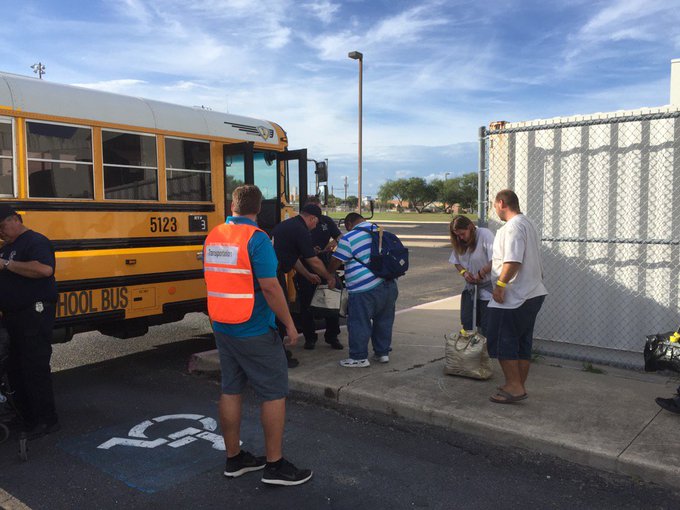
People boarding buses and evacuating to San Antonio because of Hurricane Harvey. @KRIS6News
According to The Houston Chronicle, Hurricane Harvey is poised to be “the first major hurricane to threaten the coast in more than a decade.”
Here’s what you need to know:
Closings, Evacuations, Volunteer Efforts
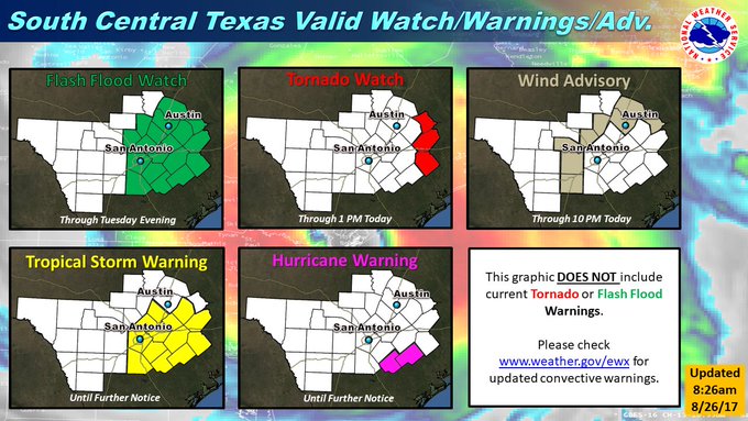
8:44a – Here is an updated graphic of current Watches/Warnings/Advisories. These do not including any convective warnings.
You can see a map of current road closings and flooding in San Antonio here.
KSAT-TV has published a list of San Antonio school and other closings and delays due to Hurricane Harvey. KENS5 also has another full and updated list of closings for San Antonio here.
“Copious amounts of rain are expected beginning Friday Afternoon and lasting through at least Monday morning as Tropical Storm Harvey moves onshore. This watch may need to be expanded in time and area over the next several days as Harvey lingers around the area through the weekend into early Monday. Rainfall totals in the watch area through early next week will average 10 to 20 inches along and east of Interstate 35 with isolated amounts in excess of 25 inches possible along and south of Interstate 10,” the National Weather reports for San Antonio.
“Significant flash flooding is possible as Harvey slowly moves or even stalls. Devastating mainstem river flooding is possible east of Interstate 35 and south of Interstate 10.”
The city provided these other information sites:
Residents can sign up to receive text messages from the City of San Antonio by texting COSAGOV to 55000.
Residents should be prepared for heavy rain & flooding from #HurricaneHarvey. Check back 4 more information or visit t.co/azZwLYpKmc
The city’s Facebook page is also providing updates.
The city has provided information about volunteerism that is needed. “San Antonio Food Bank is accepting donations such as money, food, unused clothing, diapers & other supplies. Please DO NOT bring donated supplies directly to emergency shelters,” the city wrote. You can learn more information about that here.
The city also says that American Red Cross Serving Greater San Antonio needs volunteers to help those affected by Hurricane Harvey. Dial 3-1-1 to help.
Category, Warnings, & Windspeeds
8:15a – The highest winds are going to be limited to the Coastal Plains, but gusty winds will continue today especially in the rain bands

The hazardous weather update for August 26 for San Antonio from the National Weather Service reads as follows:
Hurricane Harvey will continue to slowly move into southeastern portions of South Central Texas later this morning where it is currently predicted to stall. Harvey will continue to weaken over land and fall below hurricane force later today as it moves into DeWitt County. However, widespread heavy rainfall capable of producing river and flash flooding will occur well to the north and east of Harvey. This is just the beginning of a life-threatening and catastrophic heavy rainfall event expected east of
I-35 and I-37 that may continue into the middle of next week.A Hurricane Warning is in effect for 70 to 80 mph winds across Karnes and Dewitt Counties. A Tropical Storm Warning is in effect for winds of 35 to 50 mph across Atascosa, Bastrop, Bexar, Caldwell, Fayette, Gonzales, Guadalupe, Lavaca, and Wilson Counties. A Wind Advisory is in effect for Bandera, Blanco, Frio, Kendall, Lee, Medina, Travis, and Williamson Counties for winds of 25 to 35 mph with gusts to 40 mph in the stronger rainbands.
A Flash Flood Watch is in effect through Tuesday evening for counties along and east of a line from Georgetown to Comfort to Jourdanton.
There is a low risk of brief tornadoes east of I-35 and I-37 today. A Tornado Watch is currently in effect for Fayette, Lavaca, and Lee Counties until 1 pm Saturday.
According to the National Weather Service, 20+ inches of rain is “possible across Southeast portions of South Central Texas. Flash Flooding likely this weekend.”
8:12a – Rainfall and Flooding remain the main threat from Harvey. LCRA gauges are already showing near 5 inches in Fayette County.

“Hurricane Harvey continues to strengthen and will continue to move to the Northwest towards the Texas Coast. Tropical Storm and Hurricane Warnings are now in effect. The storm should impact South Central Texas Friday into the Weekend,” the National Weather Service reports.
This National Weather Service page has a detailed hourly forecast for San Antonio that includes windspeeds and many other data points.
You can check current weather warnings for the San Antonio area here.
The National Hurricane Center reports that hurricane force winds are described as “one-minute average wind speeds of at least 74 mph” and tropical storm force winds are “one-minute average wind speeds of 39-73 mph.”
Path & Radar
The latest radar for San Antonio at 9 p.m. on August 25.
According to the Houston Chronicle, the storm’s path is “is similar to that of Tropical Storm Allison,” which, in Harris County, “left 22 dead and 30,000 homeless, and caused more than $5 billion in property damages.”
You can see updated San Antonio radar reports here and here.
This page by the National Hurricane Center has a current map that tracks Hurricane Harvey’s path through Texas.
National Weather Service radar as of 9 p.m. on August 25, 2017.
Will Hurricane Harvey hit Houston too? The Dallas Morning News reports that’s expected to be one of the hardest hit areas. “People are being advised to reconsider any weekend travel plans they have to the coast, and surrounding areas like Houston, where Harvey is expected to hit the hardest,” the newspaper reported. “Those living in the affected areas are encouraged to secure themselves and their belongings by Thursday night” August 24.
Forecast, Radar & Rainfall
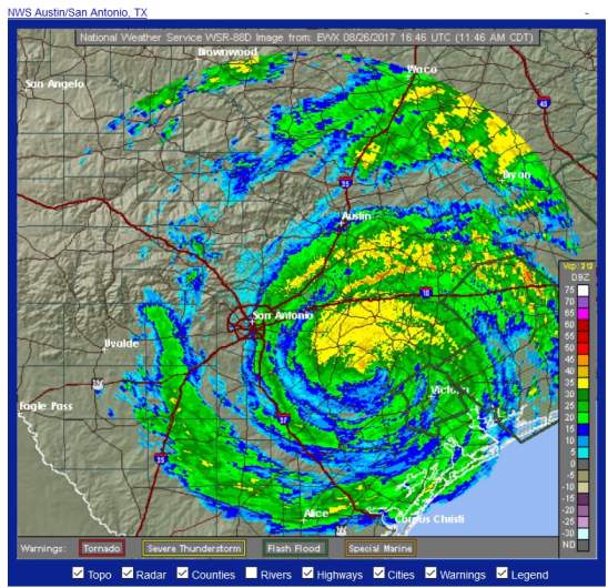
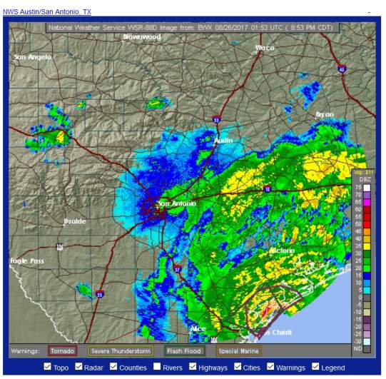
San Antonio radar as of 11:50 a.m. on Saturday, August 26.
See an updated radar map for San Antonio here.
You can see another updated weather forecast for San Antonio here on the National Hurricane Center’s website.
See a current graphical forecast map here.
The San Antonio forecast for Saturday, August 26, according to the weather service: “Tropical storm conditions expected, with hurricane conditions possible. Showers and thunderstorms. Some of the storms could produce heavy rainfall. High near 85. Chance of precipitation is 80%.”
Saturday Night: “Hurricane conditions possible. Showers and thunderstorms. Some of the storms could produce heavy rainfall. Low around 74. Chance of precipitation is 80%.”
Sunday: “Tropical storm conditions possible. Showers and thunderstorms likely. Some of the storms could produce heavy rainfall. Cloudy, with a high near 82. Chance of precipitation is 70%.”
Sunday Night: “Tropical storm conditions possible. Showers and thunderstorms likely. Some of the storms could produce heavy rainfall. Cloudy, with a low around 73. Chance of precipitation is 60%.”
According to ABC 13, on August 24, “A Hurricane Warning has been issued for the Texas coast from Port Mansfield to Matagorda. A Tropical Storm Warning has been issued from north of Matagorda to High Island Texas. A Storm Surge Warning is in effect for Port Mansfield to San Luis Pass.”