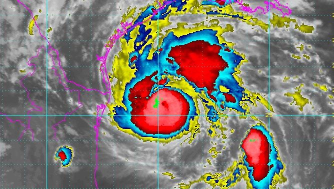
National Weather Service Hurricane Harvey satellite image as of Thursday night.
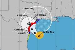
Weather forecasters were estimating that Hurricane Harvey would make landfall on the Texas coast sometime around 1 a.m. on Saturday, based on its current track as of 1 a.m. Central Friday. However, because hurricanes’ paths can be a bit unpredictable, this definitely isn’t an absolute time. Harvey is currently a Category 2, but expected by many to strengthen to a 3 before making landfall.
Long before the hurricane arrives, Texas will be feeling tropical storm strength winds.
The coast will start feeling tropical storm winds around 2 p.m. on Friday, according to National Hurricane Center. By Saturday morning, tropical storm winds will be felt closer to central Texas.
Hurricane Harvey is a Category 2 as of 1 a.m. on Friday, but is expected by many forecasters to strengthen to a Category 3 before it makes landfall.
The hurricane is currently expected to make landfall about 250 miles southeast of Corpus Christi. Of course, any slight deviation could change the hurricane’s course. Hurricanes are a bit difficult to predict with exactly clarity at this stage.
Forecasters are worried that Harvey might stall for two to three days over southeastern Texas. This could lead to serious flooding issues in those regions. Some isolated places may receive up to 35 inches of rain, CNN warned.
If Harvey is a Category 3 storm when it makes landfall, it will be the first major hurricane (Category 3 or higher) to make landfall on the U.S. coast since Wilma in 2005.
Residents of Corpus Christi are being urged to evacuate, especially in low-lying areas, but there was no mandatory evacuation in place as of 1 a.m. on Friday. In Corpus, the low-lying regions include ZIP codes 78418 and 78373 (both on the Island), and 78402, 78418 (Flour Bluff) and 78419. Here’s a message from the City of Corpus Christi’s official Twitter page explaining this in more detail:
Mayor McComb strongly encourages evacuation, especially the low lying areas of Area A and B as seen in the map below (pink and yellow area).