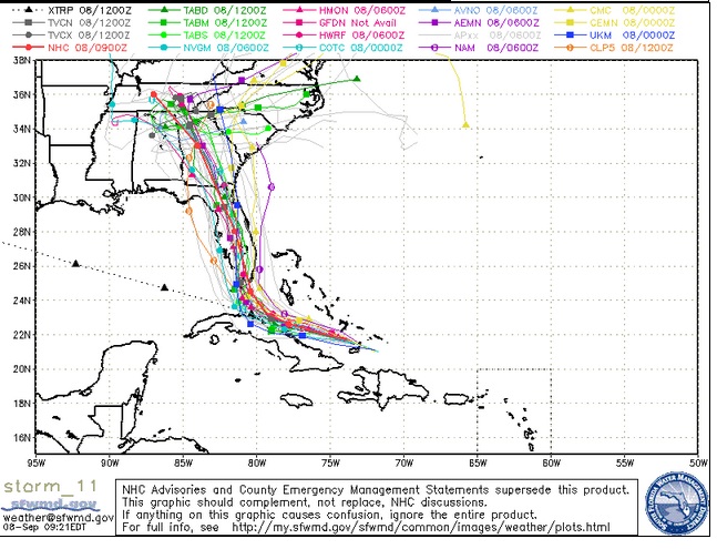
South Florida Waste Management District Spaghetti model for September 8.
Forecasting models for September 8 increasingly show that the State of Georgia – and possibly also Atlanta – could feel the effects of Hurricane Irma.
“The track of Hurricane Irma now has metro Atlanta taking a direct hit from the storm,” noted WSB-TV. However, it’s not at all clear how strong the storm would still be if it got there, and the models and storm remain unpredictable and could change. Furthermore, the extended weather forecast for Atlanta did not predict hurricane conditions on September 8.
Here’s the 11 a.m. update:


However, the latest models on Friday showed that, after tacking east, the hurricane now appears to be shifting west and making a beeline for southern Florida and, after that, Georgia and Tennessee. South Carolina was more in peril in the September 7 maps than it was in the September 8 maps. The governor took notice of the westward trend. See updated radar for Atlanta here.
“Updated projections of Hurricane Irma show the massive storm could track further west than originally anticipated as it moves through Georgia on Monday, Gov. Nathan Deal said Friday,” according to the Atlanta Business Chronicle. WSB-TV reports that the effects on Atlanta would not likely be seen until late Monday night or Tuesday morning.
WSB-TV metereologist Katie Walls said those impacts, while unknown, could include 3-6 inches of rain, minor flooding, 40-70 mph winds, and possibly tornadoes.
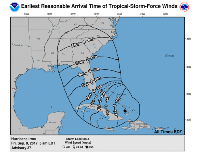
Let’s look at a few of the models. The National Hurricane Center’s forecast cone now has all of Georgia inside of it:
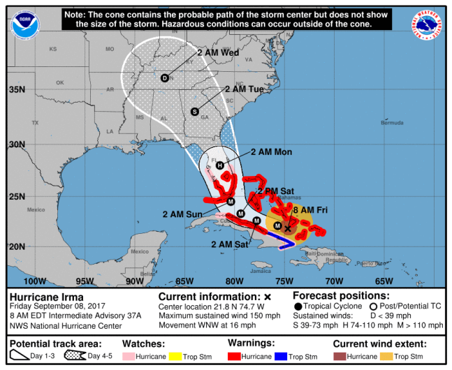
GettyNOAA’s Hurricane Irma forecast as of 8 a.m. ET.
To see the progression, here’s the cone for September 6:
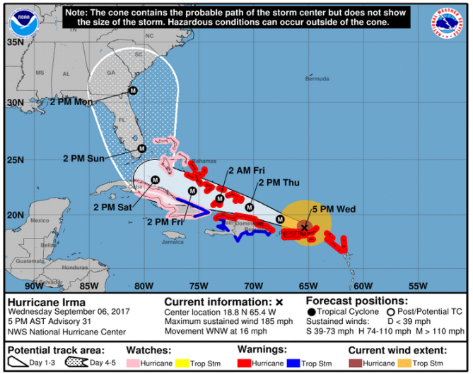
National Weather ServiceThe Hurricane Irma forecast cone as of 5 p.m. on September 6.
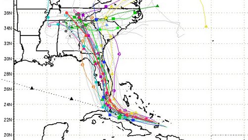
Recent spaghetti models on September 8 also impart bad news for Georgia – potentially.
South Florida Waste Management DistrictFriday morning September 8 spaghetti model.
Here’s another model:
National Hurricane Center
And:
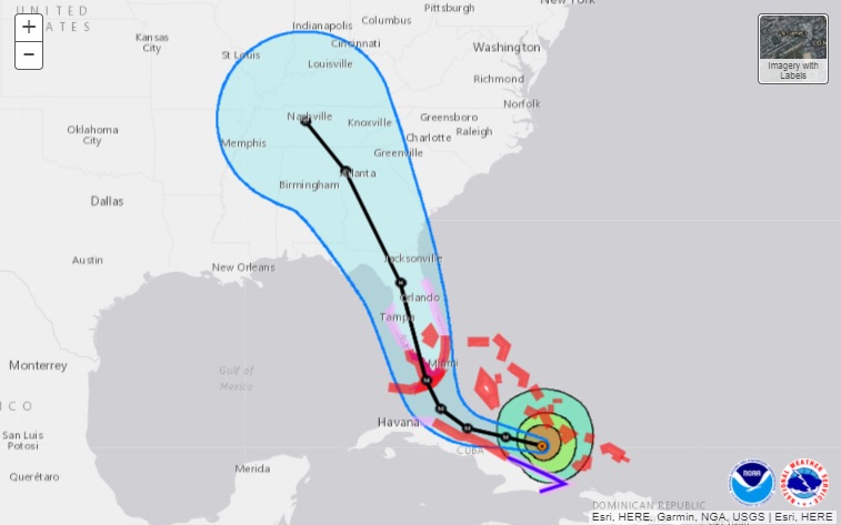
NOAAThe latest track of Hurricane Irma shows it heading up through Florida’s spine an impacting more people than first originally thought.
Here’s the September 8 extended forecast for Atlanta:
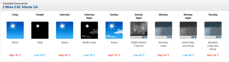
September 8 extended forecast for Atlanta Georgia.
The extended forecast for Atlanta, Georgia read as follows on September 8:
“Today (September 8)
Sunny, with a high near 80. East wind around 5 mph.
Tonight
Clear, with a low around 59. Northeast wind around 5 mph.
Saturday
Sunny, with a high near 80. Northeast wind 5 to 15 mph, with gusts as high as 20 mph.
Saturday Night
Mostly clear, with a low around 59. Northeast wind 10 to 15 mph, with gusts as high as 20 mph.
Sunday
Sunny, with a high near 76. Northeast wind 10 to 15 mph, with gusts as high as 25 mph.
Sunday Night
A 20 percent chance of showers and thunderstorms. Partly cloudy, with a low around 60.
Monday
Showers likely and possibly a thunderstorm. Mostly cloudy, with a high near 69. Chance of precipitation is 70%.
Monday Night
Showers and possibly a thunderstorm. Some of the storms could produce heavy rainfall. Low around 60. Windy. Chance of precipitation is 80%.
Tuesday
Showers likely and possibly a thunderstorm. Cloudy, with a high near 68. Windy. Chance of precipitation is 60%.
Tuesday Night
A 30 percent chance of showers and thunderstorms. Mostly cloudy, with a low around 58.
Wednesday
A 20 percent chance of showers and thunderstorms. Partly sunny, with a high near 77.
Wednesday Night
A 20 percent chance of showers and thunderstorms. Partly cloudy, with a low around 61.
Thursday
A 20 percent chance of showers and thunderstorms. Mostly sunny, with a high near 80.”