National Hurricane Center
With Hurricane Irma looming over Florida, many areas of the state are already under hurricane warnings and watches.
Which communities had hurricane watches and warnings as of Saturday, September 9?
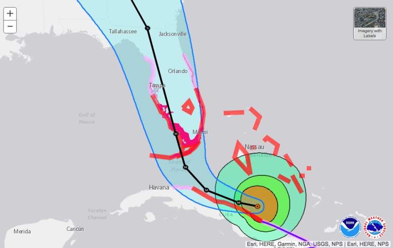
The National Hurricane Center codes areas with hurricane watches and warnings in its cone forecast updates. Here’s the update for 11 p.m. September 8 (you can see the September 9 list of cities and counties under hurricane watches and warnings below). The hurricane warnings are in red. The hurricane watches are shaded pink.
The Irma forecast at 11 p.m. on September 8.
The National Weather Service also has a page that allows you to look up weather and watches by state. There were a lot of warnings and watches listed for The State of Florida in the early morning hours of September 9. Here are all of the hurricane watches and warnings for Florida, including storm surge and flood warnings and watches. The information is updated every two-three minutes.
Here’s the list as September 9 arrived (Note that the list is very time sensitive. You can click on the link above to see almost real-time information):
Hurricane warnings
Glades
Hendry
Inland Palm Beach County
Metro Palm Beach County
Coastal Collier County
Inland Collier County
Inland Broward County
Metro Broward County
Inland Miami-Dade County
Metropolitan Miami-Dade
Mainland Monroe
Coastal Palm Beach County
Coastal Broward County
Monroe Upper Keys
Monroe Middle Keys
Monroe Lower Keys
Coastal Miami Dade County
Far South Miami-Dade County
Hardee
Highlands
DeSoto
Coastal Manatee
Coastal Sarasota
Coastal Charlotte
Coastal Lee
Inland Manatee
Inland Sarasota, Inland Charlotte
Inland Lee
Indian River
Okeechobee
St. Lucie
Martin
Hurricane watches
Sumter
Inland Volusia County
Northern Lake County
Orange
Seminole
Southern Brevard County
Osceola
Coastal Volusia County
Southern Lake County
Northern Brevard County
Pinellas
Polk
Coastal Levy
Coastal Citrus
Coastal Hernando
Coastal Pasco
Coastal Hillsborough
Inland Levy
Inland Citrus
Inland Hernando
Inland Pasco
Inland Hillsborough
Hamilton
Suwannee
Columbia
Baker
Inlaand Nassau
Insland Duval
Union
Bradford
Putnam
Flagler
Marion
Coastal Nassau
Coastal Duval
Clay
St. Johns
Gilchrist
Alachua
Inland Franklin
Leon
Inland Jefferson
Madison
Inland Wakulla
Inland Taylor
Lafayette
Inland Dixie
Coastal Franklin
Coastal Jefferson
Coastal Wakulla
Coastal Taylor
Coastal Dixie
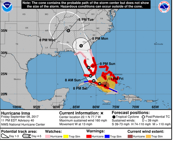
The National Weather Service noted on the evening of September 8: “Powerful Category 5 Hurricane Irma continues to move west northwest near the northern coast of Cuba. The latest forecast track takes Irma northward over the far western part of the Florida Peninsula. Irma is a large hurricane and will produce far-reaching effects regardless of where the exact center of the storm moves. The primary concerns given the current forecast track would be excessive rainfall leading to flash flooding, and the potential for tornadoes. …Irma would still generate at least tropical storm force winds, and possibly hurricane-force winds across northeast Florida.”
The notice continued, “Irma is moving toward the west near 12 mph as of this afternoon although a turn toward the northwest is expected by late Saturday. On the forecast track, the eye of Irma should move near the north coast of Cuba and the central Bahamas today and Saturday, and be near the Florida Keys and the southern Florida Peninsula Sunday morning. The hurricane is currently forecast to move up the center of the Florida peninsula Sunday afternoon and into Monday morning.”
The National Weather Service provides these definitions:
Hurricane Watch
“A Hurricane Watch is issued when a tropical cyclone containing winds of 64 kt (74 mph) or higher poses a possible threat, generally within 48 hours. These winds may be accompanied by storm surge, coastal flooding, and/or river flooding.
The watch does not mean that hurricane conditions will occur. It only means that these conditions are possible.”
Hurricane Warning
“A Hurricane Warning is issued when sustained winds of 64 kt (74 mph) or higher associated with a tropical cyclone are expected in 36 hours or less. These winds may be accompanied by storm surge, coastal flooding, and/or river flooding. A hurricane warning can remain in effect when dangerously high water or a combination of dangerously high water and exceptionally high waves continue, even though winds may be less than hurricane force.”