National Hurricane Center
Hurricane Irma is now a powerful Category 5 storm with 175 mph winds. Will the hurricane strike Fort Myers, Florida?
The forecast for Fort Myers on the morning of September 7 projects possible hurricane conditions for Sunday and tropical storm conditions on Saturday night and Sunday night.
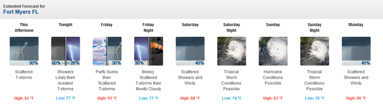
Fort Myers Thursday September forecast.
Lee County wrote on its website on the afternoon of September 7:
“Friday Morning Lee County is planning to announce mandatory evacuation orders for the following areas:
Barrier islands, including Bonita Beach, Fort Myers Beach, Sanibel, Captiva, and Pine Island
Mobile and manufactured homes throughout Lee County.”
These Lee County shelters will open at 9 a.m. Friday September 8:
1. East Lee County High School, 715 Thomas Sherwin Ave., Lehigh Acres
2. Varsity Lakes Middle School, 801 Gunnery Road., Lehigh Acres
3. Harns Marsh Middle School, 1820 Unice Ave. N., Lehigh Acres
4. Oak Hammock Middle School, 5321 Tice St., Fort Myers
5. Island Coast High School, 2125 De Navarra Pkwy., Cape Coral
6. South Ft. Myers High School, 14020 Plantation Road., Fort Myers
7. Estero Rec Center, 9200 Corkscrew Palms Road., Estero
The county’s website has an interactive map in which you can select layers for open shelters, evacuation routes, active evacuations, and evacuation zones.
However, some recent models – such as the so-called “spaghetti models” showed a slight shift to the east on September 6 and 7, which would obviously be good news for Fort Myers. You can see more of those here.
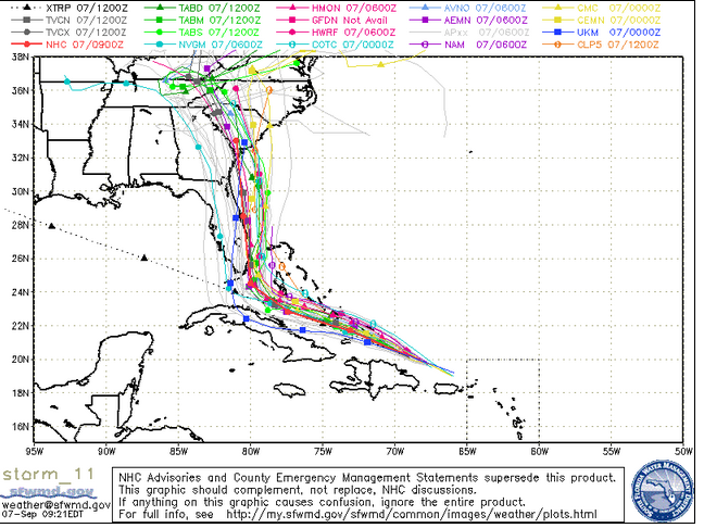
South Florida Waste Management DistrictThursday morning spaghetti model.
Fort Myers is not taking any chances, though. It’s important to remember that the storm remains very unpredictable.
Residents of Fort Myers are stocking up on sandbags just in case. “Residents and businesses owners in the City of Fort Myers have sandbags available to them beginning Tuesday afternoon,” reported Fox 4. “A limit of 20 bags per vehicle will be in effect. The city says free self-service sandbags available for City of Fort Myers residents and business owners.”
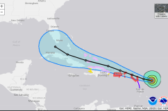
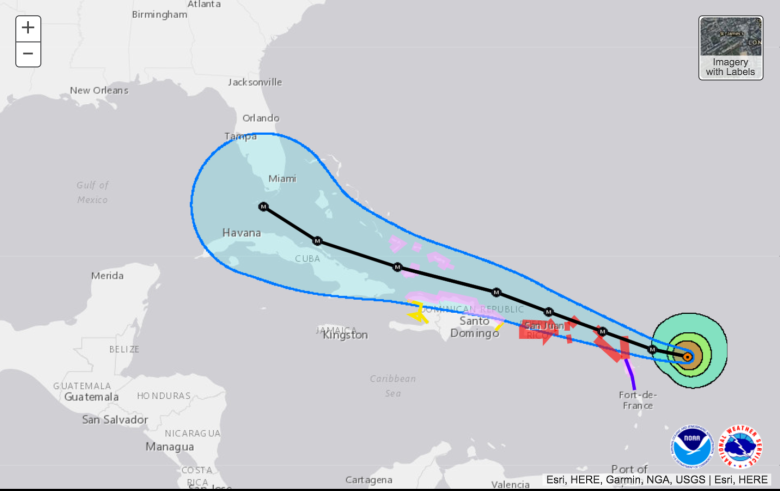
The city remains in the hurricane’s cone. Here’s the September 7 morning track from the National Weather Service:
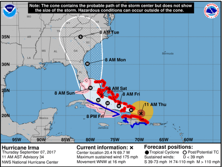
NWSThe Hurricane Irma forecast for 11 a.m. on Thursday, September 7.
The hurricane made landfall in Barbuda, and chances are increasing that it will strike the Florida Keys and southern Florida. Mandatory evacuations are being ordered in the Keys, and the governor of Florida has issued a state of emergency declaration.
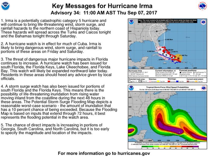
Key Messages on Hurricane #Irma as of 11 am AST/EDT:
The issue for Fort Myers is that it’s not clear what the storm will do after that point.
“It’s already the strongest hurricane ever recorded outside the Caribbean and the Gulf of Mexico, and it’s likely to make landfall somewhere in Florida over the weekend,” The Washington Post reported.
“All of Florida — especially South Florida and the Keys — should be preparing for a major hurricane landfall on Sunday. Tropical-storm-force winds are expected to arrive as soon as Friday.” The Post noted of the storm’s unpredictability: “Computer models are in strong agreement that by Saturday, Irma will be approaching the Florida Keys — where dangerous storm conditions are likely. Then, they show a sharp northward turn by Sunday morning. The precise timing and location of the turn has huge implications for Florida.” It’s not clear how the storm will track after that, The Post reported – east Florida, west Florida or straight up into the state.
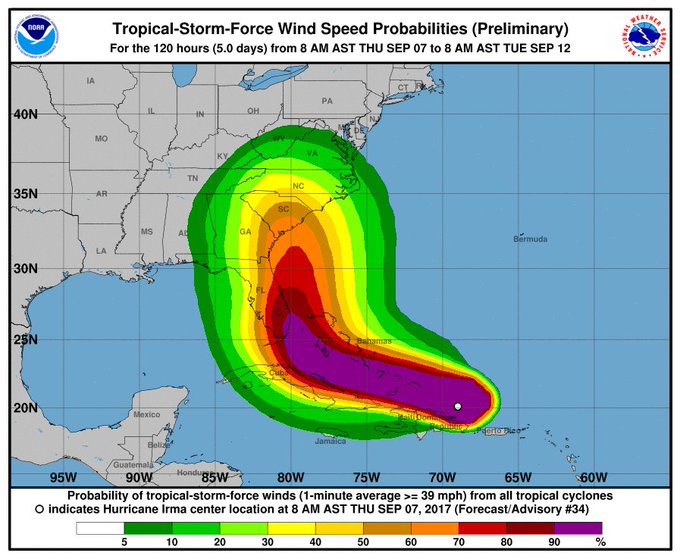
Don’t focus on the exact track of #Irma. There is a high probability of trop storm and hurricane conditions well away from the center.
See updated weather information for Fort Myers here. Be aware that the city’s forecasts are handled by the Tampa Bay office of the National Weather Service. See updated radar for the Fort Myers area here. See infrared satellite maps here. See hourly weather forecast details here.
See the updated information on Hurricane Irma from the National Hurricane Center here.
The hazardous weather outlook for the Fort Myers area said on September 7:
“DAYS TWO THROUGH SEVEN…Friday through Wednesday…THUNDERSTORM IMPACT…Scattered thunderstorms are expected. Thunderstorms will be capable of producing strong gusty winds…locally heavy rains…and frequent deadly lightning strikes…TROPICAL IMPACTS…There is the potential for high winds, marine impacts, river flooding, and other hazards possible with Hurricane Irma in the Friday through Tuesday time frame.”
Here’s the detailed weather forecast for Fort Myers from the National Weather Service:
“This Afternoon (September 7)
Scattered showers and thunderstorms after 2pm. Mostly cloudy, with a high near 92. Heat index values as high as 101. North wind 3 to 5 mph. Chance of precipitation is 30%.
Tonight
Showers and thunderstorms likely, mainly before 11pm. Mostly cloudy, with a low around 77. Northeast wind 5 to 8 mph. Chance of precipitation is 60%. New rainfall amounts between a tenth and quarter of an inch, except higher amounts possible in thunderstorms.
Friday
Scattered showers and thunderstorms after 2pm. Mostly cloudy, with a high near 91. Heat index values as high as 100. Northeast wind around 11 mph, with gusts as high as 21 mph. Chance of precipitation is 30%.
Friday Night
Scattered showers and thunderstorms before 8pm. Mostly cloudy, with a low around 77. Breezy, with a northeast wind 13 to 16 mph, with gusts as high as 20 mph. Chance of precipitation is 30%.
Saturday
Scattered showers and thunderstorms. Mostly cloudy, with a high near 88. Windy, with a northeast wind 20 to 25 mph, with gusts as high as 31 mph. Chance of precipitation is 40%.
Saturday Night
Tropical storm conditions possible. Scattered showers and thunderstorms. Mostly cloudy, with a low around 78. Chance of precipitation is 50%.
Sunday
Hurricane conditions possible. Showers likely and possibly a thunderstorm. Cloudy, with a high near 83. Chance of precipitation is 60%.
Sunday Night
Tropical storm conditions possible. Scattered showers and thunderstorms. Mostly cloudy, with a low around 76. Chance of precipitation is 50%.
Monday
Scattered showers and thunderstorms. Partly sunny, with a high near 86. Windy, with a west wind 21 to 26 mph, with gusts as high as 37 mph. Chance of precipitation is 40%.
Monday Night
Isolated showers and thunderstorms. Partly cloudy, with a low around 75. Chance of precipitation is 20%.
Tuesday
Isolated showers and thunderstorms. Mostly sunny, with a high near 88. Chance of precipitation is 20%.
Tuesday Night
Partly cloudy, with a low around 76.
Wednesday
Scattered showers and thunderstorms. Mostly sunny, with a high near 88. Chance of precipitation is 30%.”