National Hurricane Center
Hurricane Irma is now a Category 5. The storm may not make a landfall in the U.S. until later this week or this weekend, but many regions in Florida are already preparing. The storm currently has 185 mph winds and the chance of direct impacts from Irma is increasing in the Florida Keys and portions of the Florida peninsula. But as the National Hurricane Center has emphasized, “It is too soon to specify the timing and magnitude of the impacts.”
Here’s everything we know so far about the hurricane’s potential impact in Fort Lauderdale.
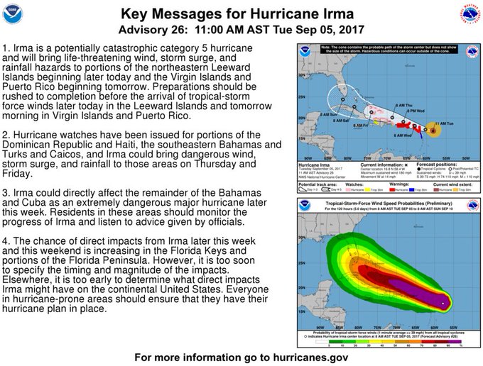
#Irma key messages for Advisory 26. #Hurricane preparations should be rushed to completion in the NE Caribbean. t.co/tW4KeGdBFb
Governor Rick Scott has declared a State of Emergency to prepare for the storm in Florida.
In a statement, Scott said:
In Florida, we always prepare for the worst and hope for the best and while the exact path of Irma is not absolutely known at this time, we cannot afford to not be prepared. This state of emergency allows our emergency management officials to act swiftly in the best interest of Floridians without the burden of bureaucracy or red tape.”
Category 5 #Irma with 185-mph winds- #Hurricane preparations in the NE Leeward Islands should be nearing completion t.co/tW4KeGdBFb
During a press conference on Tuesday, Broward County Mayor Barbara Sharief said that Broward County might experience tropical storm winds as soon as Friday evening. The county is already getting shelters ready and reaching out to residents with special needs, Fort Lauderdale Daily reported. But shelters should be used as a last resort. If evacuations are ordered, residents will be encouraged to leave the area instead.
Beginning at 8 a.m. on Wednesday, the emergency hotline will be open. Residents can call 311 or 954-831-4000.
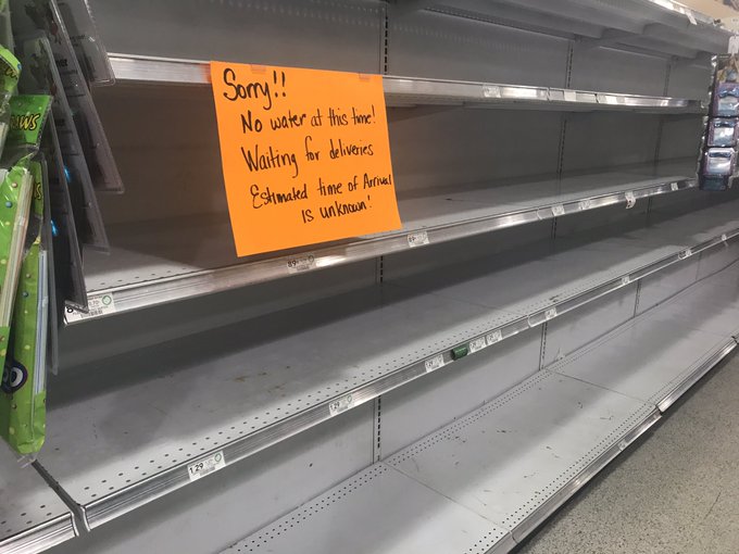
Right now, residents are advised to finalize their emergency plans and prepare for the storm today, including making sure you have enough food, water, gas, and medications. Some stores are already running out of supplies, like a Publix in Davie near Fort Lauderdale, which posted a sign saying it was out of water and not sure when new supplies would arrive.
This is #SouthFlorida right now. Cat 5 headed for us and water delivery at @Publix is “unknown”. #Irma #HurricaneIrma
But don’t trim your trees anymore, because items left on the side of the road could cause damage when wind increases. If you live in an evacuation zone, figure out now where you’ll evacuate to, such as staying with friends or family outside of the zone. At the time of publication, Broward County was holding off on issuing evacuations.
At the time of publication, Ford Lauderdale-Hollywood International Airport and Port Everglades are operating normally. Broward County public schools will be closed Thursday and Friday.
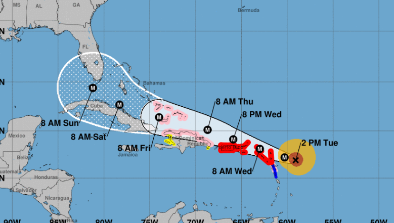
Here is the latest forecast track on #Irma
The National Hurricane Center has indicated that the Leeward Islands will get hit with catastrophic winds tonight, and Irma may reach Puerto Rico and the Virgin Islands on Wednesday night, and then the Dominican Republic and Haiti 24 hours after that. It will then move over Cuba by Friday. Beyond that, it’s tough to predict where the storm will go, but South Florida — especially the Keys — are more and more likely to be in its path.
Florida is on high alert after the damage that was done when Hurricane Harvey, a Category 4, made landfall in Texas. Irma is a Category 5.
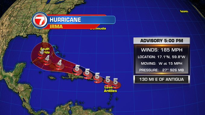
Irma is currently moving west at 14 mph. Experts are urging caution about paying too much heed to the storm’s track and landfall, since it’s 120 miles across (nearly as wide as Florida itself) and many areas will feel the impact of the storm even if they aren’t directly hit by the center of the storm. Tropical storm force winds will extend out 160 miles.
As of 2 p.m., Irma was located near latitude 16.9 North, longitude 59.1 West, heading west at 14 mph. Irma’s strength may change as it moves forward, but experts say it will likely remain Category 5 or 4. Maximum sustained winds were 185 mph. The latest minimum central pressure was 926 mb.
The following watches and warnings were in effect:
A Hurricane Warning is in effect for…
- Antigua, Barbuda, Anguilla, Montserrat, St. Kitts, and Nevis
Saba, St. Eustatius, and Sint Maarten
Saint Martin and Saint Barthelemy
British Virgin Islands
U.S. Virgin Islands
Puerto Rico, Vieques, and Culebra
A Hurricane Watch is in effect for…
- Guadeloupe
Dominican Republic from Cabo Engano to the northern border with
Haiti
Haiti from the northern border with the Dominican Republic to Le
Mole St. Nicholas
Turks and Caicos Islands
Southeastern Bahamas
A Tropical Storm Warning is in effect for…
- Guadeloupe
- Dominica
A Tropical Storm Watch is in effect for…
- Dominican Republic from south of Cabo Engao to Isla Saona
- Haiti from south of Le Mole St. Nicholas to Port-Au-Prince
Here’s the current long range forecast for Fort Lauderdale, according to the National Weather Service. This will likely change as the hurricane’s path becomes more predictable.
Floridians are asked to visit FloridaDisaster.org/GetAPlan to plan ahead for the storm.
If you’re in Broward County and want to stay updated, text ALERTBROWARD to 888-777.