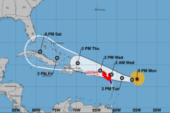
NOAA Hurricane Irma's projected path as of Monday, September 4, 11:00 AST.
Hurricane Irma is still days away from possibly making landfall in Florida, but Governor Rick Scott has already declared a State of Emergency to prepare for it. The hurricane, which comes on the heels of the devastating Hurricane Harvey that hit Texas late last month, is already a Category 5 as it reaches the northern Leeward Islands. The storm could reach Jacksonville and the rest of Florida by Sunday.
FOR THE LATEST UPDATES ON JACKSONVILLE, CLICK HERE.
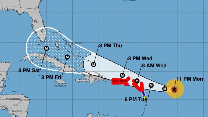
NOAAThe NHC’s projection for Hurricane Irma as of Tuesday at 5 p.m. AST.
The potential track from the National Oceanic and Atmospheric Administration shows Hurricane Irma reaching Puerto Rico by 2:00 p.m. Wednesday, then passing by the Dominican Republic and Haiti 24 hours later. Beyond that, the projection has it moving over Cuba on Friday with the outer bands of the hurricane reaching the Florida keys by Sunday.
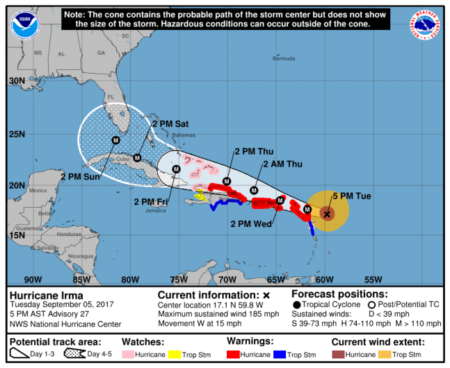
The NOAA reported in its bulletin at 5:00 p.m. AST Monday that Hurricane Irma is a Category 5 Hurricane, with maximum sustained winds at 185 mph. It is moving west at 15 mph.
If #Irma is going to impact Florida, odds are elevated for isolated tornadoes Sunday during landfall. Just another thing to consider.
Considering the damage done by Hurricane Harvey to Texas after making landfall as a Category 4 hurricane, Scott was quick to announce a State of Emergency for all 67 Florida counties, including First Coast counties Duval, Clay, Baker, Flagler, Nassau, Putnam and St. Johns.
The latest Calibrated ECMWF Ensembles indicate a 40% chance for Major Hurricane Force Winds in South Florida via #Irma next weekend/week

“In Florida, we always prepare for the worst and hope for the best and while the exact path of Irma is not absolutely known at this time, we cannot afford to not be prepared. This state of emergency allows our emergency management officials to act swiftly in the best interest of Floridians without the burden of bureaucracy or red tape,” Scott said in a statement.
https://twitter.com/MJVentrice/status/904852718749192192
Although the most recent projection does not have the storm making a direct hit on Jacksonville and the First Coast, residents still need to prepare for it. After all, last year’s Hurricane Matthew caused major damage in the area, particularly in St. Augustine. Matthew also taught residents that a storm doesn’t have to make landfall to make leave a significant impact.
“[I’m] paying very close attention to Irma. [I’m] just really concerned about our friends here in Jacksonville, and also concerned about what’s going to happen,” beachgoer Leland Roane told Action News Jax at Jacksonville Beach.
Jacksonville Beach Ocean Rescue lifeguard Max Ervanian added, “We’re not going to necessarily get 45 lifeguards here on the beach for a system like that only because there’s only so many guards that we have available at the time of the year, but we definitely do keep our eye and staff accordingly, per the ocean conditions, beach population and available staffing.”
To plan ahead, Floridians are urged to visit FloridaDisaster.org/GetAPlan, which helps families and businesses plan for hurricane floods and other damage.
“In Florida, we know that the best way to protect our families in severe weather is to have a plan. I urge all Floridians to remain vigilant and stay alert to local weather and news and visit FLGetAPlan.com today as we all prepare for Hurricane Irma,” the governor said. “We will keep monitoring and issuing updates on Hurricane Irma as it approaches Florida.”
For more updates on Irma, visit NHC.NOAA.gov/#imra.
Here’s the long-range forecast for Jacksonville from the National Weather Service:
Wednesday: A 40 percent chance of showers and thunderstorms after 8am. Cloudy, with a high near 89. Southwest wind 6 to 8 mph.
Wednesday Night: A 30 percent chance of showers and thunderstorms before 2am. Mostly cloudy, with a low around 72. Southwest wind 5 to 7 mph.
Thursday: Partly sunny, with a high near 86. Northeast wind 7 to 9 mph.
Thursday Night: Partly cloudy, with a low around 73.
Friday: A 30 percent chance of showers and thunderstorms. Partly sunny, with a high near 86.
Friday Night: A 40 percent chance of showers and thunderstorms. Mostly cloudy, with a low around 74.
Saturday: Showers and thunderstorms likely. Mostly cloudy, with a high near 84. Breezy. Chance of precipitation is 70%.
Saturday Night: Showers and thunderstorms likely. Cloudy, with a low around 74. Breezy. Chance of precipitation is 70%.
Sunday: Showers and thunderstorms. High near 83. Windy. Chance of precipitation is 80%.
Sunday Night: Showers and possibly a thunderstorm. Low around 73. Very windy. Chance of precipitation is 80%.
Monday: Showers and possibly a thunderstorm. High near 83. Very windy. Chance of precipitation is 80%.