National Hurricane Center
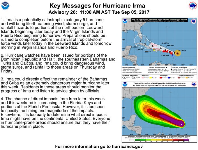
Hurricane Irma is now a Category 5 and evacuations may begin in parts of Miami as soon as Wednesday, even though the storm’s exact path isn’t yet known. Irma may not make a possible landfall in the U.S. until later this week or this weekend. The storm currently has 185 mph winds and the chance of direct impacts from Irma is increasing in the Florida Keys and portions of the Florida peninsula. But as the National Hurricane Center has emphasized, “It is too soon to specify the timing and magnitude of the impacts.”
Here’s everything we know so far about the hurricane’s potential impact in Miami.
Some Areas of Miami May Be Evacuated as Early as Wednesday
#Irma key messages for Advisory 26. #Hurricane preparations should be rushed to completion in the NE Caribbean. t.co/tW4KeGdBFb
Governor Rick Scott has already declared a State of Emergency to prepare for the storm in Florida.
In a statement, Scott said:
In Florida, we always prepare for the worst and hope for the best and while the exact path of Irma is not absolutely known at this time, we cannot afford to not be prepared. This state of emergency allows our emergency management officials to act swiftly in the best interest of Floridians without the burden of bureaucracy or red tape.”
Evacuations in Miami will begin as early as Wednesday.
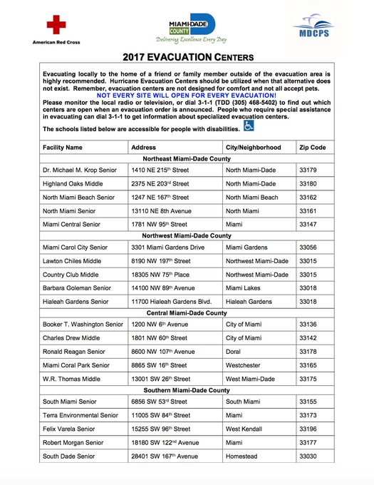
Mayor Carlos Giminez announced that Zones A and B in Miami may begin evacuations as early as late Wednesday or Thursday, ABC 10 reported. Special needs evacuations will begin Wednesday morning and shelters will open starting Wednesday evening. Giminez urged residents to only view shelters as a last resort. Although evacuations will be mandatory, police will not be going door-to-door to check on residents.
To know if your area is being evacuated in Miami, type your address into the web link here.
#Miami, type your address in link to know if and when you should evacuate and the evacuation centers nearest you: t.co/aCI37vRbF9
Gimenz also urged anyone considering visiting south Florida to wait, and anyone currently vacationing there should leave before the storm. He declared a state of emergency for Miami-Dade County this afternoon.
This is a powerful storm which poses a serious threat to our area. I would rather inconvenience residents on this occasion than suffer any loss of life.”
Hurricane Irma’s Movement & Forecast
Category 5 #Irma with 185-mph winds- #Hurricane preparations in the NE Leeward Islands should be nearing completion t.co/tW4KeGdBFb
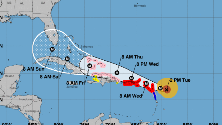
The National Hurricane Center has indicated that the Leeward Islands will get hit with catastrophic winds tonight, and Irma may reach Puerto Rico and the Virgin Islands on Wednesday night, and then the Dominican Republic and Haiti 24 hours after that. It will then move over Cuba by Friday and the outer bands will reach the Florida Keys by Saturday. Beyond that, it’s tough to predict where the storm will go, but South Florida — especially the Keys — are more and more likely to be in its path.
Florida is on high alert after the damage that was done when Hurricane Harvey, a category 4, made landfall in Texas. Irma is a Category 5.
Irma is currently moving west at 14 mph. Experts are urging caution about paying too much heed to the storm’s track and landfall, since it’s 120 miles across (nearly as wide as Florida itself) and many areas will feel the impact of the storm even if they aren’t directly hit by the center of the storm. Tropical storm force winds will extend out 160 miles.
As of 2 p.m., Irma was located near latitude 16.9 North, longitude 59.1 West, heading west at 14 mph. Irma’s strength may change as it moves forward, but experts say it will likely remain Category 5 or 4. Maximum sustained winds were 185 mph. The latest minimum central pressure was 926 mb.
The following watches and warnings were in effect:
A Hurricane Warning is in effect for…
- Antigua, Barbuda, Anguilla, Montserrat, St. Kitts, and Nevis
Saba, St. Eustatius, and Sint Maarten
Saint Martin and Saint Barthelemy
British Virgin Islands
U.S. Virgin Islands
Puerto Rico, Vieques, and Culebra
A Hurricane Watch is in effect for…
- Guadeloupe
Dominican Republic from Cabo Engano to the northern border with
Haiti
Haiti from the northern border with the Dominican Republic to Le
Mole St. Nicholas
Turks and Caicos Islands
Southeastern Bahamas
A Tropical Storm Warning is in effect for…
- Guadeloupe
- Dominica
A Tropical Storm Watch is in effect for…
- Dominican Republic from south of Cabo Engao to Isla Saona
- Haiti from south of Le Mole St. Nicholas to Port-Au-Prince
Miami Forecast & Cancellations
Miami-Dade County offices will be closed Thursday and Friday. Public schools in Miami-Dade county will be closed Thursday and Friday. Extracurricular and night classes will be closed starting Wednesday.
Miami-Dade County @MayorGimenez announces evacuations will begin tomorrow due to #Irma. County offices will be closed Thursday and Friday
The University of Miami is cancelling all classes for the rest of the week.
The University of Miami has canceled all classes for the remainder of the week, starting Wednesday, in response to Irma.
And here is more cancellation news, according to WSVN:
- Miami-Dade college is monitoring Irma.
- Florida International University is monitoring Irma.
- Monroe County schools closed Wednesday, Sept. 6, until further notice
- Basilica School of St. Mary Star of the Sea will be closed Wednesday, Sept. 6 through Monday, Sept. 11
- Belen Jesuit Preparatory School will be closed Thursday and Friday.
- Monroe County will close its government offices on Wednesday, Sept. 6
- Monroe County will close county parks on Wednesday.
- Many other events and activities are being cancelled, including cruises, a Miami International Auto Show (postponed), and other city events. The NFL is still deciding about the Miami Dolphins season opening game, which is scheduled for Sunday.
Here’s the current long range forecast for Miami, according to the National Weather Service. This could change as the hurricane’s path becomes more predictable.
- Wednesday: A 40 percent chance of showers and thunderstorms. Partly sunny, with a high near 87. Southeast wind 5 to 11 mph.
- Wednesday Night: A 30 percent chance of showers and thunderstorms. Mostly cloudy, with a low around 82. East wind 3 to 6 mph.
- Thursday: A 50 percent chance of showers and thunderstorms. Partly sunny, with a high near 89. Light east wind increasing to 5 to 9 mph in the morning.
- Thursday Night: A 40 percent chance of showers and thunderstorms. Mostly cloudy, with a low around 82. East wind 8 to 10 mph.
- Friday: A 50 percent chance of showers and thunderstorms. Partly sunny, with a high near 88. Breezy, with a northeast wind 16 to 20 mph, with gusts as high as 28 mph.
- Friday Night: Tropical storm conditions possible. Showers likely and possibly a thunderstorm. Mostly cloudy, with a low around 82. Chance of precipitation is 60%.
- Saturday: Hurricane conditions possible. Showers likely and possibly a thunderstorm. Mostly cloudy, with a high near 87. Chance of precipitation is 70%.
- Saturday Night: Hurricane conditions possible. Showers likely and possibly a thunderstorm. Cloudy, with a low around 81. Chance of precipitation is 70%.
- Sunday: Showers likely. Cloudy, with a high near 87. Windy. Chance of precipitation is 70%.
- Sunday Night: Showers likely and possibly a thunderstorm. Cloudy, with a low around 80. Windy. Chance of precipitation is 70%.
- Monday: A 40 percent chance of showers and thunderstorms. Mostly cloudy, with a high near 88. Windy.
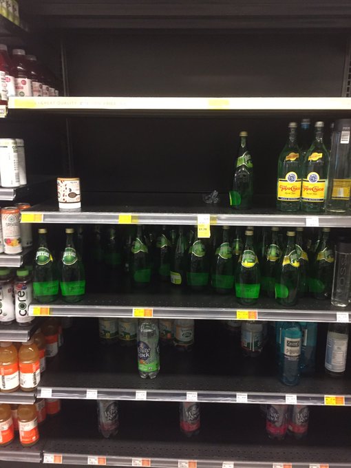
Stock up on supplies soon, as many areas are already out:
For a minute, I thought I was back in Caracas… but this is in Miami as #Irma approaches. At least there is still Perrier!

Floridians are asked to visit FloridaDisaster.org/GetAPlan to plan ahead for the storm.