National Hurricane Center
Hurricane Irma is a Category 5 packing 185 mph winds and could be one of the biggest storms in recent history, and Miami could be right in the center of its path. The hurricane has already left extensive destruction in its wake, as it tore through areas like the tiny island of Barbuda, which was left with 90 percent of its structures damaged. Now it’s heading to the Dominican Republic and the Bahamas, moving at about 16 mph.
Here’s everything we know so far about the hurricane’s potential impact in Miami.
Mandatory Evacuations Have Already Been Ordered for Parts of Miami-Dade County
#Update: @MayorGimenez has declared mandatory evacuation on Zones A & -barrier islands- of Zone B. Refer to map below. #HurricaneIrma
Mandatory evacuations have been ordered for Zone A, Zone B barrier islands, and all mobile homes. The Miami Herald reports that this could be Miami-Dade’s first major evacuation in 12 years.
#HurricaneIrma: Mandatory evacuation ordered for all Miami-Dade residents of zone A and barrier islands of zone B (Miami Beach included).
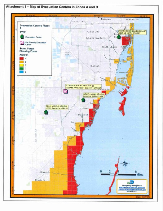
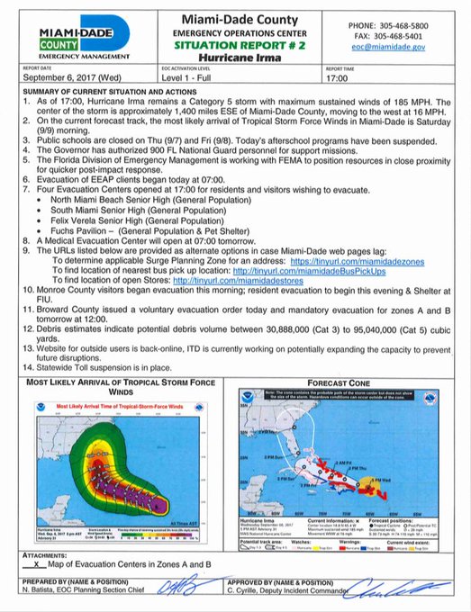
Special needs evacuations began Wednesday morning and shelters started opening Wednesday evening. Mayor Carolos Giminez urged residents to only view shelters as a last resort. Although evacuations will be mandatory, police will not be going door-to-door to check on residents.
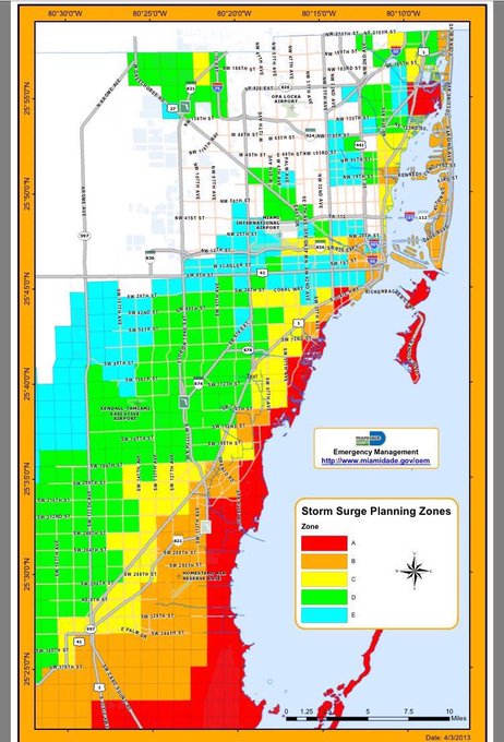
To know if your area is being evacuated in Miami, type your address into the web link here. Zone A includes most of Coastal Miami-Dade, and Zone B includes Miami Beach.
Mayor Phillip Levine on #Irma: Get out of Miami Beach. Now
Gimenz also urged anyone considering visiting south Florida to wait, and anyone currently vacationing there should leave before the storm. He declared a state of emergency for Miami-Dade County on Tuesday afternoon.
This is a powerful storm which poses a serious threat to our area. I would rather inconvenience residents on this occasion than suffer any loss of life.”
Patch.com reported that communities affected by the mandatory evacuation order include:
- Bal Harbour
- Bay Harbor Islands
- Biscayne Park
- Golden Beach
- Indian Creek Village
- Miami Beach
- North Bay Village
- Sunny Isles Beach
- Surfside
- Key Biscayne
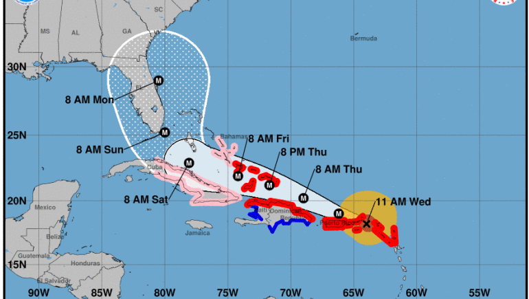
Hurricane Irma’s Movement & Forecast
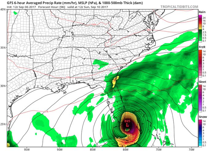
12z GFS not a good look for SE Florida…certainly more corrections coming, but models seem to be zeroing in.
At 5 p.m., the National Hurricane Center in Miami released its latest projection for Hurricane Irma.
Here are the latest Key Messages for #Irma advisory 31 t.co/tW4KeGdBFb
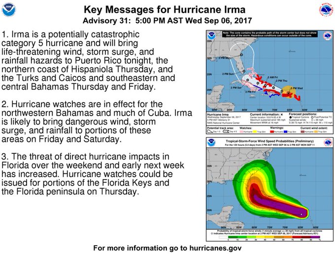
Unfortunately, the latest 5 pm advisory stated:
The threat of direct hurricane impacts in Florida over the weekend and early next week has increased. Hurricane watches could be issued for portions of the Florida Keys and the Florida peninsula on Thursday.”
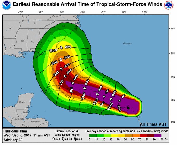
And here are the latest estimates on when to expect tropical storm force winds:
9/6 2pm: Latest estimates of when tropical-storm-force winds could arrive & are most likely to arrive with #Irma t.co/tW4KeGdBFb

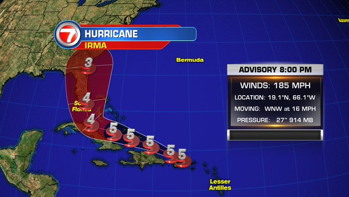
As of 8 p.m., Irma was located at 19.1 N 66.1 W, the National Hurricane Center reported, about 50 miles N of San Juan Puerto Rico, with maximum sustained winds of 185 mph, moving WNW at 16 mph.
Here is the latest forecast track on #Irma
The following watches and warnings are in effect:
A Hurricane Warning is in effect for…
- British Virgin Islands
U.S. Virgin Islands
Puerto Rico, Vieques, and Culebra
Dominican Republic from Cabo Engano to the northern border with
Haiti
Haiti from the northern border with the Dominican Republic to Le
Mole St. Nicholas
Southeastern Bahamas and the Turks and Caicos Islands
Central Bahamas
A Hurricane Watch is in effect for…
- Cuba from Matanzas province eastward to Guantanamo province
Northwestern Bahamas
A Tropical Storm Warning is in effect for…
- Dominican Republic from south of Cabo Engano westward to the
southern border with Haiti
Haiti from south of Le Mole St. Nicholas to Port-Au-Prince
Cuba provinces of Guantanamo, Holguin, and Las Tunas
Miami Forecast & Emergency Preparations

For a full list of what is open and closed in the area, see WSVN here.
Residents are already preparing, so if you’re not stocked up on emergency supplies already, you need to do so right away, as many areas are already out.
Miami area shelters are already sending their dogs and cats to California.
Here’s the current long range forecast for Miami, according to the National Weather Service. This could change as the hurricane’s path becomes more predictable.
-
Thursday: A 30 percent chance of showers and thunderstorms, mainly after 2pm. Partly sunny, with a high near 87. Light northeast wind becoming east 5 to 10 mph in the morning.Thursday Night: A 30 percent chance of showers and thunderstorms, mainly before 2am. Mostly cloudy, with a low around 81. East wind around 9 mph.Friday: A 40 percent chance of showers and thunderstorms, mainly after 2pm. Partly sunny, with a high near 87. Windy, with a northeast wind 14 to 21 mph, with gusts as high as 29 mph.Friday Night: Tropical storm conditions possible. A chance of showers and thunderstorms, then showers likely and possibly a thunderstorm after 8pm. Mostly cloudy, with a low around 82. Chance of precipitation is 60%.Saturday: Hurricane conditions possible. Showers likely and possibly a thunderstorm. Cloudy, with a high near 86. Chance of precipitation is 70%.Saturday Night: Hurricane conditions possible. Showers likely and possibly a thunderstorm. Cloudy, with a low around 79. Chance of precipitation is 70%.Sunday: Hurricane conditions possible. Showers likely and possibly a thunderstorm. Cloudy, with a high near 86. Chance of precipitation is 70%.Sunday Night: Hurricane conditions possible. Showers likely and possibly a thunderstorm. Cloudy, with a low around 79. Chance of precipitation is 70%.Monday: A 50 percent chance of showers and thunderstorms. Mostly cloudy, with a high near 88. Windy.Monday Night: A 20 percent chance of showers and thunderstorms. Partly cloudy, with a low around 79. Breezy.Tuesday: A 30 percent chance of showers and thunderstorms. Mostly sunny, with a high near 89.Tuesday Night: A 20 percent chance of showers and thunderstorms. Partly cloudy, with a low around 80.Wednesday: A 40 percent chance of showers and thunderstorms. Partly sunny, with a high near 88.
Floridians are asked to visit FloridaDisaster.org/GetAPlan to plan ahead for the storm.
For details on the Emergency & Evacuation Assistance Program, which is designed to help individuals who need help evacuating, click here.