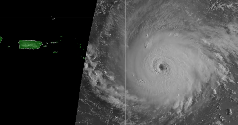
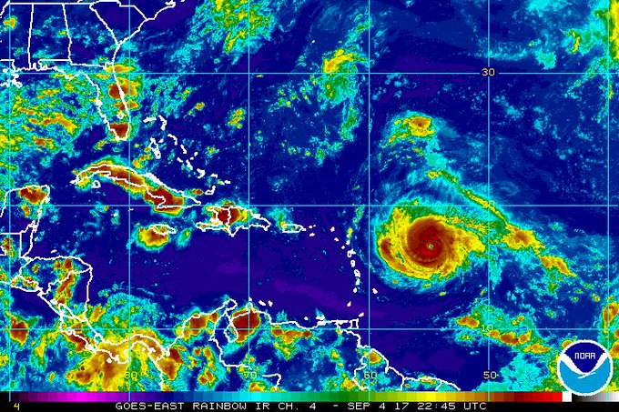
National Weather Service Hurricane Irma on September 5.
The governor of Puerto Rico declared a state of emergency on September 4 in advance of Hurricane Irma, which is now a Category 5 storm.
“The National Guard was also activated as the U.S. territory prepares for the storm to hit on Wednesday,” according to Fox News. A hurricane watch had been declared for Puerto Rico. The dangerous storm has winds reaching 175 mph.
8 am Special Advisory: #Irma is now a category 5 #hurricane with maximum sustained winds of 175 mph (280 km/h) More: t.co/tW4KeGdBFb
The extended forecast shows hurricane conditions for Wednesday and Thursday in San Juan:
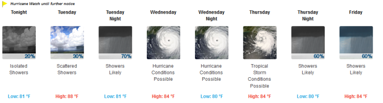
The weather forecast for San Juan, Puerto Rico.
You can track Irma’s path here. Track the latest radar for Puerto Rico here and here.


See an hourly forecast for San Juan here.
Key Messages on Category 5 Hurricane #Irma for 8am EDT
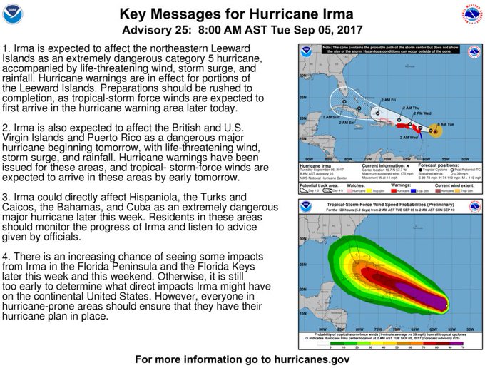
“Irma is expected to remain as a major hurricane as it approaches Puerto Rico and the U.S Virgin Islands late Wednesday morning,” the NWS said. “Irma is expected to move northeast of the local isles Wednesday afternoon through early Thursday Morning. Irma could cause dangerous winds, storm surge and rainfall impacts across the local isles.”
The storm’s details as of the morning of September 5:
STORM INFORMATION:
– About 560 miles east of San Juan PR or about 490 miles
east-southeast of Saint Thomas VI
– 16.7N 57.7W
– Storm Intensity 175 mph
– Movement West or 280 degrees at 14 mph
“Irma has increased in strength to Category 5 with winds of 175 mph and is expected to continue as a major hurricane as it approaches Puerto Rico and the U.S Virgin Islands late Wednesday morning,” The National Weather Service said. Irma is expected to move just northeast of the local islands Wednesday through Thursday. Irma is expected to cause dangerous winds, storm surge, rip currents and rainfall impacts across the local islands. Hurricane force wind are possible across the Northern U.S. Virgin Islands, Culebra, Vieques and Northeast Puerto Rico with strong tropical force winds likely elsewhere. Wind gusts with hurricane force wind are likely at higher elevations. Rainfall accumulations between 4 to 8 inches with isolated amounts of 12 inches or greater likely Wednesday through Friday.”
Here’s the hurricane’s path as of the evening of September 5:
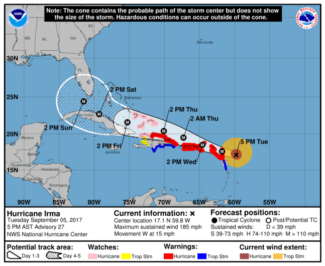
NOAAThe NHC’s projection for Hurricane Irma as of Tuesday at 5 p.m. AST.
Puerto Ricans should prepare for “hurricane force wind gusts” that are “possible across Northern U.S. Virgin Islands, Culebra and Northeast Puerto Rico with strong tropical force winds likely,” the National Weather Service said.
Key Messages for #Irma advisory 21. t.co/tW4KeGdBFb
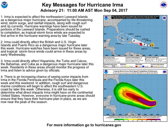
According to NWS, “The rest of the area likely to experience tropical storm force winds. Wind gusts with hurricane force wind are likely at higher elevations. Rainfall accumulations between 4 to 8 with isolated amounts over 10 inches likely Wednesday through Thursday.”
People are expressing concern on social media about their families.
The National Weather Service warns Puerto Ricans: “Prepare for life-threatening wind having possible devastating impacts,” including structural damage to buildings and impassable roads, as well as power and communications outages. “Prepare for life-threatening rainfall flooding having possible extensive impacts,” NWS warned.
Some people on social media were upset about what they saw as excessive focus on Florida at the expense of Puerto Rico when it comes to Hurricane Irma.
Florida’s governor has also declared a state of emergency in advance of Hurricane Irma. You can read more about that here: