National Hurricane Center
In the latest Hurricane Irma models and maps, South and North Carolina are not out of the woods. Although it’s impossible to accurately track exactly where a hurricane will go this far out, the center of the storm could track into Georgia, but South and North Carolina could still feel some winds and rains from the storm as early as Sunday.
Here’s what we know so far about when Irma might affect the Carolinas.
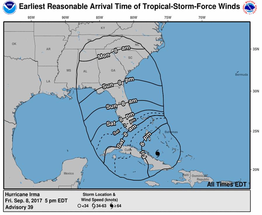
Florida is expected to start feeling tropical storm force winds by Saturday morning, with the hurricane making landfall sometime on Sunday. Meanwhile, the southernmost part of Georgia can expect to start feeling tropical storm force winds by Sunday evening, according to the National Hurricane Center. And South Carolina can start expecting to feel the tropical storm force winds between Sunday night and Monday morning:
National Hurricane Center
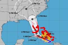
According to this map from the National Hurricane Center, although Georgia is in the cone of probability for the center of the storm, South and North Carolina are barely within that cone. However, this doesn’t mean they are out of the woods and won’t experience any effects from the storm. And the storm’s path could still change between now and then.
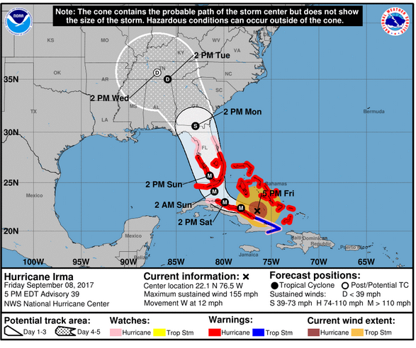
NWSHurricane Irma on Friday September 8 at 5 p.m.
According to Jonathan Belles, a meteorologist with FSU Weather, even when downgraded, those evacuating from the Carolinas should not go to Georgia: “It is a bad idea to evacuate from the Carolinas to Georgia because you could be putting yourself in the way of Hurricane Irma…the whole point of evacuation is to get out of the hurricane, not into it.”
South Carolina, he said, can expect to feel the outer tropical storm force winds on Monday. Hurricane force winds could be felt after that if the states track close enough to Irma’s center.
According to Weather.com, Irma is currently expected to make its closest approach to the Carolinas on Monday, although the center of the storm is currently expected to track through Georgia. Coastal flooding is possible during high tide. And although maximum sustained winds for the storm will decrease as it moves north, there will still be a chance of downed trees and power lines (more so in South than North Carolina.) The South Carolina Coast is still in danger of major coastal flooding during high tide on Sunday and Monday, which might cut off routes from the barrier islands.
South Carolina could also see heavy rain and flooding in some inland regions. Isolated tornadoes are also a possibility in South Carolina Sunday night or Monday.
Continue monitoring the storm’s progress closely, as things can change unexpectedly.