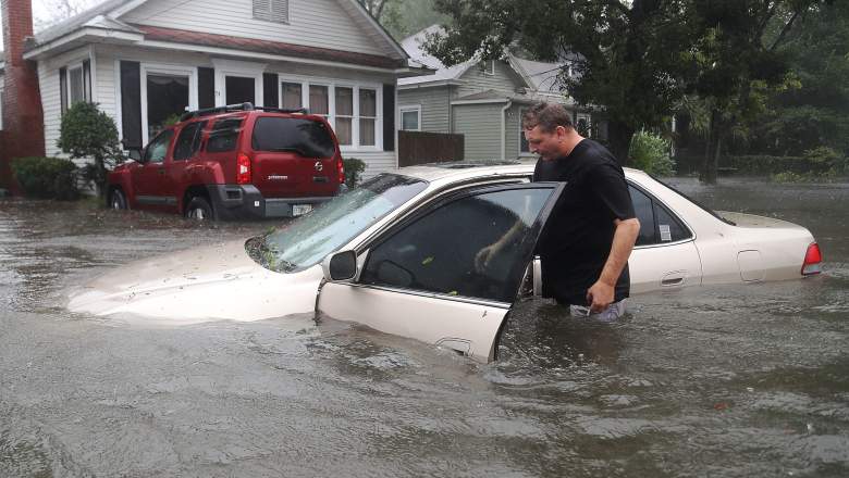
Getty A St. Augustine resident checks out his car after Hurricane Matthew in October 2016.
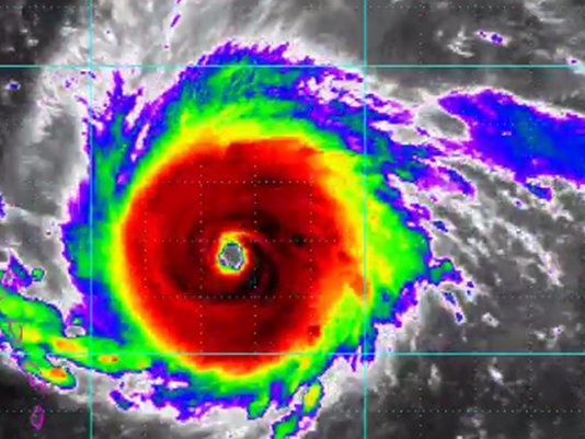
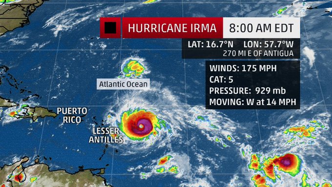
St. Augustine is still rebuilding from last year’s Hurricane Matthew and could face another major storm with Hurricane Irma. The hurricane is not expected to hit Florida until the weekend, but Governor Rick Scott has already declared a State of Emergency for all 67 counties, including St. Johns County. As of Tuesday, Irma is still a Category 5 Hurricane.
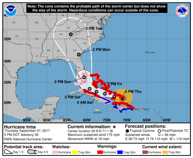
NOAA/NHCHurricane Irma forecast at 5 p.m. ET
UPDATE: St. Johns County has issued mandatory evacuations for 6 a.m. on Saturday for Evacuation Zones A and B. This includes all of St. Augustine and Hastings. The order also includes residents on waterfront property, living in boards, mobile homes and RVs. Here are the shelters that will open at 6 a.m. Saturday:
Pacetti Bay Middle School, 245 Meadowlark Ln. (Special needs)
Timberlin Creek Elementary School, 555 Pine Tree Ln. (Pet-friendly)
Pedro Menendez High School, 600 SR 206 West (General population)
Bartram Trail High School, 7399 Longleaf Pine Pkwy. (General population)
The National Oceanic and Atmospheric Administration reported Wednesday that Irma has maximum sustained winds of 185 mph. It has already passed Antigua, where it made landfall. It’s moving west at 16 mph.
For more information on evacuations in St. Johns County, click here to go to St. Johns County Emergency Management.
BREAKING: Residents in South Florida urged to evacuate ahead of Hurricane Irma
t.co/mWKBY7HtLJ
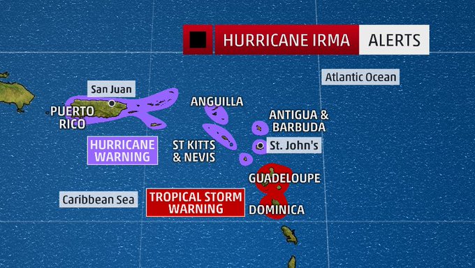
Hurricane Warnings are already in effect for Puerto Rico, the U.S. Virgin Islands, the British Virgin Islands, St. Kitts, Montserrat and other northern Leeward Islands. However, the NOAA warns, “Interests elsewhere in the Dominican Republic and Haiti, as well as Cuba, the central and northwestern Bahamas, and Florida should monitor the progress of Irma.”
Hurricane Irma is now a category 5. Watch The Weather Channel now for Live Coverage and the latest track for Florida.


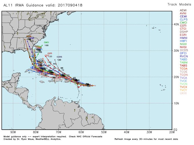
The 11 a.m. AST trajectory map showed Irma reaching South Florida by 8 a.m. Sunday. Scott issued his declaration of a State of Emergency on Monday to give local governments the opportunity to prepare ahead of time to protect residents and make services available. “This state of emergency allows our emergency management officials to act swiftly in the best interest of Floridians without the burden of bureaucracy or red tape,” Scott said.
Big threat from Irma late this weekend for Florida…..no problems here.

The governor also urged residents and business-owners to use FloridaDisaster.org/GetAPlan to start planning for the storm. St. Johns residents can also familiarize themselves with the evacuation zone map. The St. Johns County Emergency Management notes that there could be dangerous rip currents this weekend and heavy rainfall caused by Irma. Officials at the agency note that they are in contact with the Florida Division of Emergency Management, National Weather Service Jacksonville and National Hurricane Center for the latest updates.
Although Hurricane Matthew didn’t make landfall in Florida, St. Augustine was still dealt a punishing blow and some are still rebuilding from that storm 11 months later. In December, St. Augustine officials estimated that the storm caused about $7.1 million in damages.
“A lot of people… they’re still fixing houses over there,” resident Patrick Crofoot told First Coast News. “If you have anything you really want, get it off the ground or take it with you.”
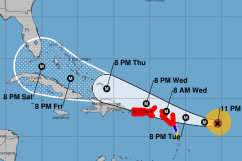
Here’s the forecast for Wednesday through Tuesday from the National Weather Service.
Today: Showers and thunderstorms likely, mainly after 4pm. Cloudy, with a high near 86. Southwest wind 6 to 9 mph. Chance of precipitation is 60%. New rainfall amounts between a tenth and quarter of an inch, except higher amounts possible in thunderstorms.
Tonight: A chance of showers and thunderstorms before 10pm, then a slight chance of showers between 10pm and 1am. Mostly cloudy, with a low around 71. South wind 3 to 6 mph. Chance of precipitation is 30%.
Thursday: A slight chance of showers, with thunderstorms also possible after 2pm. Mostly cloudy, with a high near 84. Northeast wind 6 to 14 mph. Chance of precipitation is 20%.
Thursday Night: A slight chance of thunderstorms before 8pm, then a slight chance of showers and thunderstorms after 11pm. Mostly cloudy, with a low around 73. Northeast wind 7 to 13 mph. Chance of precipitation is 20%.
Friday: A 40 percent chance of showers and thunderstorms. Mostly cloudy, with a high near 85. Breezy, with a northeast wind 13 to 18 mph, with gusts as high as 28 mph.
Friday Night: A 50 percent chance of showers and thunderstorms. Mostly cloudy, with a low around 76. Breezy.
Saturday: Showers likely and possibly a thunderstorm. Cloudy, with a high near 83. Windy. Chance of precipitation is 70%.
Saturday Night: Showers likely and possibly a thunderstorm. Cloudy, with a low around 76. Windy. Chance of precipitation is 70%.
Sunday: Hurricane conditions possible. Showers likely and possibly a thunderstorm. Cloudy, with a high near 83. Chance of precipitation is 70%.
Sunday Night: Showers likely and possibly a thunderstorm. Cloudy, with a low around 74. Very windy. Chance of precipitation is 70%.
Monday: Showers likely and possibly a thunderstorm. Cloudy, with a high near 83. Very windy. Chance of precipitation is 70%.
Monday Night: A 40 percent chance of showers and thunderstorms. Mostly cloudy, with a low around 72. Very windy.
Tuesday: A 30 percent chance of showers and thunderstorms. Partly sunny, with a high near 86. Windy.