National Hurricane Center
Hurricane Irma is currently a Category 4 storm as it moves swiftly toward the Leeward Islands. There is a chance that the storm could strengthen even more, perhaps becoming a Category 5 before making landfall somewhere in the Caribbean — or in the United States.
Governor Rick Scott has issued a state of emergency for Florida, and people all over the Sunshine State have been keeping a very close eye on the storm’s projected path. Although Florida won’t start experiencing any severe weather related to the storm until the weekend (see the map below), just about everyone is prepared for the worst. After seeing the devastation left behind by Hurricane Harvey in Texas — which made landfall as a Category 4 — Floridians are vigilantly engaged in storm preparation.
“Hurricane Irma is a major and life-threatening storm and Florida must be prepared. In Florida, we always prepare for the worst and hope for the best and while the exact path of Irma is not absolutely known at this time, we cannot afford to not be prepared,” the statement read in part.
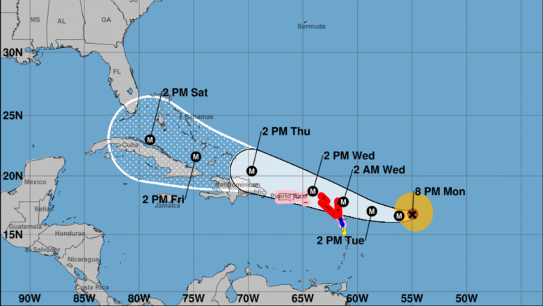
The National Hurricane Center has updated its projection map. The storm’s projected path currently sits just above Cuba, which could be devastating to that area. While the storm looks like it’s going to skirt south of Tampa and head into the Gulf, there is always that fear that the warm waters will cause it to do a sort of U-turn and head right for the city.
Tampa residents won’t know for sure whether or not they will be getting a direct hit until mid-week. The winds are expected to pick up on Friday, with rain to follow. Regardless of whether or not Irma makes landfall in Florida at some point, significant rain is anticipated due to the storm’s feeder bands.
The last major hurricane to hit Tampa was in 1921, which pre-dated the current naming system. Although Tampa has seen its fair share of big storms since then, it hasn’t fallen victim to a direct hit in over nine decades.