National Hurricane Center
Hurricane Maria’s projected path has changed a couple of times over the last few days. The storm has taken a few jogs to the east and a few to the west, making her very unpredictable as she pulls away from the Caribbean.
It is still possible that Maria could affect the East Coast of the United States sometime next week — if the latest models are correct. The latest GFS model has Maria making landfall in North Carolina, and while the European model shows Maria staying a bit further out to sea, the latest run has shown a more western movement. The two models seem to be aligning a bit more today.
Check out one of the most recent GFS runs below.
Next, take a look at the latest European run (as of 2 p.m. Eastern). This model only runs twice a day and is often considered the most accurate model when it comes to predicting the paths of hurricanes. The latest Euro update does seem to be a bit more in line with the GFS update.
Midday Euro run. Very close to North Carolina Friday morning. This is due to upper level winds coming from the SW which will push #Maria out
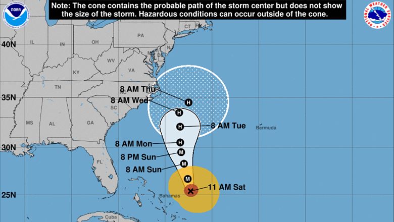
The National Hurricane Center still shows Maria’s path heading east on Thursday, taking her far away from the Outer Banks. However, it is expected that the 5 p.m. advisory will shift the storm back to the west, based on the 2 p.m. Euro run. If this is the case, folks in North Carolina may want to start prepping for some inclement weather that could arrive in the overnight hours of Wednesday into Thursday.
Maria is approximately 245 miles east of Eleuthera Island in the Bahamas. She is moving north northwest at 8 mph. As she travels through the chilly Atlantic Ocean, she is expected to weaken. She will likely be a Category 1 by the time she reaches the Carolinas. Whether or not she makes landfall, however, is still unknown.
“Hurricane Maria, a Category 3 hurricane, may bring direct impacts to portions of the U.S. East Coast next week. Regardless of its exact track, Maria will bring high surf and dangerous rip currents to the U.S. East Coast into next week,” The Weather Channel reports. “The latest forecast path from the National Hurricane Center (NHC) for Maria shows a slight westward shift in the center of the hurricane, as well as a slower forward motion, which could place Maria close to the mid-Atlantic coast midweek,” the site adds.
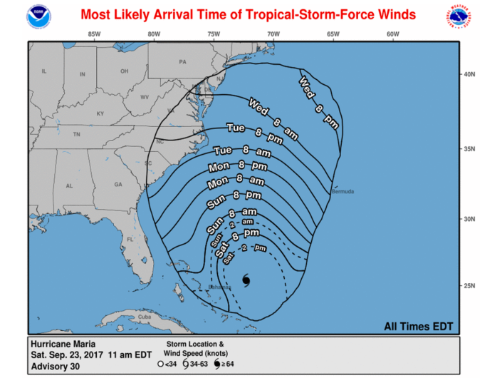
Below is the National Hurricane Center’s map depicting when tropical-storm-force winds could begin impacting the east coast. This map is based on the 11 a.m. advisory, which shows Maria heading out to sea. If the track changes, this map may also change. Check back regularly for updates.