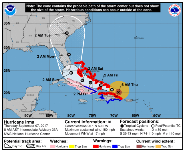
NOAA/NHCNOAA’s Irma projection from 8:00 a.m. ET.
Hurricane Irma is slowly approaching the United States, and many cities in North Carolina are in its latest predicted path.
The Charlotte region is being told by meteorologists to prepare for strong winds and up to 5 inches of rain, which may lead to flooding, beginning early next week. The exact track of Irma isn’t yet concrete, but its latest path shows the storm, which is currently at a Category 5 level, passing through Florida before heading into Georgia. After that, Irma is on track to make landfall in South Carolina before heading into western North Carolina.
With the latest news of Irma’s path, North Carolina Gov. Roy Cooper declared a state of emergency for the entire state starting at 8 a.m. Thursday. At 11 a.m. Thursday, officials announced that a hurricane watch was issued for parts of Florida.
“There remains some uncertainty but confidence is increasing that some portion of our area will be impacted,” the National Weather Service’s Greenville-Spartanburg, S.C., office said to The Charlotte Observer.
North Carolina is officially under a state of emergency ahead of #HurricaneIrma — the latest on preparations #Irma t.co/5sIafZvvOg

The latest forecast says that the impact of Irma is expected to be felt starting Sunday and ramping up Monday into Tuesday. While Irma currently sits at a Category 5 level, it’s likely to be downgraded once it makes landfall and eventually be a tropical storm. The National Weather Service also said that tornadoes are possible with damaging wind gusts and torrential rainfall.
“In a worst case scenario, with the center of Irma passing by to the west of the region, we could see 3 to 5 inches of rain, wind gusts 40 to 60 mph and significant power outages,” WBTV meteorologist Al Conklin wrote.
Here’s the forecast for Charlotte through the weekend, when Irma is set to hit, according to AccuWeather:
Friday: Sunny with a high of 78 degrees with 6 mph NNE winds.
Friday night: Clear with a low of 57 degrees with 5 mph NNE winds.
Saturday: Sunny with a high of 78 degrees with 8 mph NE winds.
Saturday night: Clear with a low of 55 degrees with 8 mph NE winds.
Sunday: Sunny to partly cloudy with a high of 74 degrees with 12 mph NE winds.
Sunday night: Plenty of clouds with a low of 59 degrees with 12 mph NE winds.
Monday: Wind and rain from Irma in the afternoon with a high of 67 degrees with 28 mph NE winds with 46 mph gusts.
Monday night: Low of 60 degrees. Irma brings torrential rain and strong winds which may lead to flooding. Winds at 43 mph ENE with gusts at 54 mph.
Tuesday: A little rain and wind possible with a high of 71 degrees. Winds at 16 mph SSE with gusts reaching 29 mph.
Tuesday night: Clear with a low of 58 degrees. Winds at 6 mph S with gusts at around 10 mph.
For more information and the latest on Irma’s track, click here.
While Charlotte officials monitor Irma and make preparations, residents can’t help but remember Hurricane Hugo in 1989. The storm was a similar Category 5 hurricane to Irma that devastated parts of Florida, Georgia, the Carolinas, the mid-Atlantic and New England.
Hugo hit Charleston, South Carolina and then moved through Charlotte in September 1989. The strong winds brought widespread power outages and knocked down trees in the Charlotte area.
Click here for important information on being prepared for Irma and potential evacuation routes from those in North Carolina.