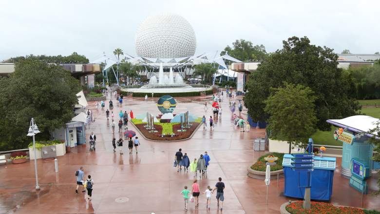
Getty EPCOT after it closed on October 6 for Hurricane Matthew.
Hurricane Irma is moving closer to Florida and should arrive on Sunday. Although the latest projection from the National Hurricane Service has the storm moving eastward when it takes its turn north to Florida, it will still bring rains to Walt Disney World and the Orlando area. Here’s the latest forecast for the theme park, where thousands are on vacation each day.
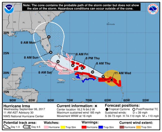
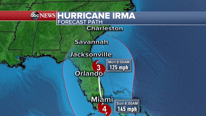
NOAA/NHSThe National Hurricane Center’s Hurricane Irma track, as of 11:00 a.m. AST.
At 11:00 a.m., the National Hurricane Center in Miami released a new projection, showing Irma taking a turn north towards Florida at around 8 a.m. Saturday morning. It will not reach Florida until 8 a.m. Sunday. Thanks to a “Bermuda High,” it appears that Irma will turn eastward and away from Florida. However, it will still bring heavy winds and rains to the area.
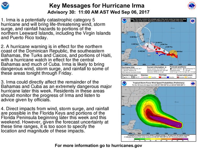
11 AM AST key messages for #Irma. Latest information at t.co/tW4KeGdBFb
In a public advisory, the NHC reports that Irma is still a Category 5 hurricane and has sustained winds of 185 mph.
Florida has been under a State of Emergency since Governor Rick Scott issued an executive order on Monday. Since then, Scott has activated 100 members of the Florida National Guard to help with preparations and suspended all tolls on Florida highways. President Donald Trump also declared a federal emergency for Florida.
Hurricane Irma on Florida track: Evacuations, closures, road conditions; cruises cancelled, Disney & Universal plans t.co/5GfgdrcEwg
Although the most recent forecast doesn’t show Irma making direct landfall in Florida, it will still impact your Disney vacation. Hurricane Matthew didn’t make landfall in Florida in October 2016, but the weather was still bad enough that Disney closed all four theme parks for a day.
Disney does have a hurricane policy, but it only kicks in if the National Weather Center issues a hurricane warning for the Orlando area or your place of residence. Since the NHC has yet to do so, the policy isn’t applicable. If you booked a Walt Disney Travel Company “Magic Your Way” vacation package, you can call 407-939-7675 after the warning is issued. Disney says that if you booked your vacation packed from a third party and not Disney, you have to contact the third party directly. For more details on Disney’s hurricane policy click here.
Note timing! #Irma not until late Saturday night & mostly Sunday into Monday for Florida & beyond. Early next week for GA, SC & NC impacts.
Disney has not issued a statement on Irma, but its website directs visitors to its hurricane policy page. The company’s Disney Cruise Line has cancelled three upcoming cruises.
Here’s the seven-day forecast for the Orlando International Airport from the National Weather Service:
Wednesday Afternoon: Showers likely and possibly a thunderstorm after 1pm. Mostly cloudy, with a high near 90. Southwest wind around 5 mph. Chance of precipitation is 60%. New rainfall amounts between a tenth and quarter of an inch, except higher amounts possible in thunderstorms.
Wednesday Night: Showers likely and possibly a thunderstorm before 9pm, then a chance of showers and thunderstorms between 9pm and 1am. Mostly cloudy, with a low around 75. West southwest wind around 5 mph becoming calm in the evening. Chance of precipitation is 60%. New rainfall amounts between a tenth and quarter of an inch, except higher amounts possible in thunderstorms.
Thursday: A 50 percent chance of showers and thunderstorms after noon. Mostly cloudy, with a high near 92. Northeast wind around 5 mph. New rainfall amounts between a quarter and half of an inch possible.
Thursday Night: A 50 percent chance of showers and thunderstorms before 3am. Mostly cloudy, with a low around 77. North northeast wind 5 to 10 mph.
Friday: A 50 percent chance of showers and thunderstorms after 9am. Mostly cloudy, with a high near 91. North northeast wind 10 to 15 mph.
Friday Night: A 50 percent chance of showers and thunderstorms. Mostly cloudy, with a low around 77. Northeast wind around 10 mph.
Saturday: A chance of showers and thunderstorms, then showers likely and possibly a thunderstorm after 9am. Mostly cloudy, with a high near 87. Windy, with a north northeast wind 15 to 20 mph, with gusts as high as 25 mph. Chance of precipitation is 60%.
Saturday Night: Tropical storm conditions possible. Showers likely and possibly a thunderstorm. Cloudy, with a low around 76. Chance of precipitation is 60%.
Sunday: Hurricane conditions possible. Showers likely and possibly a thunderstorm. Cloudy, with a high near 82. Chance of precipitation is 70%.
Sunday Night: Hurricane conditions possible. Showers likely and possibly a thunderstorm. Cloudy, with a low around 74. Chance of precipitation is 70%.
Monday: Showers likely and possibly a thunderstorm. Mostly cloudy, with a high near 83. Windy, with a west wind 45 to 55 mph decreasing to 25 to 35 mph. Winds could gust as high as 70 mph. Chance of precipitation is 60%.
Monday Night: Showers and thunderstorms likely. Mostly cloudy, with a low around 72. West wind around 15 mph, with gusts as high as 25 mph. Chance of precipitation is 60%.
Tuesday: A 30 percent chance of showers and thunderstorms. Mostly sunny, with a high near 87. West southwest wind around 15 mph, with gusts as high as 20 mph.