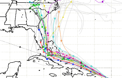
South Florida Water Management District A September 7 spaghetti model.
As new forecast models show a shift to the east for Hurricane Irma, the governor of South Carolina has now declared a statement of emergency for that state.
Hurricane Irma is an extremely dangerous storm reaching 185 mph wind speeds and remaining a Category 5. Its path has been unpredictable for days, although most forecasting models show it tracking toward Florida. The concern for South Carolina is what it does after that point, and the latest modeling shows that the storm could track north and then into the state.
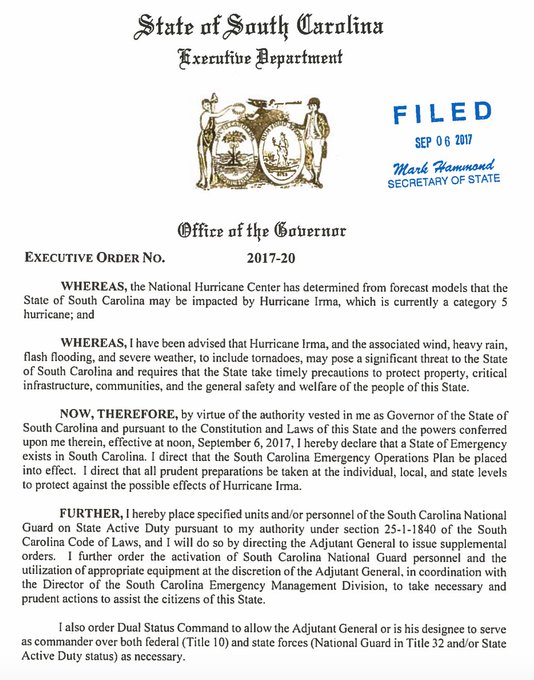
The governor on September 6 declared a state of emergency for South Carolina, saying the hurricane now “may pose a significant threat to the state.”
“The National Hurricane Center has determined from forecast models that the State of South Carolina may be impacted by Hurricane Irma,” the governor wrote. “I have been advised that Hurricane Irma, and the associated wind, heavy rain, flash flooding, and severe weather, to include tornadoes, may pose a significant threat to the State of South Carolina.”
The governor also ordered that “the South Carolina Emergency Operations Plan be placed into effect.” He also ordered the activation of South Carolina National Guard at the the discretion of officials. Read the governor’s full September 6 statement here:
JUST IN: @henrymcmaster has declared a state of emergency in South Carolina ahead of #HurricaneIrma‘s potential landfall #scpol

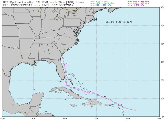
The threat to South Carolina all depends on which model you use, but some of the latest ones are not good news for the Carolinas. The latest GFS models show Hurricane Irma heading to the east of Florida, rushing up the Eastern Seaboard, perhaps making landfall somewhere in the Carolinas. Read more about those models here. Spaghetti models – which literally look like noodles on a map – are looking ominous for the state, as they also are showing an eastward and northern track for the hurricane, imperiling South Carolina. See some of the September 6 spaghetti plots here.
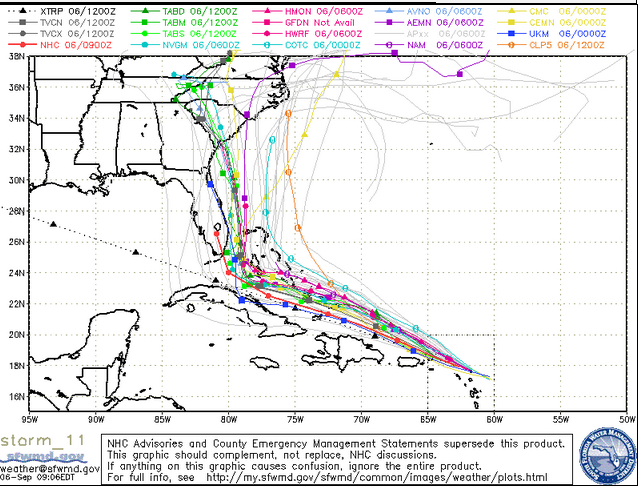
South Florida Water Management DistrictSpaghetti model from September 6.
Currently, the storm’s path shows it will likely strike southern Florida and the Florida Keys and the National Weather Service reports that there is an increasing chance of this; what it will do after turning northward is not yet entirely clear. The Post Courier reported on September 5, “The storm could possibly cross Florida, reemerge in the Atlantic and head up toward a landfall in the Carolinas. A direct track to South Carolina could not yet be ruled out.”
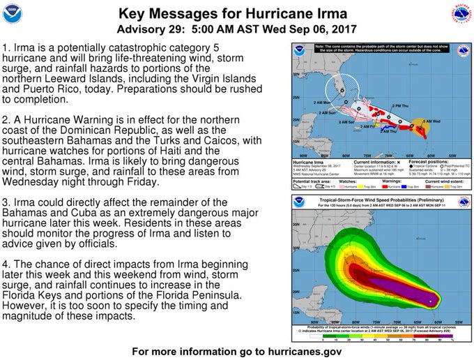
5 AM AST forecast and key messages for Hurricane #Irma. Go to t.co/tW4KeGdBFb for the latest forecast.
Here’s the latest Irma cone from the National Weather Service on September 6:
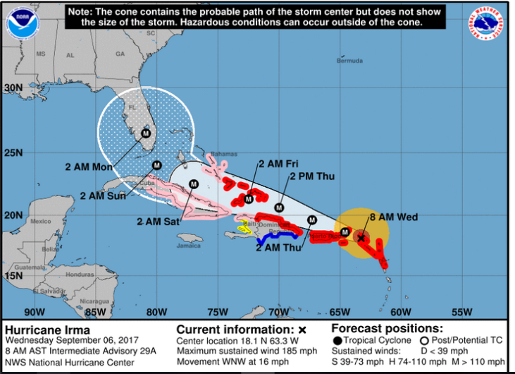
National Weather ServiceThe September 6 morning forecast path for Hurricane Irma.
The September 6 hazardous weather outlook for Charleston reads:
“Tropical Weather: Impacts associated with Hurricane Irma are expected this weekend into early next week. It is still too early to pin down the magnitude of the impacts as there remains uncertainty with the track the hurricane will take and how strong it will be as it approaches the Southeast United States. Everyone across Southeast South Carolina and Southeast Georgia, especially those in hurricane prone areas, should have a hurricane plan in place and continue to monitor the latest forecasts from the National Hurricane Center.
Rip Currents: Long period swells generated by approaching Hurricane Irma will persist into early next week. These swells will enhance the risk for powerful and dangerous rip currents at area beaches into early next week as Irma draws closer to the region.”Tropical Weather: There is an increasing risk for impacts associated with Hurricane Irma over the weekend into early next week. It is still too early to pin down exactly how Irma will impact the region as there remains uncertainty with the track the hurricane will take and how strong it will be as it approaches the Southeast United States. Everyone across Southeast South Carolina and Southeast Georgia, especially those in hurricane prone areas, should have hurricane plan in place and continue to monitor the latest forecasts from the National Hurricane Center.”
Big shift east between the 12z and 18z runs of the GFS. Seems like an outlier but we’ll see if this becomes a trend. #Irma

According to the NWS Charleston Office, “The NWS Charleston, SC Forecast Office is working closely with our partners to ensure that our area is prepared for any potential impacts Irma will bring locally. We are working with the National Hurricane Center, as well as other national, regional, and local NWS forecast offices to ensure that the best possible forecast is created. We are working with state and local officials to deliver this forecast to assist with decision making leading up to the storm. We are working with local and national broadcast meteorologists to ensure that a consistent message and accurate forecast is delivered to the public to assist with your decision making.”
The office added: “While significant uncertainty remains with the track of Irma after it passes South Florida, there are a number of things you should be taking care of NOW while the local impacts from the storm continue to the ironed out:
* Know your evacuation zone and route. If an evacuation is ordered for your area, get out early.
* Have a plan for protecting yourself and your loved ones regardless of if an evacuation is or is not ordered. Consider your pets and your home in this plan.
* Have a disaster supply kit including food, water, flashlights and batteries, first aid supplies, etc.
* Stay tuned to RELIABLE sources of information including weather.gov/chs, hurricanes.gov, reputable local and national broadcast media, and local and state officials. Do not trust everything you see on social media!”
The National Weather Service’s office that serves Atlanta released this video update on September 6 and said that two of the September 6 models show the hurricane making landfall in South Carolina, whereas others show it heading out to sea.
You can read the weather forecast for Myrtle Beach here. (Savannah, Georgia’s weather is also charted through the Charleston office.)
See the updated radar for Charleston here. See the hourly forecast here. See infrared satellite maps here.
According to The National Weather Service, “#Irma is the strongest #hurricane in the Atlantic basin outside of the Caribbean Sea & Gulf of Mexico in NHC records.”
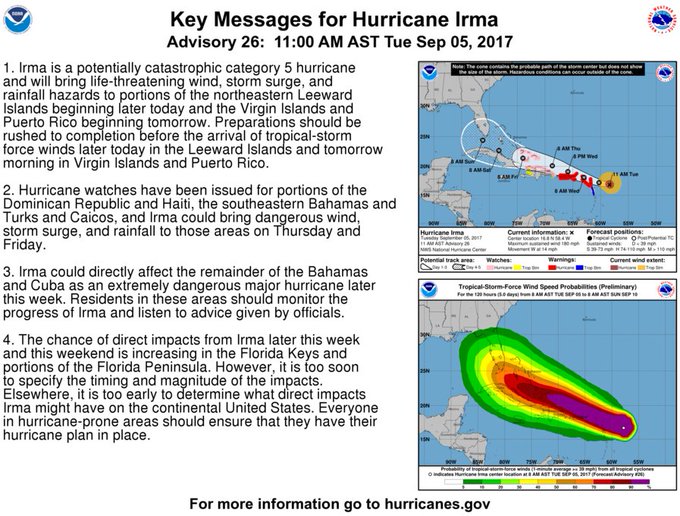
#Irma key messages for Advisory 26. #Hurricane preparations should be rushed to completion in the NE Caribbean. t.co/tW4KeGdBFb
The Post and Courier has put together a local hurricane guide for South Carolina.
There are currently no hurricane warnings for South Carolina.
Here’s an extended forecast for Charleston from the National Weather Service:
“Today (September 6)
A chance of showers and thunderstorms. Mostly cloudy, with a high near 85. Southwest wind 10 to 16 mph. Chance of precipitation is 40%.
Tonight
Showers and thunderstorms likely, mainly before 10pm. Cloudy, with a low around 72. Southwest wind 8 to 13 mph becoming northwest after midnight. Chance of precipitation is 60%. New rainfall amounts between a tenth and quarter of an inch, except higher amounts possible in thunderstorms.
Thursday
Mostly cloudy, then gradually becoming sunny, with a high near 83. North wind around 9 mph.
Thursday Night
Mostly clear, with a low around 65. Northeast wind around 7 mph.
Friday
Sunny, with a high near 83. Northeast wind 8 to 13 mph.
Friday Night
Mostly clear, with a low around 67.
Saturday
Mostly sunny, with a high near 82.
Saturday Night
A chance of showers after 9pm. Mostly cloudy, with a low around 68. Chance of precipitation is 30%.
Sunday
A chance of showers. Mostly cloudy, with a high near 77. Breezy. Chance of precipitation is 40%.
Sunday Night
A chance of showers. Cloudy, with a low around 70. Breezy. Chance of precipitation is 50%.
Monday
Showers likely. Cloudy, with a high near 80. Windy. Chance of precipitation is 70%.
Monday Night
Showers likely. Cloudy, with a low around 71. Windy. Chance of precipitation is 70%.
Tuesday
Showers likely. Mostly cloudy, with a high near 82. Breezy. Chance of precipitation is 60%.”