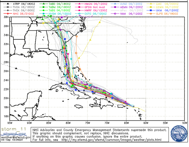
South Florida Water Management District A September 6 evening spaghetti model.
They look like strands of spaghetti tossed on a map, but Hurricane Irma “spaghetti models” are causing a lot of concern in the Carolinas especially.
That’s because many of the September 6 spaghetti models, including those in the evening, show Irma shifting to the east and making landfall in the Carolinas. Some of them also show Georgia in peril, and although Florida is still in the projected hurricane forecast path, some of the models show that if the storm continues to shift eastward, Florida might be spared the worst brunt of it.
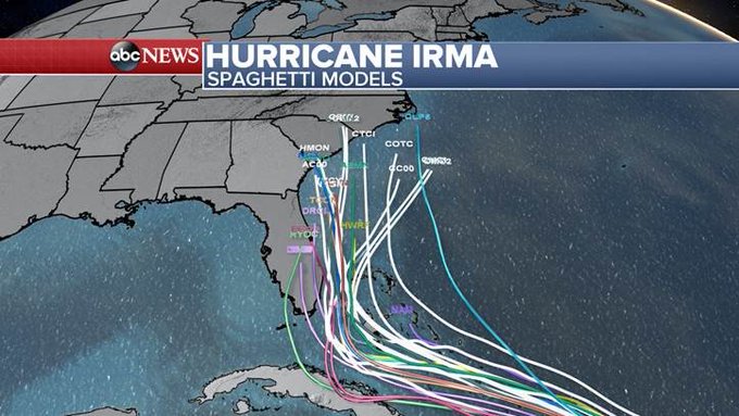
Here’s the latest spaghetti models. Trending east. Georgia, Carolina Coast need to be on high alert. (As always this could change)
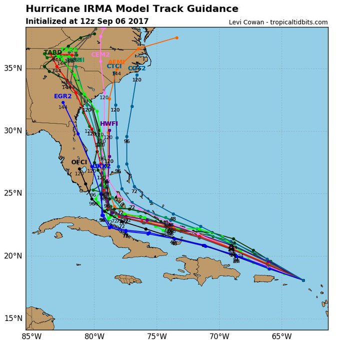
An important caveat on spaghetti models; they’re just projections. The storm remains unpredictable. Take caution and prepare. However, taken together they do tend to show the thrust of the projections. They’re all pretty much showing the same thing right now: The shift to the east, the imperiling of Georgia and the Carolinas in addition to Florida. The South Carolina governor has taken heed and declared a state of emergency, following on the heels of Florida.
The South Florida Water Management District has an updated Hurricane Irma spaghetti model page. Here’s what it showed on the evening of September 6: A definite eastward turn with South Carolina and Georgia in peril as well as Florida.
A spaghetti model of the Hurricane Irma path for September 6 in the evening.
Check out the shift in the storm since the morning spaghetti model:
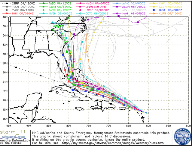
South Florida Water Management DistrictSpaghetti model from the morning of September 6.
Cyclocane has a page of updated spaghetti models for Hurricane Irma showing a similar track. You can see them here.
See a slideshow of recent spaghetti models for Irma.
The National Center for Atmospheric Research (NCAR) also has Hurricane Irma spaghetti models.
See some of the latest for September 6 here and here.
Some people point out that caution should be used when relying on spaghetti models; in contrast, the other cone approach contains a zone of uncertainty, whereas spaghetti models don’t always convey how unpredictable the storm can be in reality.
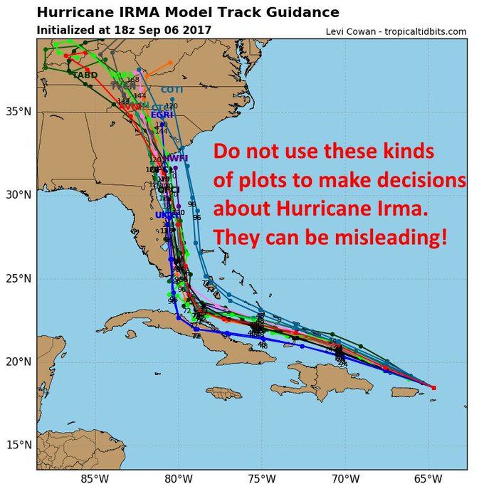
*IMPORTANT*: Do not interpret “spaghetti” plots verbatim. They do not convey the forecast uncertainty for #Irma. Listen to the NHC forecast.
What are spaghetti models? “Spaghetti models (also called spaghetti plots) is the nickname given to the computer models that show potential tropical cyclone paths. When shown together, the individual model tracks can somewhat resemble strands of spaghetti,” reports Cyclocane.
Hurricane Irma ‘spaghetti models’ show many potential paths for the storm — here’s what they mean t.co/WyROKd76ZE

Explained The Washington Post: “Usually, each ‘strand of spaghetti’ is not representative of a unique model. Instead, the entire bowl of noodles is data churned out by the same weather model. Each noodle is called an ensemble member. When a weather model produces a forecast, it has to initialize the data, taking in current conditions to get an idea of what the atmosphere is already doing on a three-dimensional grid.” The Post notes that the models require estimates that are not always accurate.
Spaghetti models are just one type of forecasting approach being used in Irma. There’s also the forecast cone using by the National Oceanic & Atmospheric Administration (NOAA). The 5 p.m. map for September 6 now shows the cone extending into Georgia and South Carolina. It doesn’t tell that different of a story than the spaghetti models, though, when you look at it.
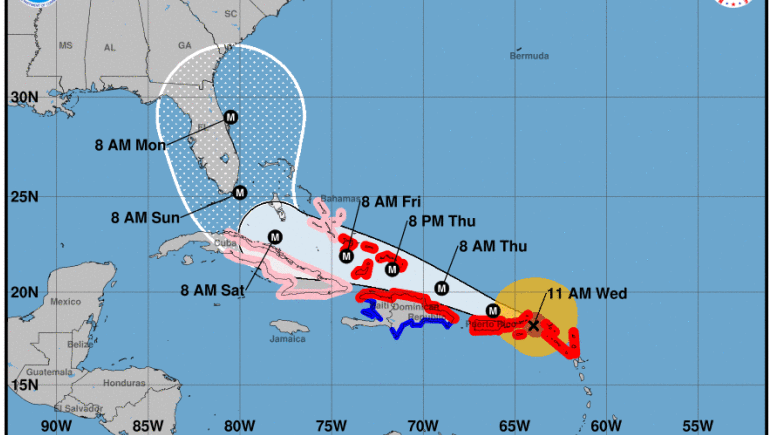
National Hurricane CenterHurricane Irma forecast cone on September 6.
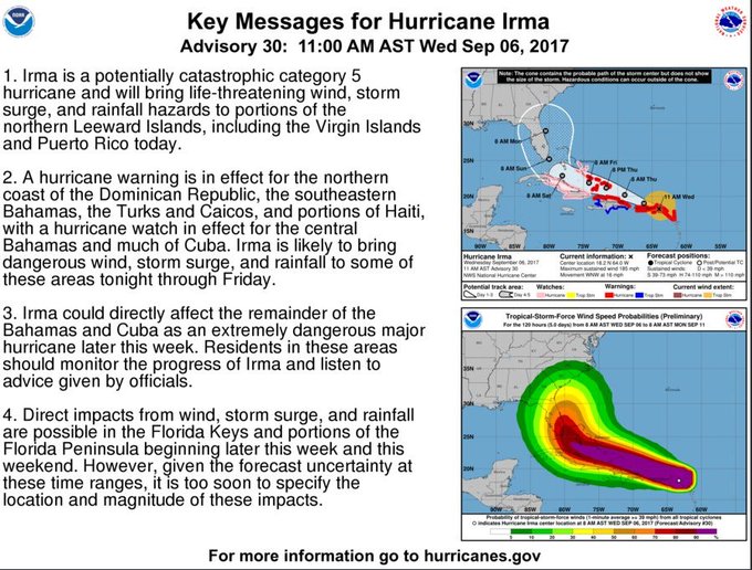
In its evening advisory on Hurricane Irma, the National Weather Service wrote: “At 500 PM AST (2100 UTC), the eye of Hurricane Irma was olocated near latitude 18.8 North, longitude 65.4 West. Irma is moving toward the west-northwest near 16 mph (26 km/h), and this general motion is expected to continue for the next couple of days. On the
forecast track, the extremely dangerous core of Irma will pass just north of Puerto Rico tonight, pass near or just north of the coast of Hispaniola Thursday, and be near the Turks and Caicos and southeastern Bahamas by Thursday evening.”

The critical question is what the storm does after that: Does it continue on a westward track over the Gulf or spin north into Florida and, if so, does it head up eastern Florida, central, or the western coast? Does it spin up into the Carolinas or Georgia? These are all unknowns, and models, including spaghetti models, can simply provide an educated guess.
“Maximum sustained winds are near 185 mph (295 km/h) with higher gusts,” NWS wrote. “Irma is a category 5 hurricane on the Saffir-Simpson Hurricane Wind Scale. Some fluctuations in intensity are likely during the next day or two, but Irma is forecast to remain a powerful category 4 or 5 hurricane during the next couple of days.”
Here are more recent spaghetti models for Irma:
Proof that Hurricane Irma is the Flying Spaghetti Monster
#spaghetti #flyingspagettimonster #monster

The latest spaghetti models for Hurricane #Irma … plus story updates here: t.co/4ksmiHC4Rd

Latest #Irma spaghetti models
Spaghetti models put Hurricane Irma near Florida this weekend t.co/BhZPLw8toG

Spaghetti is looking more favorable for us but much worse for Bahamas. Hard to be relieved in a miss when someone else takes the hit. #Irma

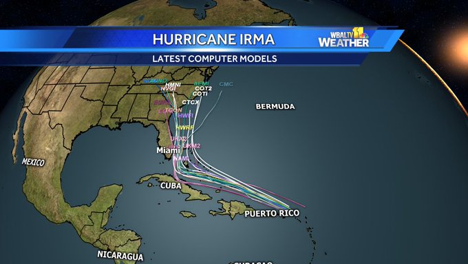
Spaghetti models starting to show #IrmaHurricane #Irma shifting more East. Florida still in danger zone, East Coast may be in play. #wbal