The latest track of Hurricane Irma shows it heading up through Florida’s spine an impacting more people than first originally thought.
Hurricane Irma has its eye set on much of the state of Florida.
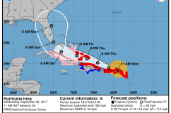
The latest projection model, as of 11 a.m. Eastern on Friday, shows Irma making landfall in the southern part of Florida early Sunday morning and heading up through the center of the state on its way to Georgia and Alabama.
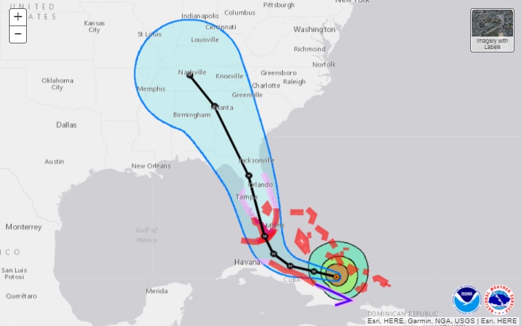
Take a look at a more detailed view of the latest track below:
11 am update on Hurricane Irma. Watches and warnings remain to our south for now. It’s time to finalize preparations for impacts from #Irma.
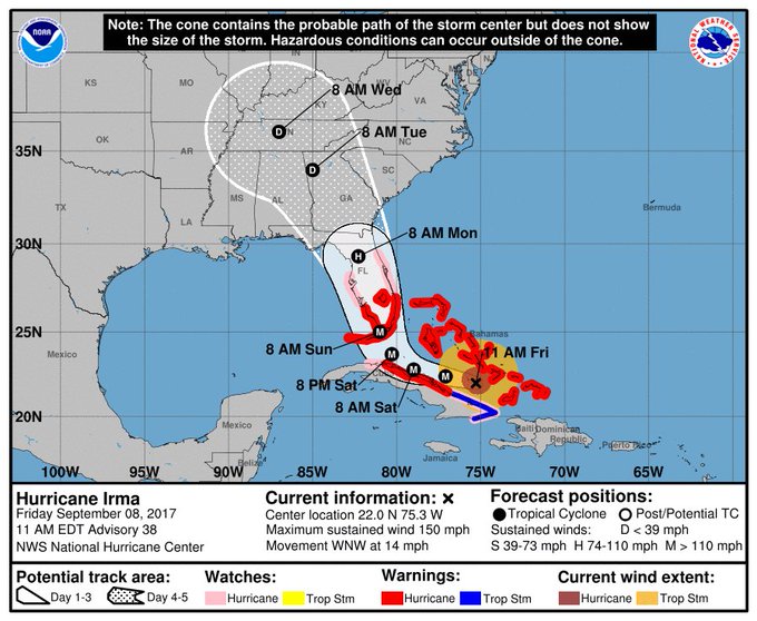
The update is discouraging news for those residing in the northern Florida and Tallahassee areas. Currently, Irma is a Category 4 hurricane that has winds registering over 150 mph. Meteorologists are predicting that Irma will be felt in northern Florida some time Monday, and those in its path are encouraged to monitor it as it makes landfall.
If the current model continues to hold, Tallahassee will feel some of the impact of Irma starting Sunday evening, but it should dissipate as it moves through the state.
National Weather Service Don Harrigan told The Tallahassee Democrat said Tallahassee should get winds registering around 70 mph in addition to rainfall measuring around 2-4 inches. Harrigan added that while the weather will be treacherous, people should expect something between what the area felt during Hurricanes Matthew and Hermine.
“I don’t know if we’re expecting anything as widespread and damaging as Hermine was, but there will be pockets around the region that could have similar type damage,” Harrigan said to the newspaper. “With this track, we would expect to see at least some power outages across the region and trees down.”
The current track shows Irma weakening to a Category 2 storm by the time it reaches the Orlando area Monday, and it should turn into a tropical storm by the time it hits Georgia and Tennessee.
On Monday, Florida Gov. Rick Scott declared a statewide state of emergency, giving officials the appropriate time to prep for the storm. Residents of the Sunshine State have been encouraged since then to review emergency plans and potential evacuation plans.
Here’s the latest weather forecast for Tallahassee through Irma, according to AccuWeather:
Friday night: Clear with a low of 67 degrees and 6 mph NE winds.
Saturday: Sunny with periods of clouds. High of 84 degrees with 9 mph NNE winds.
Saturday night: Increasing clouds with a low of 67 degrees and 9 mph NNE winds.
Sunday: Mostly cloudy and cooler with a high of 74 degrees. Becoming breezy during the afternoon with showers and thunderstorms likely. Winds at 13 mph NNE with gusts reaching 34 mph.
Sunday night: Heavy rain and strong damaging winds from Irma. Low of 63 degrees with 40 mph N winds and gusts reaching 74 mph.
Monday: High of 72 degrees with some wind and rain from IRma. Flooding and isolated tornadoes possible with winds at 30 mph NNW and gusts reaching 56 mph.
Monday night: Low of 60 degrees with some rain from Tropical Storm Irma, mainly clear late. Winds at 12 mph W with gusts around 36 mph.
For the latest updates on Irma, click here.