National Hurricane Center
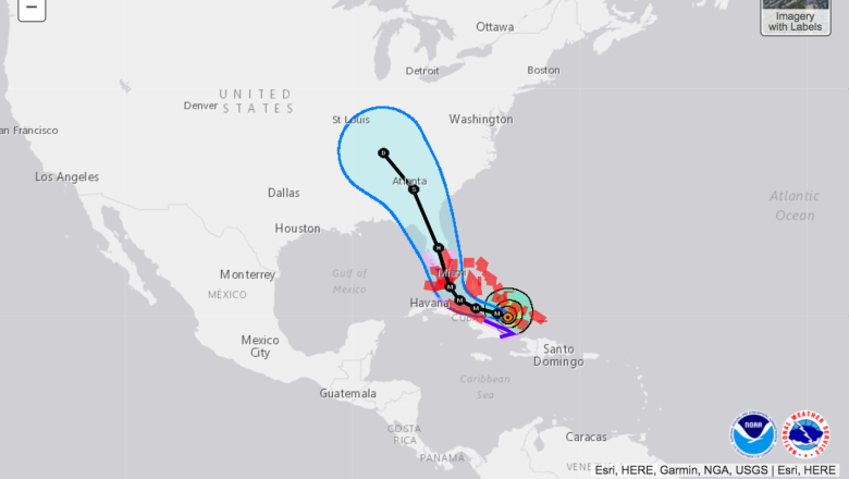
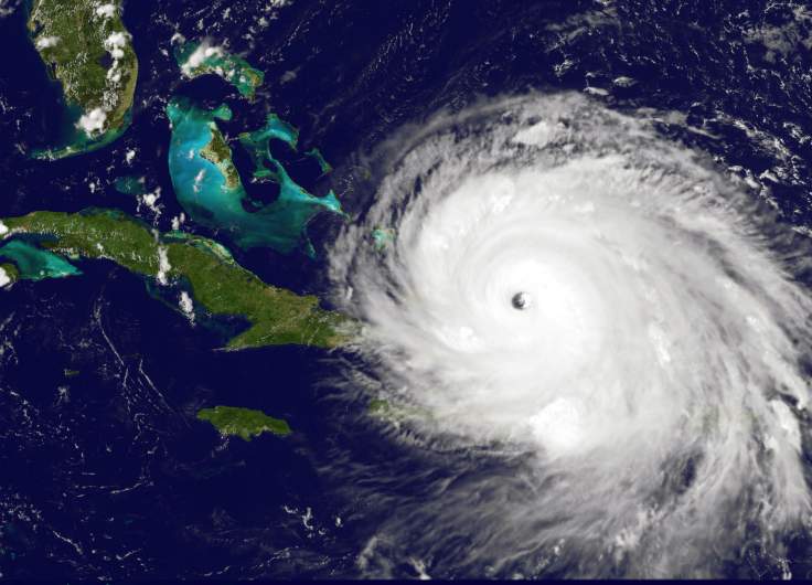
The city of Tampa, Florida, is preparing for Hurricane Irma after both the GFS and the European models have shifted to the west, eyeing the Bay.
Hurricane and storm surge warning were issued for Tampa, and landfall is projected to come not far away, but a bit to the south, perhaps in Naples or Port Charlotte.
“Hurricane Irma is a dangerous hurricane that will produce storm surge up to 15 feet in southwest Florida, very heavy rain, inland flooding and short lived tornadoes. 10 to 20 inches of rain will fall throughout the state with isolated locations approaching 25 inches. Numerous Hurricane and Storm Surge Warnings are in effect,” NWS reported on the evening of September 6.
Here is what you need to know:
1. Hurricane Conditions Are Now ‘Expected’ in Tampa
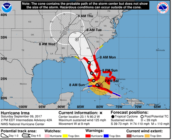
Hurricane Irma is making her way to Florida and will be impacting the southwestern part of the state after the Keys. Once she hits land, she is expected to slow down — and she will weaken.
Irma will make her way into Tampa on Sunday. The worst of the storm is expected in the overnight hours (from Sunday into Monday).
The September 9 forecast from National Weather Service reports that Tampa is projected to see possible hurricane conditions on Sunday with hurricane conditions “expected” on Sunday night and possible on Monday as well.
Below is a list of hurricane shelters in Hillsborough County.
Middleton High School, 4801 N 22nd Street, Tampa
Simmons Career Center, 1202 W Grant Street, Plant City
Shields Middle School, 15732 Beth Shields Ways, Ruskin (Pet-Friendly)
Pizzo Elementary School, 11701 Bull Run, Tampa
Cypress Creek Elementary School, 400 19th Ave NE, Ruskin
Hammond Elementary School, 8008 N Mobley Road, Odessa
Sessums Elementary School, 11525 Ramble Creek Drive, Riverview
Bartels Middle School, 9020 Imperial Oak Blvd, Tampa (Pet-Friendly)
Brandon High School, 1101 Victoria Street, Brandon
Smith, Sgt. Paul Middle School, 14303 Citrus Pointe Drive, Tampa (Pet-Friendly)
Burnett Middle School, 1010 N Kingsway Road, Seffner (Pet-Friendly)
Valrico Elementary School, 609 South Miller Road, Valrico
Summerfield Crossings Elementary School, 11050 Fairway Meadow Road, Valrico
Greco Middle School, 6925 East Fowler Ave, Temple Terrace
You can see evacuation information here.
2. Tampa Is Facing a Flash Flood Threat From Irma
NWSHurricane Irma Saturday afternoon forecast.
On Saturday evening, the National Weather Service reported that Tampa is subject to a “Flash Flood Watch.”
LATEST LOCAL FORECAST: Flash Flood Watch is in effect (as of the evening of September 9)
Peak Rainfall Amounts:
Additional 6-10 inches, with locally
higher amounts
Localized flooding is possible, but local meteorologists have been clear about this storm being nothing like Hurricane Harvey, which dumped well over a foot of rain in Houston late last month. Harvey stalled over Houston, continuously dumping water on the city, which won’t be happening in Tampa; Irma is expected to move straight through without stopping.
3. How Bad Will the Wind Be?
Tampa is set to experience hurricane-force winds that will begin moving into the area on Sunday morning. Since the eye of the storm is set to be closer to Lakeland as it moves through the state, Tampa will be on the east side which means that wind speeds will be lower than on the west side (also known as the “dirty side”) of Irma.
LATEST LOCAL FORECAST: Equivalent Cat 2 Hurricane force wind (as of September 9)
– Peak Wind Forecast: 85-105 mph
with gusts to 130 mph
– Window for Tropical Storm force
winds: Sunday afternoon until
Monday afternoon
– Window for Hurricane force
winds: Sunday evening until Monday
afternoon
4. What Category Storm Will Irma Be When She Reaches Tampa?
Irma is still a very powerful storm, but her wind speeds have lessened over the past 24 hours or so. She is expected to slow down slightly before she impacts southern Florida. She is expected to make landfall as a Category 4, but will weaken to a Category 2 before she reaches the Tampa Bay area.
A Category 2 hurricane has winds from 96 to 110 mph closest to its center, according to the Saffir-Simpson scale. It brings “extremely dangerous winds will cause extensive damage.”
“Well-constructed frame homes could sustain major roof and siding damage. Many shallowly rooted trees will be snapped or uprooted and block numerous roads. Near-total power loss is expected with outages that could last from several days to weeks.”
5. Wide Power Outages Are Expected
A Category 2 hurricane is not nearly as bad as a Category 5, but it’s still going to bring nasty weather to Tampa.
“You’re going to have some trees down. You might have some pool cages damaged. Unless there’s a drastic change here, this is not going to be a devastating hurricane for the Bay area. With the [current tracks], we’re going to have 60 maybe 65 [mph winds] — we’ve gone through that before folks. Our typical late day storms go 60. A severe thunderstorm warning needs 60 mph winds,” Phillips said.
You can watch Phillips’ full take on Tampa and Hurricane Irma in the video below.