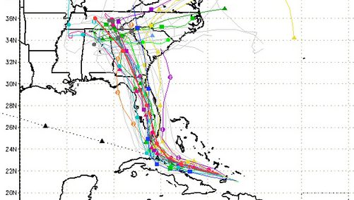
South Florida Waste Management District Spaghetti model for September 8.
Hurricane Irma is hours away from hitting the Key West, Florida area and residents and tourists have been urged by officials to take proper precautions and evacuate before it makes landfall.
The latest weather forecast from the National Weather Service as of 12:15 p.m. Eastern on Friday says residents in Monroe County should prepare for extreme winds in excess of 110 mph, a high probability of a storm surge affecting those living 6 feet above ground and the potential for tornadoes.
Latest Path & Evacuation Information
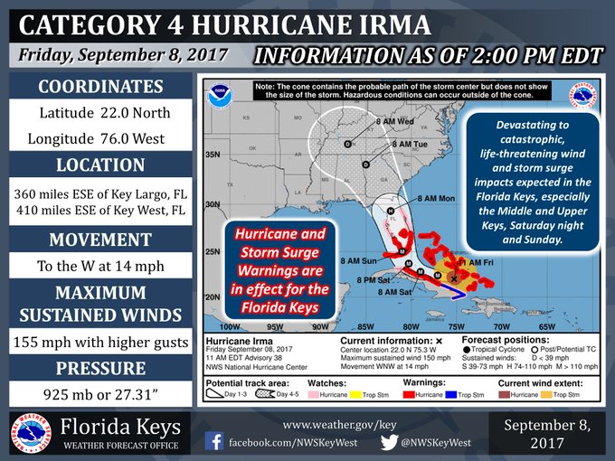
The exact path of Irma continues to take form, and it’s expected to hit near the Florida Keys area beginning around 8 p.m. on Saturday.
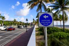
As a result, mandatory evacuations have been put into place for the Florida Keys for both residents and visitors. Those started Wednesday, and hurricane and storm surge warnings have been put into effect for all of the Florida keys, too.
“All visitors, tourists and non-residents are hereby urged to seek safe shelter in mainland Florida,” the city said in an official statement. “This evacuation order shall remain in effect until the danger has past, as determined by the Mayor, Mayor Pro Tem or Sheriff after consultation with the Director of Emergency Management.”
The NWS also issued major key points for Irma and the effect it will have on the area, saying there are multiple options for those evacuating if transportation is not available. That includes a number of buses that have been moving people to land and to shelters.
Key West Transit has a free hurricane evacuation service Friday. Buses will be clearly marked “hurricane evacuation” on the destination boards. They are to circulate throughout Key West, picking up riders at regular bus stops. Riders will be transferred to the transit center on Stock Island and then buses will proceed to the hurricane shelter at Florida International University. Evacuees are asked to go to the nearest bus stop, or the Key West Transit Center on College Road.
Critical evacuation information from @monroecounty (Monroe County Emergency Management) regarding category 4 Hurricane #Irma. #FLwx #FLKeys

Animals are also being evacuated from the area.
For additional information on evacuations from Monroe County, click here.
Weather Forecast
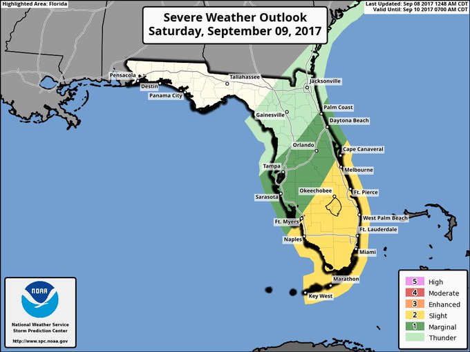
Severe Thunderstorms and mostly Tornadoes are possible from Palm Coast down to Key West, slight risk has a higher tornado threat.
The weather forecast for the weekend, according to AccuWeather, is as follows.
Friday night: Mostly cloudy and breezy with a couple of showers and a low of 81 degrees. Winds from the NNE at 16 mph with gusts touching 28 mph.
Saturday: Very windy and cloudy with a couple of thunderstorms and a high of 88 degrees. Winds from the NNE at 32 mph with gusts reaching 64 mph.
Saturday night: Torrential rain and strong winds from Irma that will lead to flooding. Low of 80 degrees with winds from the N at 58 mph and gusts reaching 89 mph.
Sunday: Irma brings more torrential rain and strong winds. Heavy tropical rainfall will lead to flooding. A high of 86 degrees with winds from the WNW at 59 mph and gusts reaching 93 mph.
Sunday night: Strong winds and rainfall that will be damaging to the area. A low of 81 degrees with winds coming from the WSW at 44 mph and gusts touching 78 mph.
Monday: Invertals of clouds and sun with a shower or two and a high of 89 degrees. Winds from the WSW at 17 mph with gusts at 34 mph.
Monday night: An evening shower and a low of 81 degrees. Winds from the WSW at 9 mph with gusts reaching 15 mph.
Airport Closures
Due to Irma, the Key West International Airport closed Wednesday. All commercial flights at the airport were canceled from Thursday morning “until further notice,” the airport’s website said.
However, general aviation is continuing at the airport until conditions become too unsafe to operate. The Florida Keys Marathon International Airport is also remaining open for general aviation until it becomes too unsafe to fly.
For more information on Irma, click here.