National Hurricane Center
With the attention focused on the western part of Florida Saturday, how concerned should people in Orlando, Florida be about Hurricane Irma?
Although the hurricane is now expected to make landfall in southwestern Florida, perhaps between Sarasota and Naples, that doesn’t mean that Orlando and other areas of the state are out of the woods. The massive size of the hurricane means that even areas outside of the eye could see a severe impact. There was a hurricane warning in Orlando on September 9.
From the National Weather Service:
Wind Threat:
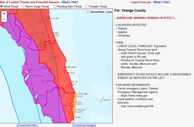
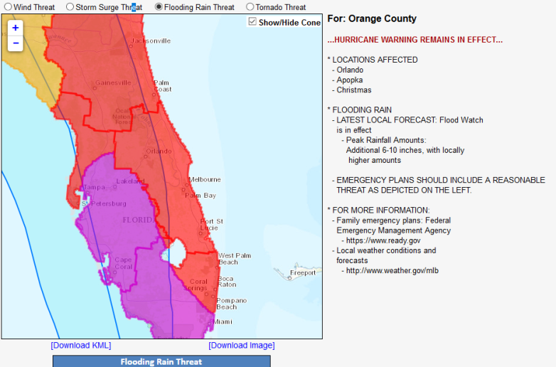
You can use the interactive map to change the map for other threats, including storm surge, tornadoes, and flooding.
Flooding threat:
The weather forecast for Orlando on September 8 reported that hurricane conditions were possible Sunday, were “expected” on Sunday night, and were possible on Monday.
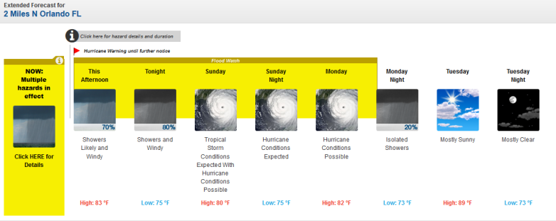
Orlando forecast at 5 p.m. Saturday.
See updated Orlando radar here. Track the path of Irma on satellite radar here.
Orlando was well within the forecast cone despite the modeling projecting the storm will strike on the western coast first.
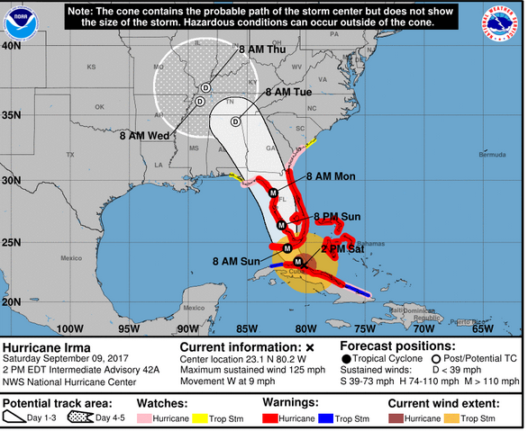
Hurricane Irma Saturday afternoon forecast.
Here’s a spaghetti model showing the storm’s westward shift, though:
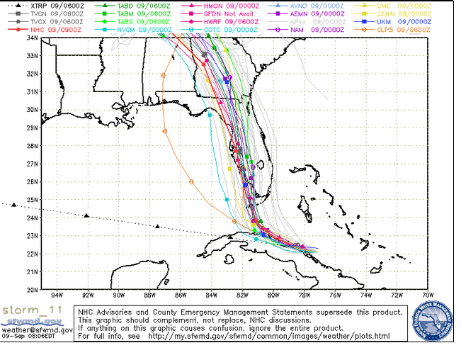
South Florida Waste Management DistrictSaturday morning spaghetti model.
The local hurricane outlook for Orlando read on September 9:
“Dangerous Hurricane Irma moving west northwest near the north coast of Cuba is forecast to approach the Florida Keys as a Category 4 hurricane Sunday morning. Irma is forecast to move over the Western Florida peninsula Sunday through early Monday morning as a strong hurricane. The large hurricane wind field of Irma will produce far-reaching effects regardless of where the exact center moves. Hurricane force wind gusts will remain a significant concern and will have the potential for widespread damage along and to the east of Irma`s track.
The potential for flooding rain associated with repeated squalls, will increase across east central Florida early on Sunday and into Monday. Although Irma will be moving steadily forward, it will produce 8 to 12 inches of rain with locally higher amounts up to 16 inches. Squalls will also bring an increasing chance for the development of tornadoes
as Irma nears the region on Sunday. Wind driven water inundation will also be possible in areas adjacent to larger inland lakes, such as Lakes Okeechobee, Kissimmee, and Lake George, as well as the Intracoastal Waterway.
Efforts to protect life and property should be rushed to completion! From around Lake Okeechobee to the Treasure coast counties, every effort should be taken to bring hurricane preparations to completion by this afternoon, before weather conditions further deteriorate. Areas farther north from greater Kissimmee-Saint Cloud, Orlando, Sanford, and Lake County eastward to the Space Coast and the greater Daytona Beach area should have preparations completed by this evening.
Surf conditions will remain hazardous as large swells bring high surf and increasingly strong rip currents. Moderate to significant beach erosion will ensue, and become progressively worse throughout the remainder of the weekend and into Monday.”
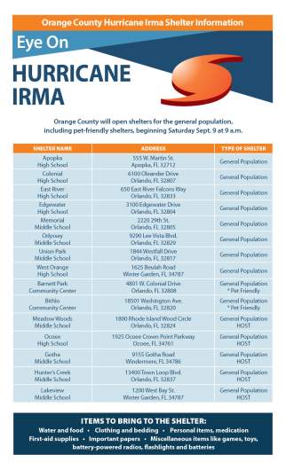
These are the Orange County shelters that opened on Saturday morning: