National Hurricane Center
Hurricane Maria is being closely watched because her path, at least in the early stages, resembles that of Irma. However, Maria’s path, in some of the latest trackers and models, shows her veering to the north and missing the U.S. Maria is expected to become a hurricane by the end of Sunday.
It’s too soon to tell for sure, however, which direction the weather system will take. That has people following the latest storm closely.
What are some of the ways that you can track Tropical Storm Maria/Hurricane Maria in real time? Here are some of the best Maria trackers that you can use to follow the storm’s path:
National Hurricane Center & National Weather Service
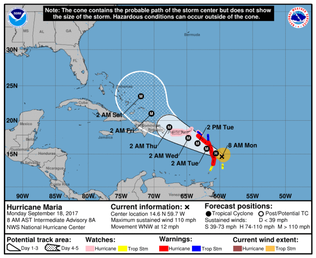
NHC/NOAAHurricane Maria forecast at 8 a.m. from the National Hurricane Center.
These are the sites that the news media most heavily rely on. Here is the Center’s page for Tropical Storm Maria. You can track many different projections on the page, ranging from wind speeds to rainfall. See the storm’s forecast advisory here.
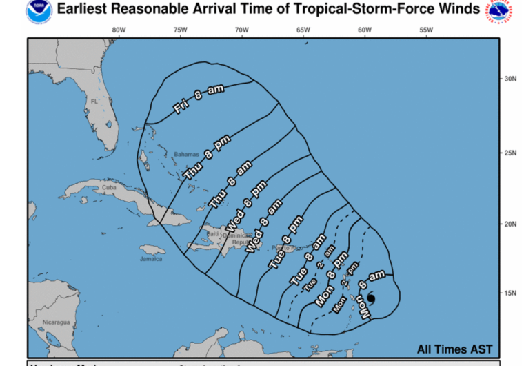
NHCWind arrival times.
You can also search for any community in the U.S. in the National Weather Service page and get updated real-time maps for the weather in the area. For example, here’s Tampa. Just enter city, state or zip code in the top left box.
The Weather Channel
The Weather Channel has an updated tracker for Maria.
NOAA
The National Oceanic and Atmospheric Administration has an updated map that tracks the paths of all hurricanes and tropical storms for 2017, including Tropical Storm Maria. The map currently has Jose and Lee on it also. You can even map the historical tracks of all hurricanes here.
See colorized infrared images of the storm that you can update with your cursor. Follow storm systems over the continental U.S. here. Track other 2017 storms here.
Cyclocane
Cyclocane has a lot of real-time maps including satellite and spaghetti models for Maria. The Cyclocane site will also give you data such as the storm’s current status.
Weather Underground
Weather Underground also offers a lot of real-time maps on Maria.
South Florida Waste Management District
This government site has a regularly updated spaghetti model of the storm’s path. See the map here.
UW-Madison & National Center for Atmospheric Research
NCAR’s Tropical Cyclone Guidance Project has a lot of real-time data and maps, including spaghetti models. See the Maria page here.
The University of Wisconsin-Madison is also doing real-time tracking. Click on the yellow symbol for Maria to see more at this page.