NWS Irma wind speeds for Saturday.
Will Hurricane Irma hit Tampa, Florida? The chances are increasingly likely, there’s a hurricane warning for Tampa, and people in Tampa should take shelter.
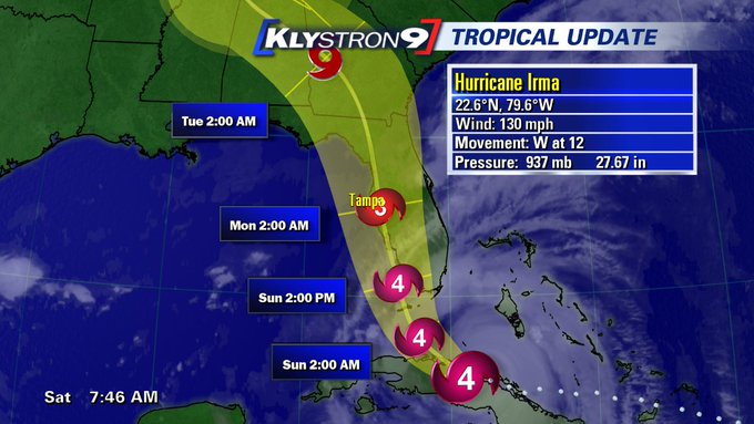
The monster hurricane continued to shift to the west on September 9, a trend that developed over the past day. That’s caused grave concern all along the western coast of the state, which, just a day before had watched as the hurricane was, then, moving eastward.
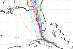
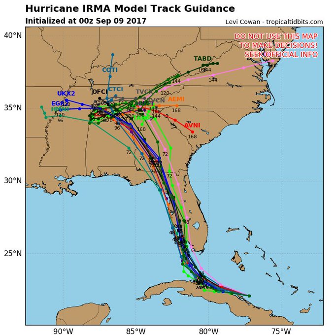
The newest run of the spaghetti models shows lots of agreement but have shifted to the west again, taking #Irma over western Florida coast.
When will it arrive? Here’s the latest wind arrival time chart from the National Hurricane Center for Saturday morning (see a list of shelters in Tampa at the end of this story):
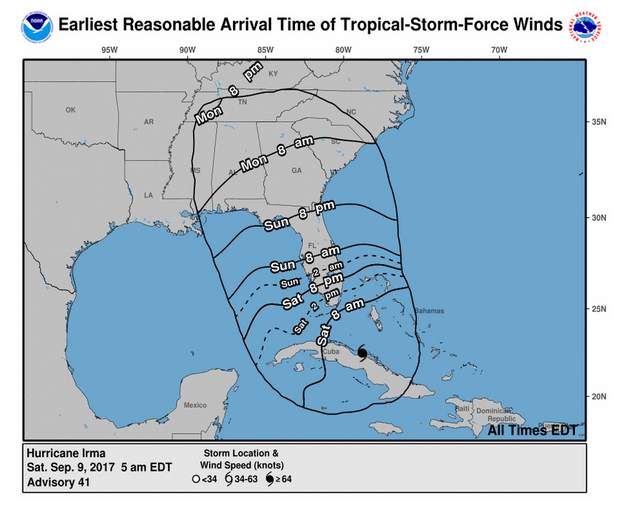
NHCWind arrival times for Irma – Saturday, September 9 projection.
See the latest Tampa radar here. Track the hurricane on infrared satellite here.
Weather.com lists the following arrival time information for Tampa/St. Petersburg:
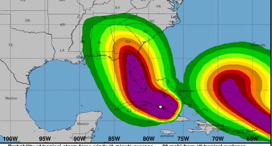
Peak storm surge forecast: 3 to 5 feet
High tide times (McKay Bay/Tampa): Monday 5:13 a.m. and 7:21 p.m.
Tropical storm-force winds begin: Sunday afternoon
Hurricane-force winds begin: Sunday night
Strongest winds, timing: Late Sunday night/early Monday morning
See the Saturday morning forecast for Tampa. You will see that it lists hurricane conditions as possible for Sunday, Sunday night and Monday.
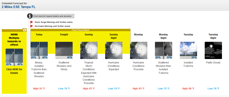
Tampa, Florida Saturday morning forecast.
Here are some of the recent forecasting models that show this western shift:
Spaghetti model:
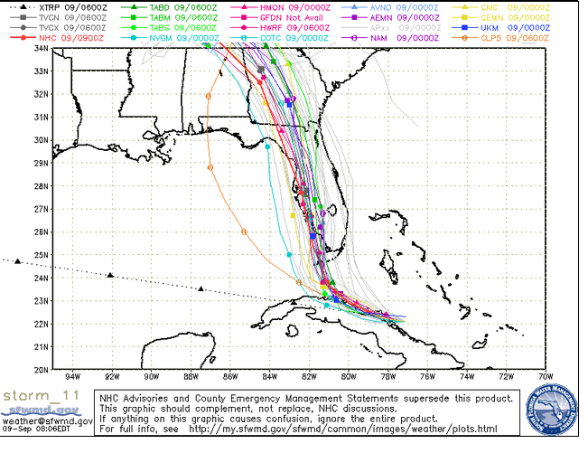
South Florida Waste Management DistrictSaturday morning spaghetti model.
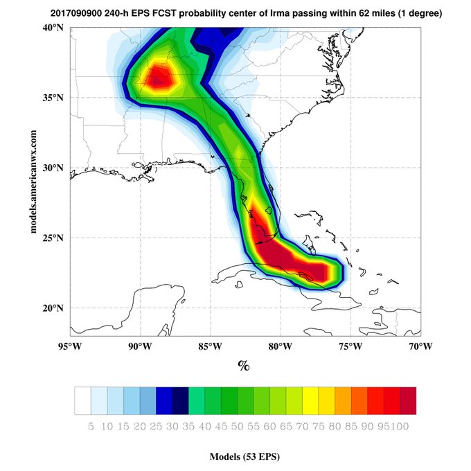
European model:
National Hurricane Center cone model:
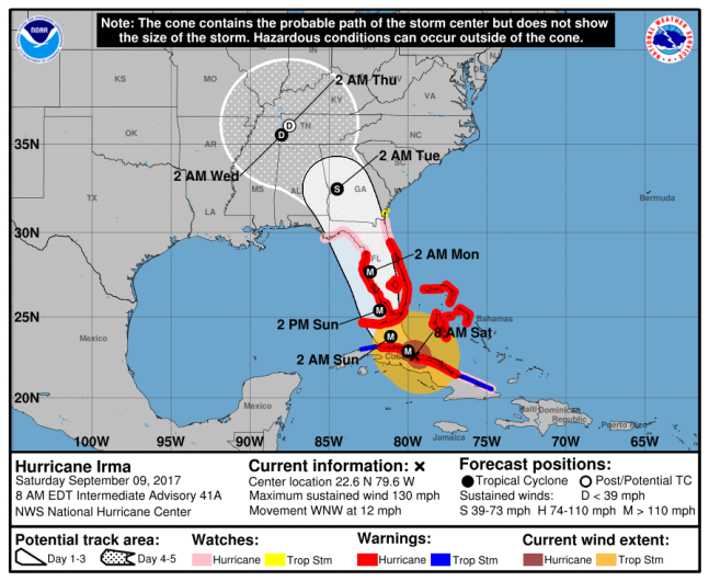
NOAA/NHCThe NOAA Hurricane Irma forecast at 8 a.m. ET.
The Hurricane Warning statement for Tampa on Saturday from the National Weather Service says, “Irma is moving toward the west-northwest near the north coast of Cuba with a turn toward the northwest expected by late today, and then a
turn toward the north-northwest expected tonight or on Sunday. On the forecast track, the center of Irma will be near the Florida Key Sunday morning, and then approach the southwest coast of Florida Sunday afternoon.”
Juli Marquez: 8 a.m. Hurricane #Irma. North coast of Cuba getting hit hard this morning. Spaghetti model plot here:
t.co/7l3G9ncUOv
Potential impacts are:
“POTENTIAL IMPACTS
—————–
* WIND:
Protect against life-threatening wind having possible devastating
impacts across West Central and Southwest Florida. Potential impacts
include:
– Structural damage to sturdy buildings, some with complete roof
and wall failures. Complete destruction of mobile homes. Damage
greatly accentuated by large airborne projectiles. Locations
may be uninhabitable for weeks or months.
– Numerous large trees snapped or uprooted along with fences and
roadway signs blown over.
– Many roads impassable from large debris, and more within urban
or heavily wooded places. Many bridges, causeways, and access
routes impassable.
– Widespread power and communications outages.
* SURGE:
Protect against life-threatening surge having possible devastating
impacts from Hernando county southward through Tampa Bay and all of
Southwest Florida. Potential impacts in this area include:
– Widespread deep inundation, with storm surge flooding greatly
accentuated by powerful battering waves. Structural damage to
buildings, with many washing away. Damage greatly compounded
from considerable floating debris. Locations may be
uninhabitable for an extended period.
– Near-shore escape routes and secondary roads washed out or
severely flooded. Flood control systems and barriers may become
stressed.
– Extreme beach erosion. New shoreline cuts possible.
– Massive damage to marinas, docks, boardwalks, and piers.
Numerous small craft broken away from moorings with many lifted
onshore and stranded.
Also, protect against life-threatening surge having possible
significant to extensive impacts across coastal portions of Levy and
Citrus counties.
* FLOODING RAIN:
Protect against life-threatening rainfall flooding having possible
extensive impacts across West Central and Southwest Florida. Potential
impacts include:
– Major rainfall flooding may prompt many evacuations and rescues.
– Rivers and tributaries may rapidly overflow their banks in
multiple places. Small streams, creeks, canals, and ditches may
become dangerous rivers. Flood control systems and barriers may
become stressed.
– Flood waters can enter many structures within multiple
communities, some structures becoming uninhabitable or washed
away. Many places where flood waters may cover escape routes.
Streets and parking lots become rivers of moving water with
underpasses submerged. Driving conditions become dangerous.
Many road and bridge closures with some weakened or washed out.
* TORNADOES:
Protect against a dangerous tornado event having possible significant
impacts across West Central and Southwest Florida. Potential impacts
include:
– The occurrence of scattered tornadoes can hinder the execution
of emergency plans during tropical events.
– Several places may experience tornado damage with a few spots
of considerable damage, power loss, and communications failures.
– Locations could realize roofs torn off frame houses, mobile
homes demolished, boxcars overturned, large trees snapped or
uprooted, vehicles tumbled, and small boats tossed about.
Dangerous projectiles can add to the toll.”
The county announced these evacuations and shelters, as of September 9:
“Hillsborough County has issued a mandatory evacuation for Evacuation Zone A starting at 8 a.m. today. The County has opened 16 shelters for residents in Evacuation Zone A, and whose homes are vulnerable to storm surge and flooding, and for manufactured homes that are susceptible to wind damage.
(Find your evacuation zone on this interactive map here.)
Below is the list of shelters now open to residents:
Middleton High School, 4801 N 22nd Street in Tampa
Simmons Career Center, 1202 W Grant Street in Plant City
Shields Middle School, 15732 Beth Shields Ways in Ruskin (Pet-Friendly) – FULL
Pizzo Elementary School, 11701 Bull Run in Tampa
Cypress Creek Elementary School, 400 19th Ave NE in Ruskin
Hammond Elementary School, 8008 N Mobley Road in Odessa
Sessums Elementary School, 11525 Ramble Creek Drive in Tampa
Bartels Middle School, 9020 Imperial Oak Blvd in Tampa (Pet-Friendly)
Brandon High School, 1101 Victoria Street in Brandon
Smith, Sgt. Paul Middle School, 14303 Citrus Pointe Drive in Tampa (Pet-Friendly)
Burnett Middle School, 1010 N Kingsway Road in Seffner (Pet-Friendly)
Valrico Elementary School, 609 South Miller Road in Valrico
Summerfield Crossings Elementary School, 11050 Fairway Meadow Road in Valrico
Greco Middle School, 6925 East Fowler Ave in Temple Terrace
Strawberry Crest High School, 4691 Gallagher Road in Dover (Special Needs Only)
SunDome at USF, 4202 E. Fowler Ave. in Tampa (Special Needs Only)
The special-needs shelters are only for residents with medical issues that require electricity assistance or cognitive issues that would not be supported in a general population shelter.
Residents bringing pets to one of the four pet-friendly shelters need to bring a sturdy carrier for each pet that allows room for the pet to stand up and move around, as well as a collar with a leash and supplies for each pet to last seven days. More information on how residents can prepare their pets can be found here – Pet Disaster Planning.
Residents can confirm evacuation zones and register for HCFL Alert, Hillsborough County’s official public notification system, at HCFLGov.net/StaySafe or by calling (813) 272-5900.”