Google Maps Portola Fire
What started out as a relatively small fire in the Beverly Hills area is now threatening homes and prompting evacuations as the fire grows. Currently at 32 acres, the fire has the potential of reaching 60 acres and is causing nearby residents to anxiously stay tuned in to the latest news about the fire’s spread. Here is what we know so far about the Portola Fire in Beverly Hills.
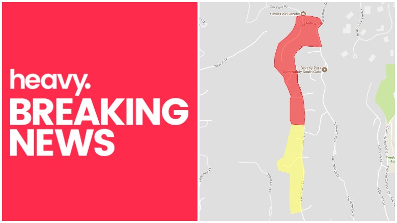
First, here is a map below of the current mandatory evacuation areas and evacuation warning areas, as provided by LAFD Ready. You may need to zoom into the map, depending on how your browser accesses it, in order to see the red and yellow areas up close.
This fire in West Los Angeles is 32 acres in size. The brush fire in Beverly Hills was originally reported at 1:57 p.m. in the 9800 block of West Portola Drive in the Beverly Crest area. Although the fire was smaller in size, its location prompted the evacuation of nearby homes. The fire was threatening homes in Portola and Yoakum Drive, NBC reported, and was burning uphill toward Benedict Canyon Drive.
Evacuations have been ordered for residents who live along Highridge Drive, down Summitridge Drive, and continuing on San Ysidro Drive to Stan Place, the LA Times reported. ABC 7 reported that mandatory evacuations were also being required on San Ysidro Drive between Milboro Place and Beeson Drive, including on Beeson and Milboro themselves. About 25 homes have been evacuated as of 4 p.m.
An evacuation center was set up at Westwood Recreation Center. People with pets were advised to take their pets with them when they evacuate. The city is providing temporary shelter for pets at the East Valley shelter in Van Nuys:
For those who are evacuating due to #PortolaFire, please take your animals with you. If you need temporary shelter for your cats, dogs & other small pets, please visit the East Valley Animal Services Center at 14409 Vanowen Street, Van Nuys, CA 91405 for assistance.
Other residents in the area need to stay tuned to local news to see if the evacuation orders are expanded. Evacuation warnings were issued for residents on San Circle down San Ysidro Drive to Peavine Drive, the LA Times reported.
This fire is also being referred to as the Benedict Canyon fire, as officials have advised residents in areas of Benedict Canyon Drive from Portola to Yoakum to consider evacuating, ABC 7 reported. The region is an affluent area which includes the $1 billion Vineyard property and the 1960s home of director Roman Polanski and Sharon Tate, who was murdered by the Charles Manson family, The Hollywood Reporter shared.
Below is a livestream of news reports about the fire:
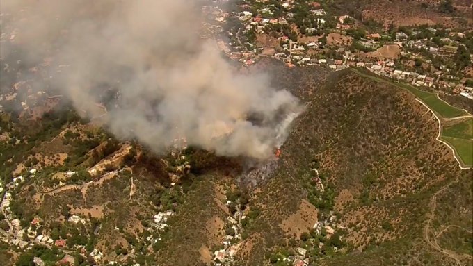
Here are photos of the fire:
Beverly Crest Fire is in steep terrain and heavy brush. Homes at top and bottom of canyon @FOXLA
Oh geez, looks like it’s gonna be an interesting evening. #PortolaFire

#PortolaFire in Beverly Crest now estimated at 32 acres. t.co/Nd1pWnayYa
Great, quick overview video showing what fires are like in urban #LosAngeles & coastal canyons of SoCal: tons of people, onlookers on top of each other, etc t.co/g82k7CTCGv Also, we are seeing more uses of #VR/#AR in such reporting: t.co/KdzYvJwFzs #portolafire

The cause of the fire has not yet been determined.
For the most current information on the #PortolaFire in the Beverly Crest area follow @LAFD.
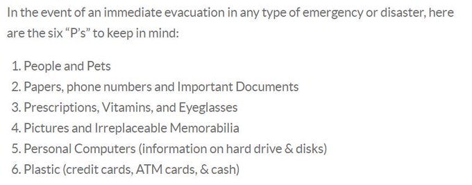
Residents in the immediate area of the fire should be READY to evacuate if asked to do so, with important items loaded in cars. BRING YOUR PETS WITH YOU if you decide to evacuate.
To stay updated on evacuations for this fire, follow @ReadyLA or @LAFD.