The County Fire erupted in California on Saturday and it’s already reached 70,000 acres in size. On Saturday, it was originally called the Guinda Fire in Yolo County and quickly grew to 1,000 acres in just a few hours. By Monday, it was more than 44,000 acres in size. Now it’s at 70,000 acres. Read on to see a map of the fire, learn the latest updates, and read about the current evacuations that have been issued.
County Fire Map & Location
Thanks to red flag fire warnings, including high temperatures, low humidity, and gusty winds, the fire has already grown from 1,000 acres on Saturday evening to 44,500 acres on Monday morning, up to 70,000 acres on Tuesday. It is 5 percent contained. The fire is located at County Road 63 and Highway 16 in Rumsey Canyon. The specific longitude/latitude coordinates, according to CAL FIRE, are -122.18183/38.80583. It’s unclear at this time what started the fire.
You can use this general map of California fires below, provided by Google and CAL FIRE, to see the Guinda / County Fire. Find the County fire and zoom into the location for more details.
Here’s a map of current County Fire boundaries. Just zoom in to the County Fire for more details:
And here is another detailed map of the fire in Yolo County, courtesy of GMAP4 and MappingSupport.com. You can zoom in to see County Fire specifically or zoom out to see the whole state. Note that due to new requirements by Google, the map will no longer be active on July 15.
Here’s a timelapse of the fire from NASA:
And here’s an Ops map:
And another map:
Here is a look at the incident map showing where the #countyfire has burned. The blaze has kept to the east side of #LakeBerryessa.
70,000 acres (~109 square miles)
5% contained
980 structures threatened
2,162 fire personnel

County Fire Evacuations
The following mandatory evacuations have been issued, according to CAL FIRE on July 3:
- North of Highway 128 in Yolo County, not including the City of Winters.
- South of County Road 23
- East of Berryessa Knoxville Road
- Residences served by Highway 128, between Monticello Dam and Pleasant Valley Road
- West of County Road 89, South of the community of Esparto, however agricultural equipment will be permitted
In addition, evacuation advisories have been issued for the following:
- North of Quail Canyon Road
- South of Highway 128
- East of the Blue Ridge mountains
- West of Pleasant Valley Road
- East of Capell Valley Road
- North of State Highway 128 from Capell Valley Road, East to the Napa County line
- All of Steele Canyon Road
According to CAL FIRE, the following road closures are in effect: “Northbound County Road 87 from Highway 128. Berryessa Knoxville Road, from the Pope Creek Bridge to the Napa/Lake County line. Eastbound Highway 128 at Markley Resort. Westbound Highway 128 at Pleasants Valley Road.”
If you’re not sure about evacuations near you, just call 211 for details. An evacuation center has been set up at Guinda Grange Hall in the community of Guinda (16487 Forest Ave. Guinda, CA 95637). Updates will also be posted by CAL FIRE here.
Elevated smoke is expected this week in the Sacramento region because of the fire. Winds are shifting this afternoon.
Here’s an air quality forecast:
Here’s a map showing smoke in the region.
Smoke and haze from the #CountyFire and #PawneeFire seen on satellite filling the valley and surrounding foothills.
Those sensitive to smoke should take extra precautions today. #cawx
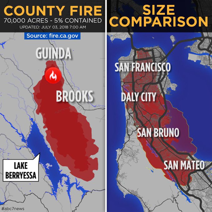
And this size comparison will give you an idea of just how large the fire is.
The #CountyFire has exploded in size and is only 5 percent contained. Here’s a look at the area it would cover if it was burning along the Peninsula. Get a closer look here: t.co/Laf4U59byL
Here are photos of the fire: